
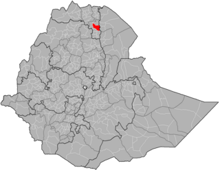
The Tigray Region, officially the Tigray National Regional State, is the northernmost regional state in Ethiopia. The Tigray Region is the homeland of the Tigrayan, Irob, and Kunama people. Its capital and largest city is Mekelle. Tigray is the fifth-largest by area, the fifth-most populous, and the fifth-most densely populated of the 11 regional states.
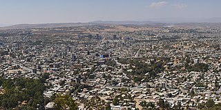
Mekelle, or Mekele, is a special zone and capital of the Tigray Region of Ethiopia. Mekelle was formerly the capital of Enderta awraja in Tigray. It is located around 780 kilometres (480 mi) north of the Ethiopian capital Addis Ababa, with an elevation of 2,254 metres (7,395 ft) above sea level. Administratively, Mekelle is considered a Special Zone, which is divided into seven sub-cities. It is the economic, cultural, and political hub of northern Ethiopia.

Tigray Province, also known as Tigre, was a historical province of northern Ethiopia that overlayed the present day Afar and Tigray regions. Akele Guzai borders with the Tigray province. It encompassed most of the territories of Tigrinya-speakers in Ethiopia. Tigray was separated from the northern Tigrinya speaking territories by the Mareb River, now serving as the state border to Eritrea, bordering Amhara region in the south.

Abiy Addi is a town in central Tigray, Ethiopia. Abiy Addi is at the southeastern edge of the Kola Tembien woreda, of which it is the capital.

Atsbi Wemberta is one of the Districts of Ethiopia, or woredas, in the Tigray Region of Ethiopia. Located in the Misraqawi Zone at the eastern edge of the Ethiopian highlands, Atsbi Wenberta is bordered on the south by the Debub Misraqawi (Southeastern) Zone, on the west by Kilte Awulaelo, on the north by Saesi Tsaedaemba, and on the east by the Afar Region. The administrative center of this woreda is Atsbi ; other towns in Atsbi Wenberta include Haiqi Mesahil, Atsbi Dar'a, Kelisha Emni and Habes. The woreda is administratively divided into 18 tabiyas (municipalities).

Enderta is one of the Districts of Ethiopia or woredas in the Tigray Region of Ethiopia. It was named for the former Enderta province, which was later merged into Tigray Province. Located in the Debub Misraqawi (Southeastern) Zone at the eastern edge of the Ethiopian highlands Enderta is bordered on the south by Hintalo Wajirat, on the west by Samre, on the northwest by the Mehakelegnaw (Central) Zone, on the north by the Misraqawi (Eastern) Zone, and on the east by the Afar Region; the city and special zone of Mek'ele is an enclave within Enderta. Towns in Enderta include Aynalem and Qwiha; the historic village of Chalacot is also located in this woreda.
Hintalo Wajirat is one of the Districts of Ethiopia or woredas in the Tigray Region of Ethiopia. It is named after its largest town, Hintalo, and the Wajirat Mountains in the southern part of the woreda. Located in the Debub Misraqawi (Southeastern) Zone at the eastern edge of the Ethiopian highlands Hintalo Wajirat is bordered on the south by the Debubawi (Southern) Zone, on the west by Samre, on the north by Enderta, and on the east by the Afar Region. Other towns in Hintalo Wajirat include Adi Gudem, and Bahri Tseba.

Chalacot or Chelekot is a village in the Tigray Region of Ethiopia. Located in the Enderta woreda (district) of the Debub Misraqawi (Southeastern) Zone, 10 kilometers north of Antalo and 17 kilometers south of Mek'ele, the village has an approximate elevation of 2100 meters above sea level. The Central Statistical Agency has not published an estimate for this village's 2005 population.

Alula Aba Nega Airport, also known as Mekelle Airport, is an airport serving Mekelle, the capital city of the Tigray Region in northern Ethiopia. The airport is located 10 km southeast of the city.
Hawzen is a town in northern Ethiopia. Located in the Misraqawi (Eastern) Zone of the Tigray Region, this town has a latitude and longitude of 13°58′N39°26′E with an elevation of 2105 meters above sea level. Its market day is Wednesday. It is the largest settlement in Hawzen woreda.

Mekelle University is a higher education and training public institution located in Mekelle, Tigray Region, Ethiopia, 783 kilometers north of Ethiopia's capital, Addis Ababa. Mekelle University is one of the largest public universities in Ethiopia. It has seven colleges, eight institutes, and more than 90 undergraduate and 70 postgraduate programs. The student intake capacity of Mekelle University has reached 31,000 or 10% of Mekelle's population.
Wukro (also transliterated Wuqro; is a town and separate woreda in Tigray, Ethiopia. Wukro is located along Genfel River, in the Misraqawi zone of the Tigray region on the Asmara-Addis Ababa highway. Wukro is surrounded by Kilte Awulaelo woreda. The rock-hewn churches around Wukro are the town's most distinctive landmarks. In earlier sources the area is usually referred to as Dongolo before the foundation of Wukro as a modern town, after the name of the main village nearby, while the term Wukro just referred originally to the church area of Wuqro Cherqos which was situated within the land of Dongolo village. Due to the establishment of modern infrastructure, including a far-distance road, the area around Wuqro Cherqos evolved into a town by itself, thus separated from Dongolo and became an economic and administrative centre by itself. The town's name derives from the Tigrigna word for a structure carved from the living rock, Wukro.
Atsbi is a town in Tigray, Ethiopia. Located in the Misraqawi (Eastern) Zone of the Tigray Region, about 50 kilometers northeast of Qwiha, this town has a latitude and longitude of 13°52′N39°44′E with an elevation of 2630 meters above sea level. It is the administrative center of Atsbi Wenberta woreda.
Saint George's Cathedral is an Ethiopian Orthodox church in Addis Ababa, Ethiopia. The cathedral is noted for its distinctive octagonal form. It is located at the northern end of Churchill Road in the city.
Enderta or Inderta is a former historical province of Ethiopia; it is located in the eastern edge of the Tigray highlands. Enderta is bordered on the west by Tembien, on the south and southwest by Lasta and Wag, on the east by denkel, and on the north by Agame and Adwa. Mekelle was formerly the capital of the province. Enderta's local administration of Denkel/Afar up to the edges of Aseb under its jurisdiction seems to have been highly, interlinked with the operation of the salt trade and its taxation system; the entire tasks of salt caravan organization being the responsibility of the bäalgada, title assumed by the governor of Endärta, since at least the Medieval period (c.1270-1527)

Agula is a town located in northern Ethiopia. Located in the Debubawi (Southern) Zone of the Tigray Region, it lies about 32 km northeast of Mekelle, just east of the Mekelle to Addis Ababa highway, and 25 km north of Qwiha. It has a latitude and longitude of 13°41′30″N39°35′30″E with an elevation of 1,930 metres above sea level. It is one of three towns in Kilte Awulaelo woreda. Nearby is a stream and a pass which share the same name. Agula was an important station on the salt caravan route from Dallol west to Atsbi.
Dergajen was a woreda in Enderta Province, in Tigray Region, Ethiopia. Its administrative center was Kwiha; now is a tabia (municipality) located 19 kilometers east of Kwiha, Ethiopia. The administrative center of the tabia is located in the village of Aragure. A weekly market is organized in Aragure. According to the 2007 census, 9524 people were living in the tabia, which results in a population density of 68 inhabitants per square kilometer.
Tembien is a historic region in Tigray Region and former provinces of Ethiopia. It is a mountainous area of that country. During the reforms in 1994–95, the old provinces were replaced with regions, zones and woredas. The area of the former province is now split over the woredas of Dogua Tembien and Kola Tembien.

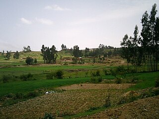
Haddinnet, also transliterated as Hadnet, is a tabia or municipality in the Dogu'a Tembien district of the Tigray Region of Ethiopia. The tabia centre is in Addi Idaga village, located approximately 6.5 km to the northeast of the woreda town Hagere Selam.
The Transitional Government of Tigray was a caretaker administration that was formally declared by the House of Federation of Ethiopia on 7 November 2020, in the context of a conflict between the Tigray People's Liberation Front (TPLF), in power in the Tigray Regional State and the federal government of Ethiopia. In late November 2020, the administration, headed by Mulu Nega, planned public consultation and participation in choosing new leaders at the regional and zonal level and preservation of woreda and kebele administrations. The Transitional Government left Tigray in late June 2021 during Operation Alula.

