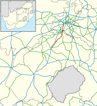
The R387 is a Regional Route in South Africa that connects the N12 near Strydenburg with the R369 near Orania. [1]
| Regional route R387 | ||||
|---|---|---|---|---|
| Location | ||||
| Country | South Africa | |||
| Highway system | ||||
| ||||
The R387 is a Regional Route in South Africa that connects the N12 near Strydenburg with the R369 near Orania. [1]
| Regional route R387 | ||||
|---|---|---|---|---|
| Location | ||||
| Country | South Africa | |||
| Highway system | ||||
| ||||

Cape Town is the legislative capital of South Africa. It is the country's oldest city and the seat of the Parliament of South Africa. It is the country's second-largest city, after Johannesburg, and the largest in the Western Cape. The city is part of the City of Cape Town metropolitan municipality.

Mbombela, formerly Nelspruit, is a city in northeastern South Africa. It is the capital of the Mpumalanga province. Located on the Crocodile River, the city lies about 110 km (68 mi) by road west of the Mozambique border, 330 km (210 mi) east of Johannesburg and 82 km (51 mi) north of the Eswatini border. Mbombela was one of the host cities of the 2010 FIFA World Cup.

The N3 is a national route in South Africa that connects Johannesburg and Durban, respectively South Africa's largest and third-largest cities. Johannesburg is the financial and commercial heartland of South Africa, while Durban is South Africa's key port and one of the busiest ports in the Southern Hemisphere and is also a holiday destination. Durban is the port through which Johannesburg imports and exports most of its goods. As a result, the N3 is a very busy highway and has a high volume of traffic.

The N1 is a national route in South Africa that runs from Cape Town through Bloemfontein, Johannesburg, Pretoria and Polokwane to Beit Bridge on the border with Zimbabwe. It forms the first section of the famed Cape to Cairo Road.

The R21 is a major north–south provincial route in eastern Gauteng Province, South Africa. Built in the early 1970s, it remains one of two freeways linking Pretoria with Johannesburg, via the R24. As the eastern of the two freeways, it links the Pretoria city centre with OR Tambo International Airport and Boksburg. Between the Solomon Mahlangu Drive on-ramp in Monument Park, Pretoria, and the N12 interchange in Boksburg, the R21 is an 8 lane highway and motorway (freeway), with 4 lanes in each direction. It has off-ramps leading to Irene, Olifantsfontein, Benoni, and Kempton Park. The route intersects the N1 highway near Centurion, the R24 near the airport, the N12 and N17 in Boksburg, and the N3 near Vosloorus on the East Rand, where it ends. The section from the N12 to the N3 is not a freeway. The R21 is also designated as the P157.

The R25 is a provincial route in South Africa that connects Johannesburg with Groblersdal via Kempton Park, Bapsfontein and Bronkhorstspruit.
Regional routes are the third category of road in the South African route numbering scheme. They are designated with the letter "R" followed by a three-digit number. They serve as feeders connecting smaller towns to the national and provincial routes. Designation as a regional road does not necessarily imply any particular size of road; they range from gravel roads to multi-lane freeways.

The R82 is a provincial route in South Africa that connects Johannesburg with Kroonstad via Vereeniging and Sasolburg. It starts just south of the M1 Johannesburg Municipal Highway's interchange with the N12 Southern Bypass, going south, meeting the R59, R54, R42 & R28 routes at Vereeniging before crossing the Vaal River into the Free State & proceeding to Kroonstad. It is an alternative, but longer route to the N1 national route between Johannesburg & Kroonstad.

The R102 is a Regional Route in South Africa. It is the route designation for all old sections of the N2, thus it is a discontinuous road that resumes in areas where a new N2 has been constructed.
The R319 is a Regional Route in South Africa that connects L'Agulhas and Struisbaai in the south with the N2 near Swellendam via Bredasdorp.
The R322 is a Regional Route in South Africa. Its northern origin is a t-junction with the R324 between Suurbraak and Barrydale. The northern and western routes are signed the R324, with R322 heading just south of east. It reaches Heidelberg where it meets the N2. It becomes co-signed with this route, heading just south of west. After a short distance, it diverges from the N2 and heads south-south-west. The route ends at Port Beaufort where it rejoins the R324.
The R327 is a Regional Route in South Africa. Its a regional route in the Western Cape and connects Mossel Bay to Ladismith and part of the northern route is a gravel road.
The R340 is a Regional Route in South Africa that connects the N2 at Keurboomsrivier near Plettenberg Bay in the south-east with the R339.
The R355 is a Regional Route in South Africa that connects the R46 near Ceres with Kleinsee via Calvinia and Springbok.
The R356 is a Regional Route in South Africa that connects the R46 near Ceres with Loxton by way of Sutherland and Fraserburg.
The R364 is a Regional Route in South Africa that connects Lamberts Bay to the R27 between Calvinia and Nieuwoudtville via Clanwilliam.

The N2 is a national route in South Africa that runs from Cape Town through George, Gqeberha, East London, Mthatha, Port Shepstone and Durban to Ermelo. It is the main highway along the Indian Ocean coast of the country. Its current length of 2,255 kilometres (1,401 mi) makes it the longest numbered route in South Africa.

Sir Lowry's Pass is a mountain pass on the N2 national road in the Western Cape province of South Africa. It crosses the Hottentots Holland Mountains between Somerset West and the Elgin valley, on the main route between Cape Town and the Garden Route. A railway line also crosses the mountain range near this point.

The R62 is a provincial route in South Africa that connects Ashton with Humansdorp. The R62 runs through the Little Karoo and the Langkloof, passing through Montagu, Ladismith, Calitzdorp, Oudtshoorn, and Joubertina.

Provincial routes are the second category of road in the South African route-numbering scheme. They are designated with the letter "R" followed by a number from 21 to 82, formerly with the letter "P" followed by a number from 66. They serve as feeders to the national routes and as trunk roads in areas where there is no national route.