The N1 is a national route in South Africa that runs from Cape Town through Bloemfontein, Johannesburg, Pretoria and Polokwane to Beit Bridge on the border with Zimbabwe. It forms the first section of the famed Cape to Cairo Road.

Welkom is the second-largest city in the Free State province of South Africa, located about 140 kilometres (90 mi) northeast of Bloemfontein, the provincial capital. Welkom is also known as Circle City, City Within A Garden, Mvela and Matjhabeng. The city's Sesotho name, Matjhabeng means 'where nations meet', derived from the migrant labour system, where people of various countries such as Lesotho, Malawi and Mozambique etc. met to work in the mines of the gold fields.

The R30 is a provincial route in South Africa that connects Bloemfontein with Rustenburg via Brandfort, Welkom, Bothaville, Klerksdorp and Ventersdorp. The southern part of the route is tolled, as the R30 forms the first section of the ZR Mahabane Toll Route, with the Brandfort Toll Plaza found 10 kilometres north of its southern terminus junction with the N1 national route. The tolled portion ends at the junction with the R730.

The R31 is a provincial route in the Northern Cape of South Africa that connects Kimberley with the Namibian border at Rietfontein via Kuruman and Hotazel. It is co-signed with the R360 between Askham and Andriesvale.

The R33 is a provincial route in South Africa that connects Pietermaritzburg with Lephalale via Greytown, Paulpietersburg, Carolina, Belfast and Vaalwater. It is a very long road, passing through 3 provinces.

The R34 is a long provincial route in South Africa that connects Vryburg with Richards Bay via Kroonstad and Newcastle. It passes through three provinces, North West, the Free State and KwaZulu-Natal.

The R36 is a provincial route in South Africa that connects the N1 at Bandelierkop with Ermelo, via Tzaneen and Lydenburg. It is co-signed with the N4 for 8 kilometres between Machadodorp and Patattanek, with a tollgate on this section. It used to extend further south past Ermelo to Amersfoort, but that section is now designated as part of the N11.

The R48 is a provincial route in South Africa that connects De Aar with Petrusburg on the N8 via Petrusville and Koffiefontein.

The R59 is a provincial route in South Africa that connects Hertzogville with Alberton via Bothaville, Parys and Vereeniging. The R59 is a freeway from the R57 Junction in Sasolburg until the N12 Reading Interchange in Alberton, signposted as the Sybrand van Niekerk Freeway.

The R63 is a tarred provincial route in South Africa that connects Calvinia with Komga via Carnarvon, Victoria West, Graaff-Reinet, Somerset East and King William's Town. It is cosigned with the N10 between Eastpoort and Cookhouse for 24 kilometres.

The R70 is a provincial route in the Free State Province, South Africa that connects Odendaalsrus with Ficksburg via Ventersburg and Senekal.

The R73 is a provincial route in Free State, South Africa that connects Welkom with Winburg via Virginia.

The N12 is a national route in South Africa which runs from George through Beaufort West, Kimberley, Klerksdorp and Johannesburg to eMalahleni.

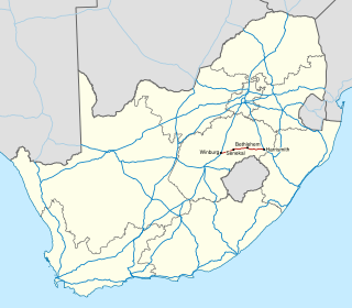
The N5 is a national route in South Africa that connects the N1 at Winburg with the N3 at Harrismith, via Senekal, Paul Roux and Bethlehem.

The N8 is a national route in South Africa that connects Groblershoop with Maseru in Lesotho via Kimberley and Bloemfontein. It is maintained by the South African National Roads Agency.

The N11 is a national route in South Africa which runs from the Botswana border at Groblersbrug, through Mokopane, Middelburg, Ermelo and Newcastle to end at the N3 just after Ladysmith.

The N14 is a national route in South Africa which runs from Springbok in the Northern Cape to Pretoria in Gauteng. It passes through Upington, Kuruman, Vryburg, Krugersdorp and Centurion. The section between Pretoria and Krugersdorp is maintained by the Gauteng Provincial government and is also designated the P158.
The R700 is a regional route in Free State, South Africa that connects Hoopstad with Bloemfontein via Bultfontein and Soutpan.
The R708 is a Regional Route in South Africa that connects Jan Kempdorp in the Northern Cape with Clocolan in the Free State via Christiana, Hertzogville, Bultfontein, Theunissen, Winburg and Marquard.
The R730 is a Regional Route in Free State, South Africa. The entire 40-kilometre route is part of the ZR Mahabane Toll Route maintained by the South African National Roads Agency, which goes from Bloemfontein to Kroonstad. Although there are no tollgates on this stretch at the moment, it is labelled as a toll road to the near public and to motorists using the road.


