 | ||||
|---|---|---|---|---|
| Route information | ||||
| Length | 35 km (22 mi) | |||
| Major junctions | ||||
| North end | ||||
| South end | ||||
| Location | ||||
| Country | South Africa | |||
| Highway system | ||||
| ||||
The R711 is a Regional Route in Free State, South Africa that connects Clarens with Fouriesburg. [1]
| | ||||
|---|---|---|---|---|
| Route information | ||||
| Length | 35 km (22 mi) | |||
| Major junctions | ||||
| North end | ||||
| South end | ||||
| Location | ||||
| Country | South Africa | |||
| Highway system | ||||
| ||||
The R711 is a Regional Route in Free State, South Africa that connects Clarens with Fouriesburg. [1]
The R711's northern terminus is in Clarens, at a junction with the R712, which goes north to Bethlehem and east to the Golden Gate Highlands National Park. The R711 heads south from Clarens before turning west to end at an intersection with the R26 at Fouriesburg. [1]

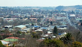
Bethlehem is a city in the eastern Free State province of South Africa that is situated on the Liebenbergs River along a fertile valley just north of the Rooiberg Mountains on the N5 road. It is the fastest growing city in the Free State province, with its target of being the third largest city after Bloemfontein and Welkom.

Clarens is a small town situated in the foothills of the Maluti Mountains in the Free State province of South Africa and nicknamed the "Jewel of the Eastern Free State". It was established in 1912 and named after the town of Clarens in Switzerland where exiled Paul Kruger spent his last days. It is situated 336 km from Johannesburg, 284 km from Bloemfontein, and 389 km from Durban.

Fouriesburg is a small town situated at the junction of the R711 and R26 routes in the eastern Free State, South Africa. It is near the Maluti Mountains and only 10 km from Caledon's Poort border post, which gives access to Lesotho.

The Province of the Orange Free State, commonly referred to as the Orange Free State, Free State or by its abbreviation OFS, was one of the four provinces of South Africa from 1910 to 1994. After 27 April 1994 it was dissolved following the first non-racial election in South Africa. It is now called the Free State Province.

Stephen McClaren is an English football coach and former player who is currently the manager of the Jamaica national team.

Clarens-Montreux or Clarens is a neighbourhood in the municipality of Montreux, in the canton of Vaud, in Switzerland. This neighbourhood is the biggest and most populated of the city of Montreux.

Golden Gate Highlands National Park is located in Free State, South Africa, near the Lesotho border. It covers an area of 340 km2 (130 sq mi). The park's most notable features are its golden, ochre, and orange-hued, deeply eroded sandstone cliffs and outcrops, especially the Brandwag rock. Another feature of the area is the numerous caves and shelters displaying San rock paintings. Wildlife featured at the park includes mongooses, eland, zebras, and over 100 bird species. It is the Free State's only national park and is more famous for the beauty of its landscape than for its wildlife. Numerous palaeontology finds have been made in the park, including dinosaur eggs and skeletons.

The Clarens Formation is a geological formation found in several localities in Lesotho and in the Free State, KwaZulu-Natal, and Eastern Cape provinces in South Africa. It is the uppermost of the three formations found in the Stormberg Group of the greater Karoo Supergroup rocks and represents the final phase of preserved sedimentation of the Karoo Basin.
The Bushveld Sandstone is a geological formation dating to roughly between 201 and 189 million years ago and covering the Carnian to Norian stages. The Bushveld Sandstone is found in Transvaal, South Africa, and is a member of the Stormberg Group. As its name suggests, it consists mainly of sandstone. Fossils of the prosauropod dinosaur Massospondylus have been recovered from the Bushveld Sandstone.
Notochampsa is an extinct genus of protosuchian crocodyliform. Fossils have been found from the lower Clarens Formation of the Karoo Supergroup in South Africa, dating back to the Pliensbachian stage of the Early Jurassic. Notochampsa comes from a period of relative fossil scarcity, and is the youngest known occurrence of a crocodylomorph from the Karoo Basin of South Africa.

The Volksblad was an Afrikaans-language daily newspaper published in Bloemfontein, South Africa, and distributed in the Free State and Northern Cape provinces, where it was the largest Afrikaans daily. It was South Africa's oldest Afrikaans until it closed in 2020. The paper was owned by Media24.
Dihlabeng Municipality is a local municipality within the Thabo Mofutsanyane District Municipality, in the Free State province of South Africa. It was established after the first general local government elections on 5 December 2000, which heralded the final phase of local government reform as envisaged in 1994 at the onset of the process of democratisation and the end of apartheid. The seat is Bethlehem.

The R712 is a Regional Route in South Africa that connects Phuthaditjhaba with Bethlehem via the Golden Gate Highlands National Park and Clarens.

Orange Free State Command was a command of the South African Army, active from c. 1933 to c. 1999. Its headquarters was at Bloemfontein, seemingly for a period at the Tempe airfield, later to become the Tempe Military Base.
Fouriesburg Commando was a light infantry regiment of the South African Army. It formed part of the South African Army Infantry Formation as well as the South African Territorial Reserve.
For thousands of years, a pilgrimage has been made by the Basotho people to a network of sacred caves to communicate with the spiritual world. The caves also contain dinosaur footprints and ancient rock paintings. The caves are located between the eastern parts of the Free State and Lesotho. These sacred caves are often described as 'the key to religion' in Southern Africa.
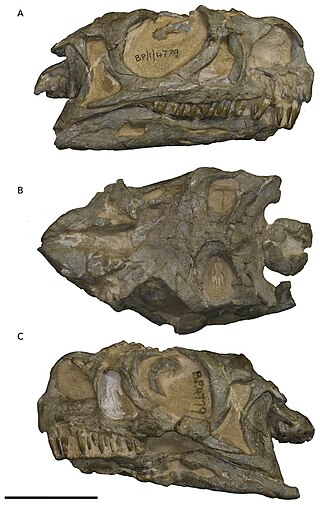
Ngwevu is a genus of massospondylid sauropodomorph dinosaur from the Lower Jurassic of South Africa. The genus contains one species, Ngwevu intloko.
Paul Hendrik Roux was a Second Boer War general and a Protestant pastor in the Dutch Reformed Church in South Africa (NGK).

The Brandwater Basin is the drainage basin of the Brandwater River, a tributary of the Grootspruit River in the south-east of Orange Free State, South Africa, north of Lesotho. The basin is situated south of Bethlehem and south-east of Senekal, between the Witteberg to the west and north, the Rooiberge to the east, and the Drakensberg over the Caledon River to the south. It is also northwest of the Slaapkrans Basin and the Maloti Mountains on the northern border of Lesotho. Towns in the Brandwater Basin are Fouriesburg, founded in 1892, and Clarens, established in 1912.
| | This South African road or road transport-related article is a stub. You can help Wikipedia by expanding it. |