Rabbit River (Mississippi River tributary)

Last updated
Rabbit River
Country United States
Physical characteristics
Main source Minnesota

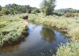
The Rabbit River is an 8.6-mile-long (13.8 km) [1] tributary of the Mississippi River in northern Minnesota, United States. It rises at the outlet of Rabbit Lake, north of Crosby, and flows southwest through a chain of lakes past Ironton, joining the Mississippi River at the outlet of Little Rabbit Lake northwest of Riverton.

Mississippi River largest river system in North America

The Mississippi River is the second-longest river and chief river of the second-largest drainage system on the North American continent, second only to the Hudson Bay drainage system. Its source is Lake Itasca in northern Minnesota and it flows generally south for 2,320 miles (3,730 km) to the Mississippi River Delta in the Gulf of Mexico. With its many tributaries, the Mississippi's watershed drains all or parts of 32 U.S. states and two Canadian provinces between the Rocky and Appalachian mountains. The main stem is entirely within the United States; the total drainage basin is 1,151,000 sq mi (2,980,000 km2), of which only about one percent is in Canada. The Mississippi ranks as the fourth-longest and fifteenth-largest river by discharge in the world. The river either borders or passes through the states of Minnesota, Wisconsin, Iowa, Illinois, Missouri, Kentucky, Tennessee, Arkansas, Mississippi, and Louisiana.

Minnesota State of the United States of America

Minnesota is a state in the Upper Midwest, Great Lakes, and northern regions of the United States. Minnesota was admitted as the 32nd U.S. state on May 11, 1858, created from the eastern half of the Minnesota Territory. The state has a large number of lakes, and is known by the slogan the "Land of 10,000 Lakes". Its official motto is L'Étoile du Nord.

United States Federal republic in North America

The United States of America (USA), commonly known as the United States or America, is a country comprising 50 states, a federal district, five major self-governing territories, and various possessions. At 3.8 million square miles, the United States is the world's third or fourth largest country by total area and is slightly smaller than the entire continent of Europe's 3.9 million square miles. With a population of over 327 million people, the U.S. is the third most populous country. The capital is Washington, D.C., and the largest city by population is New York City. Forty-eight states and the capital's federal district are contiguous in North America between Canada and Mexico. The State of Alaska is in the northwest corner of North America, bordered by Canada to the east and across the Bering Strait from Russia to the west. The State of Hawaii is an archipelago in the mid-Pacific Ocean. The U.S. territories are scattered about the Pacific Ocean and the Caribbean Sea, stretching across nine official time zones. The extremely diverse geography, climate, and wildlife of the United States make it one of the world's 17 megadiverse countries.

See also

Related Research Articles

Wing River (Leaf River tributary) tributary of the Leaf River in Minnesota, United States of America

The Wing River is a 48.2-mile-long (77.6 km) tributary of the Leaf River in west-central Minnesota in the United States. Via the Leaf and Crow Wing rivers, it is part of the Mississippi River watershed. Wing River Township is named for the river.

The Nokasippi River is a 46.5-mile-long (74.8 km) tributary of the Mississippi River in central Minnesota in the United States. In the Ojibwe language, the river is called Nooke-ziibi. The term "tender" generally refers to the Bear Totem, but in this case refers to Chief Nokay, who was named after the Bear Totem and lived along the shores of Nokay Lake.

The Little Nokasippi River is a 13.8-mile-long (22.2 km) tributary of the Nokasippi River in Crow Wing County, Minnesota. It joins the Nokasippi just 1.0 mile (1.6 km) upstream from that river's mouth at the Mississippi River.

The Platte River is a tributary of the Mississippi River in central Minnesota in the United States. It is 55.1 miles (88.6 km) long. Platte is a name derived from the French meaning "flat".

Leaf River (Minnesota) tributary of the Crow Wing River in Minnesota, United States of America

The Leaf River is a 43.6-mile-long (70.2 km) tributary of the Crow Wing River in west-central Minnesota in the United States. Via the Crow Wing, it is part of the Mississippi River watershed.

Cobb River (Minnesota) river in the United States of America

The Cobb River and its tributary the Little Cobb River are small rivers in southern Minnesota in the United States. The Cobb River is a 78.6-mile-long (126.5 km) tributary of the Le Sueur River. Via the Le Sueur, Blue Earth and Minnesota rivers, it is part of the watershed of the Mississippi River.

The Blackduck River is a 33.2-mile-long (53.4 km) tributary of Red Lake in northwestern Minnesota in the United States.

The Cat River is a 16.3-mile-long (26.2 km) tributary of the Crow Wing River in the U.S. state of Minnesota. It is part of the Mississippi River drainage basin.

Clearwater River (Mississippi River tributary) river in Stearns County, United States of America

The Clearwater River is a 43.4-mile-long (69.8 km) tributary of the Mississippi River in central Minnesota, United States.

The Gull River is a 14.2-mile-long (22.9 km) tributary of the Crow Wing River in the U.S. state of Minnesota. Rising at the outlet of Gull Lake, it flows south through Cass and Crow Wing counties to the Crow Wing River 2 miles (3 km) southeast of Sylvan. It is part of the Mississippi River drainage basin.

The Little Pine River is a 29.7-mile-long (47.8 km) tributary of the Pine River of Minnesota in the United States. Via the Pine River it is part of the Mississippi River watershed. The Little Pine River begins in the northeast corner of Crow Wing County at the outlet of Little Pine Lake and flows southwest to its junction with the Pine River in Crow Wing State Forest.

The Little Willow River is a 26.2-mile-long (42.2 km) tributary of the Mississippi River in northern Minnesota, United States. It rises in western Aitkin County at the outlet of Esquagamah Lake and flows generally south to its junction with the Mississippi River 3 miles (5 km) northwest of Aitkin.

The Moose Horn River is a 36.4-mile-long (58.6 km) tributary of the Kettle River in eastern Minnesota, United States. It is part of the St. Croix River watershed, flowing eventually to the Mississippi River. It rises at the outlet of Wild River Lake, 7 miles (11 km) southwest of the city of Cloquet, and flows southwest through Carlton County, roughly parallel to Interstate 35. The river passes the communities of Mahtowa, Barnum, and Moose Lake, ending at the Kettle River southwest of the city of Sturgeon Lake.

The North Two River is a 22.4-mile-long (36.0 km) tributary of the Two River in central Minnesota. It is part of the Mississippi River watershed.

The Pine River is a 56.9-mile-long (91.6 km) tributary of the Mississippi River in northern Minnesota, United States.

The Portage River is an 8.8-mile-long (14.2 km) tributary of the Moose Horn River in eastern Minnesota, United States. It flows west to the Moose Horn River, joining it at Moosehead Lake next to the city of Moose Lake. By the Moose Horn River, its waters flow to the Kettle River, St. Croix River, and ultimately the Mississippi River. Just to the east of the Portage River, Nemadji Creek flows east to the Nemadji River, a tributary of Lake Superior and part of the Saint Lawrence River basin.

The Rabbit River is a 31.5-mile-long (50.7 km) tributary of the Bois de Sioux River of Minnesota in the United States. Via the Bois de Sioux River, Red River of the North, Lake Winnipeg, and the Nelson River, it is part of the Hudson Bay watershed.

The Rice River is a 57.1-mile-long (91.9 km) tributary of the Mississippi River in northern Minnesota, United States. It rises in southeastern Aitkin County at the outlet of Porcupine Lake and flows generally north into Rice Lake National Wildlife Refuge, where it turns west and flows to the Mississippi 5 miles (8 km) northeast of Aitkin.

Sleepy Eye Creek is a 51.8-mile-long (83.4 km) tributary of the Cottonwood River of Minnesota, the United States. Via the Cottonwood River, its water flows to the Minnesota River and eventually the Mississippi River.

The South Two River is a 22.8-mile-long (36.7 km) tributary of the Two River of Minnesota, United States. It is part of the Mississippi River watershed.

References

  1. U.S. Geological Survey. National Hydrography Dataset high-resolution flowline data. The National Map, accessed December 26, 2012