
Khagaria district is an administrative district in Mithila region in the state of Bihar in India. The district headquarters are located at Khagaria. Earlier it was a part of Munger District as a sub-division that was created in 1943–44. It was upgraded to the status of a district on 10 May 1981. Khagaria district is a part of Munger Division.
Kakhandaki village, situated in Bijapur taluk, is located approximately 33 kilometers away from the district headquarters and 11 kilometers from the proposed Babaleshwar Taluk. The village is renowned for its vibrant festivities, notably the "KARAHUNNIME" festival and Sri Guru Mahipathi Dasar Aradhane. The KARAHUNNIME (KARI) festival is celebrated one week after the full moon in the month of June and draws a large crowd. A highlight of this festival is the traditional "TAMING OF OX" ritual, where bullocks or oxen are adorned with ropes and managed by skilled team members, all dressed in a uniform attire. The following day, Okuli is observed as part of the Sri Hanuman Jatra Mahotsava festivities. Witnessing KARI and Okali is an exhilarating experience, attracting an audience of around 8-10 thousand spectators.
Asarganj is urban area in Munger district in the state of Bihar, India.

Mohanpur is a community development block that forms an administrative division in the Kharagpur subdivision of Paschim Medinipur district in the Indian state of West Bengal.
Chakia is a small town and the sub-divisional headquarters of Chakia Tehsil in the District of Chandauli of Varanasi Division in the northern Indian state of Uttar Pradesh.

Nokha is a nagar panchayat town and corresponding community development block in Rohtas district in the Indian state of Bihar. As of 2011, the population of the town of Nokha was 27,302 in 4,381 households. The rural population of Nokha block was 146,025, thus bringing the total block population 173,327. The economic situation of this region is mainly dependent on parboiled rice processed by number of rice mills in this area.
Ahirauli Baghel is an Indian village located in Uttar Pradesh, India. Ahirauli Baghel comes under Bankata Block of Deoria district. It belongs to Gorakhpur division. It is located 47 KM towards East from district headquarter Deoria. It distance is 374 KM from State capital Lucknow. Bhojpuri and Hindi is the primary language spoken in this village.

Arangi is a small village of Kamsaar located in Seorai tehsil of Ghazipur district, Uttar Pradesh, India. The village is located in the eastern parts Varanasi division, situated almost at the border of Uttar Pradesh and Bihar, on the left bank of the river Karmnasha. Arangi contains an old monument to Lord Buddha.
Chhoti Ballabh is a village situated in the Gonda block of Iglas tehsil in Aligarh district, Uttar Pradesh, India.
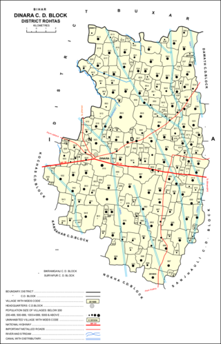
Dinara is a CD Block in Rohtas district, Bihar, India. It is situated on the National Highway 319. The birthplace of the famous poet Dariya Saheb is just 5 km from Dinara.

Akhand Nagar is a community development block in Kadipur tehsil of Sultanpur district, Uttar Pradesh, India. It consists of 106 inhabited villages with a total population of 168,686 people in 25,112 households.

Saifai is a large village and university town in the Etawah district of the Indian state of Uttar Pradesh. It is also a sub-division (Tehsil) and Block of the Etawah district. It is the birthplace of Mulayam Singh Yadav, the founding president of the Samajwadi Party, former Minister of Defence, in India and former Chief Minister of Uttar Pradesh.
Babhangawan is a village in Lakhisarai district, Bihar, India.
Bakulari is a village located in Sohagara Panchayat of Guthani Block of Siwan district in the Indian state of Bihar.

Mokar is a Village located in Sasaram tehsil of Rohtas district in Bihar, India. It is situated 5 km away from Sasaram, which is both district & sub-district headquarter of Mokar village. As per 2009 stats, Mokar village is also a gram panchayat.
Lasanpur is a large village located in Dagarua of Purnia district, Bihar with total 437 families residing. It has population of 2126 of which 1115 are males while 1011 are females as per Population Census 2011.
Bhadon is a village and Gram Panchayat located in Martinganj tehsil of the Azamgarh District in the Indian state of Uttar Pradesh, near the border with Jaunpur District. It is 37.7 kilometres (23.4 mi) north-east of the district headquarters in Azamgarh and 229.9 kilometres (142.9 mi) from the state capital of Lucknow.

Taudhakpur, also known as Mirzapur Urf Taudhakpur, is a village located in Raebareli district, in the state of Uttar Pradesh, India. The village is 31 km from Raebareli and 87 km from Lucknow. As of 2011, the village had the population of 833 with 70.43% literacy rate. With the introduction of a digitized information center and modern-age communication facilities in 2018, Taudhakpur became the first smart village of India.

Suryapura, also spelled Surajpura, is a village and corresponding community development block in Rohtas district of Bihar, India. As of 2011, the village of Suryapura had a population of 6,347, in 900 households, while Suryapura block had a population of 57,529, in 8,728 households. It is the least populous of Rohtas's 19 blocks.
Ismailpur Block is block within the Bhagalpur District of Bihar, India. The pin code for Ismailpur is 853205, and the postal head office is S.T. Goriar.It comes under Naugachhia subdivision.It is a part of Anga region of Bihar.

