Rail transport on the Mariana Islands

Last updated
NKK Saipan sugar mill.JPG
NKK sugar mill, Saipan
NKK Sugar train.JPG
NKK sugar train, Saipan
NKK Sugar train 1.JPG
NKK picnic train

Rail transport on the Mariana Islands was mainly related to the transport of sugar cane and military supplies by narrow gauge railways.

Contents

Saipan

Marines rest along the narrow gauge Japanese railroad on Saipan, July 1944 Troops resting beside the narrow gauge Japanese railroad on Saipan.jpg
Marines rest along the narrow gauge Japanese railroad on Saipan, July 1944

Japanese business man, Haruji Matsue, that introduced sugar cane farms and narrow gauge railways to the Island of Saipan in the 1920s. [1] A narrow-gauge railway with a gauge of 760 mm (2 ft 5+1516 in) nearly circled the island of Saipan and has been used by the Japanese for transporting sugar cane and military supplies. [2] [3] The operation of the railway from Charan-Kanoa to the Aslito air field was taken over by a Seabees attached to the 4th Mar. Regiment. Their commander Lt. Cmdr. William G. Byrne had focussed on re-using the railway since seeing it in intelligence. Fortunately, the Japanese had not sabotaged the nearly 100 miles of track or rolling stock. The Seabees took over nine locomotives with two of them beyond repair. Three were running by 22 July 1944. The other four followed. [4]

Steam locomotive at Sugar King Park, Saipan Steam locomotive at Sugar King Park.JPG
Steam locomotive at Sugar King Park, Saipan

The Seabees had one diesel locomotive and three steam locomotives, plus 100 flat cars they turned over to the Army's Transportation people. The railway was operated by the 1398th Engineer Construction Battalion. At the end of July 1944 the traffic volume was 150 tonne-miles (240 tonne-kilometres) per day. [2] [5] [6] However, some rail lines were taken up and replaced by roadway on the existing right of way. Two of the steam locomotives were modified to sterilize waste bins. [2] One locomotive has been parked in Sugar King Park, at Garapan. [7]

Rota and Tinian

By 1925 Matsue had built an alcohol factory and ice plant (NKK) on Saipan, planted over 3000 hectares of sugar. Subsequently, he established similar facilities on the neighbouring islands of Rota and Tinian. Each of the plantations had its own narrow gauge railway network. The mills were destroyed during World War II and did not reopen. As a relic of the railway a locomotive has been preserved on the island of Rota. [7]

Guam

Japanese narrow gauge railroad locomotive at the Orote Peninsula Airfield, Guam, Mariana Islands, 5 October 1944 Japanese narrow gauge railroad locomotive at the Orote Peninsula Airfield, Guam, Mariana Islands, 5 Oct 1944.jpg
Japanese narrow gauge railroad locomotive at the Orote Peninsula Airfield, Guam, Mariana Islands, 5 October 1944

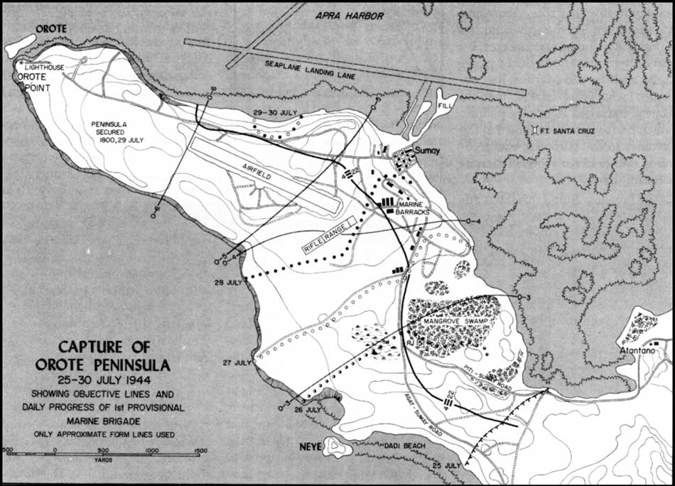
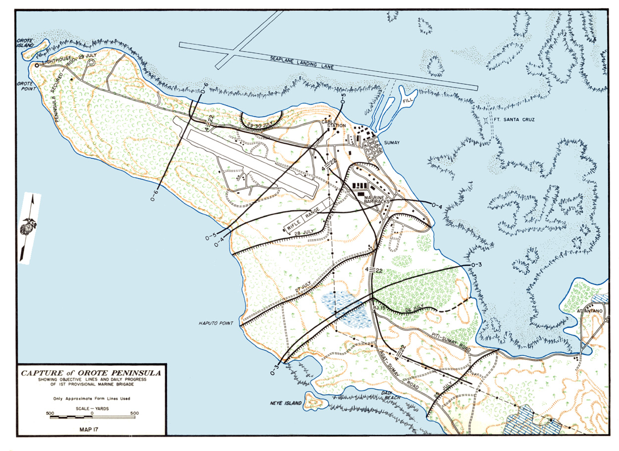
Two Japanese narrow-gauge diesel locomotives were photographed on 5 October 1944, while being placed on wooden beams at the airfield on the Orote Peninsula in Guam. They were used as cover during the Landing of US-American troops and thus severely damaged. It is not known, whether they were previously used for rail transport or had only just been delivered shortly before the landing of the US-American troops. [8] There are no railway tracks shown on the peninsula on maps of that period of time. [9] [10]

Related Research Articles

Modes of transport in Fiji include rail, road, water, and air. The rail network is mainly used for movement of sugar cane. Suva and Lautoka are the largest seaports. There are 122km of navigable inland waterways. There are two international airports, one other paved airport, and over 20 with unpaved runways. With 333 tropical islands that make up this country, one can expect to use various modes of transport to get to their destination.

<span class="mw-page-title-main">Battle of Tinian</span> 1944 World War II battle between the United States and Japan

The Battle of Tinian was a battle of the Pacific campaign of World War II, fought on the island of Tinian in the Mariana Islands from 24 July until 1 August 1944. The 8,000-man Japanese garrison was eliminated, and the island joined Saipan and Guam as a base for the Twentieth Air Force.

<span class="mw-page-title-main">Battle of Guam (1944)</span> WWII battle in the Pacific theater between US and Japan

The Battle of Guam was the American recapture of the Japanese-held island of Guam, a U.S. territory in the Mariana Islands captured by the Japanese from the United States in the First Battle of Guam in 1941 during the Pacific campaign of World War II. The battle was a critical component of Operation Forager. The recapture of Guam and the broader Mariana and Palau Islands campaign resulted in the destruction of much of Japan's naval air power and allowed the United States to establish large airbases from which it could bomb the Japanese home islands with its new strategic bomber, the Boeing B-29 Superfortress.

<span class="mw-page-title-main">Rota (island)</span> Political division of the Northern Mariana Islands

Rota, also known as the "Friendly Island", is the southernmost island of the United States Commonwealth of the Northern Mariana Islands (CNMI) and the second southernmost of the Marianas Archipelago. In early Spanish records it is called "Zarpana"; the name Rota may have come from the Spaniards possibly naming the island after the municipality of Rota, Spain. It lies approximately 40 nautical miles (74 km) north-northeast of the United States territory of Guam. Sinapalo village is the largest and most populated, followed by Songsong village (Songsong). Rota also functions as one of the four municipalities of the CNMI.

<span class="mw-page-title-main">Garapan</span> Largest village on the island of Saipan

Garapan is the largest village and the center of the tourism industry on the island of Saipan, which is a part of the United States Commonwealth of the Northern Mariana Islands (CNMI). Garapan, as a census-designated place, has an area of 1.2 km2 (0.46 sq mi) and a population of 3,588.

<span class="mw-page-title-main">Rail transport in Okinawa</span>

As of 2005, the Rail transport in Okinawa consists of only the Okinawa Urban Monorail, the only rail line providing rail transportation in Okinawa Prefecture. In the past, Okinawa Island had railroad, trams, and horse-drawn streetcar service. Moreover, Minamidaitōjima and other islands had rail lines to transport sugarcane and other commodities.

<span class="mw-page-title-main">Rail transport in Queensland</span>

The rail network in Queensland, Australia, was the first in the world to adopt 1,067 mm narrow gauge for a main line, and now the second largest narrow gauge network in the world, consists of:

<span class="mw-page-title-main">Narrow-gauge railways in Australia</span>

Rail transport in Australia involves a number of narrow-gauge railways. In some states they formed the core statewide network, but in the others they were either a few government branch lines, or privately owned and operated branch lines, often for mining, logging or industrial use.

Rail transport in Fiji moves cut sugar cane to crushing mills. Also, there used to be two horse-drawn street tramway systems, some other passenger systems, an underground mine system, and some tramways on construction projects. There are multiple other modes of transport in Fiji.

<span class="mw-page-title-main">Haruji Matsue</span> Japanese businessman

Haruji Matsue was a Japanese entrepreneur and the first person to manufacture the sugar cube in Japan. His brother, Major General Toyohisa Matsue, was commandant of the Bandō prisoner-of-war camp in World War I.

<span class="mw-page-title-main">Naval Base Guam</span> US naval base in Guam

Naval Base Guam is a strategic U.S. naval base located on Apra Harbor and occupying the Orote Peninsula. In 2009, it was combined with Andersen Air Force Base to form Joint Region Marianas, which is a Navy-controlled joint base.

<span class="mw-page-title-main">Orote Peninsula</span>

The Orote Peninsula is a four kilometer-long peninsula jutting from the west coast of the United States territory of Guam. A major geologic feature of the island, it forms the southern coast of Apra Harbor and the northern coast of Agat Bay. Its tip, Point Udall, is Guam's westernmost point and also the United States' westernmost point by travel, not longitude. The peninsula historically was the site of the important Chamorro village of Sumay, as well as Fort Santiago of the Spanish colonial period. In modern times, the peninsula is politically in the village of Santa Rita, but it is controlled in its entirety by Naval Base Guam.

<span class="mw-page-title-main">18th Infantry Regiment (Imperial Japanese Army)</span> Military unit

The 18th Infantry RegimentHohei Dai-Ju-hachi Rentai was an infantry regiment in the Imperial Japanese Army (IJA). Its call sign and unit code was Thunder-3219. The unit was formed in 1884 and based in the city of Toyohashi as a branch of the Nagoya Garrison. Throughout its history, the majority of its soldiers came from the Mikawa region, or eastern Aichi prefecture.

<span class="mw-page-title-main">Nanyo Kohatsu Kabushiki Kaisha Sugar Mill</span> United States historic place

The Nan'yō Kōhatsu Kabushiki Kaisha Sugar Mill is a former industrial facility in the village of Songsong on the island of Rota in the Northern Mariana Islands. Its ruins are a significant reminder of the South Seas Mandate period, when Imperial Japan engaged in large-scale sugar cane farming in the Northern Marianas, and are the only brick structure in the Northern Marianas. The sugar mill on Rota was one of the major installations of the Nan'yō Kōhatsu Kabushiki Kaisha, the Japanese company responsible for economic development of the mandate area. Its Executive Director turned Board Chairman. Haruji Matsue, considered the Northern Mariana Islands, the best place to establish the sugar industry, and more especially since previous Japanese commercial enterprises tried their hand at growing and processing sugar cane, but failed. The Nan'yō Kōhatsu Kabushiki Kaisha, was the most dominant economic force and being the largest Japanese Corporation, came to the Northern Marianas in 1921. Not unlike its predecessors, the NKK experienced a very tough few years, which almost forced the company to cease operations. Things started to take a turn for the better in 1926. By the early 1930s, Matsue proceeded to expand the company's landholdings and operations to Tinian and Rota, respectively. Rota had one mill and 38% of the farmlands had sugar cane growing. The remnants of this sugar mill, all that survived the Allied capture of Rota during World War II, are located on the north side of the peninsula that projects southwest from Songsong, and consist of fragments of brick and concrete structures. The most impressive single element is a brick and concrete tunnel 42.5 metres (139 ft) long, from which openings lead to the locations of other parts of the once-extensive complex.

<span class="mw-page-title-main">NMI Museum of History and Culture</span> History museum in Garapan, Saipan

The NMI Museum of History and Culture, also known as the NMI Museum, is a museum in Garapan, Saipan hosting exhibitions about the Chamorro and Carolinian people and also displays artifacts, documents, textiles, and photographs from the Spanish, German, Japanese, and American periods in the Northern Mariana Islands. The museum has repatriated a significant number of historic objects from the Marianas that were held nationally and internationally in private collections and by foreign museums, companies, and militaries. More than one million dollars has been invested in its collections. The historical buildings on the grounds have been renovated to preserve them, prevent further deterioration, and safeguard visitors. The museum is located across from Sugar King Park.

The Garapan Heritage Trail is located in Garapan, Saipan, Northern Mariana Islands. The cultural heritage trail project is supported through grants awarded to the Northern Marianas Humanities Council by the National Endowment for the Humanities and the Office of Insular Affairs, United States Department of the Interior.

<span class="mw-page-title-main">Sugar King Park</span>

Sugar King Park is a municipal park located in Garapan, Saipan, Northern Mariana Islands across from the NMI Museum of History and Culture. The park was named in honor of the "Sugar King" Haruji Matsue, director of the South Seas Development Company.

<span class="mw-page-title-main">Saipan Katori Shrine</span> Shintō shrine in Sugar King Park, Garapan, Saipan

The Saipan Katori Shrine is a Shintō shrine in Sugar King Park, Garapan, Saipan. The main festival of the shrine is held annually in October. Ceremonies are conducted by the Japanese Society of Northern Marianas and presided over by priests of the Katori Shrine in Chiba Prefecture, Japan. The shrine is a place of prayer for peace and prosperity. It is listed on the Garapan Heritage Trail, a project of the Northern Marianas Humanities Council with financial support by the National Endowment for the Humanities and the Office of Insular Affairs, United States Department of the Interior.

<span class="mw-page-title-main">Naval Advance Base Saipan</span> World War II base

Naval Base Saipan or Naval Advance Base Saipan or Naval Air Base Saipan was a United States Navy Naval base built during World War II to support Pacific Ocean theater of war and the many warships and troops fighting the war. The base was on the island of Saipan in the Northern Mariana Islands. The base was part of the Pacific island hopping campaign. The base construction started after the Battle of Saipan ended on July 9, 1944. US Naval Advance Base Saipan was constructed by the Seabees Naval Mobile Construction Battalions. The base was under the Commander Naval Forces Marianas. Saipan is 12 miles (19 km) long and 5 miles (8.0 km) wide. About 70% of the island was sugarcane cultivation at the start of the base construction. At the start of the Battle of Saipan, the island's population had about 30,000 Japanese troops and about 20,000 Japanese civilians. The city of Garapan was the administrative center for the Saipan governmental district.

<span class="mw-page-title-main">US Naval Base Marianas</span> Base World War II bases in the Mariana Islands

US Naval Base Marianas was number of United States Navy bases in the Mariana Islands in the Pacific Ocean's Micronesia. Most were built by the US Navy Seabees, Naval Construction Battalions, during World War II. Naval Base Guam was lost to the Empire of Japan during the Battle of Guam in December 1941. Gaum was retaken by United States Armed Forces on July 21, 1944, now also known as Liberation Day. Naval Station Guam was founded on August 7, 1899, after Spain lost the Spanish–American War.

References

  1. Sugar King Park - Small but Interesting.
  2. 1 2 3 Karl C. Dod: The Corps of Engineers: The War Against Japan. Government Printing Office, 1966, p. 503-503.
  3. No. Unknown, Garapan, Mariana Islands. Retrieved on 1. August 2018.
  4. John B. T. Campbell jr.: Captured Saipan Railroad Now Managed By Seabees. Marine Corps Chevron, 22 July 1944. Retrieved on 1 August 2018.
  5. History of the 1398th Engineering Construction Ballallion.
  6. Comments by Col. Brown regarding the draft of Karl C. Dod's book, EHD files.
  7. 1 2 Glyn Williams: Railways in the Northern Mariana Islands. 2016-2017. Retrieved on 1 August 2018.
  8. United States National Archives, Identification Code: 80-G-247812.
  9. Capture of Orote Peninsula, 25-30 July 1944. In: Cyril J. O'Brien: Liberation: Marines in the Recapture of Guam.
  10. Capture of Orote Peninsula. In: Drive to the FBL.