The Border Ranges National Park is a protected national park that is located in the Northern Rivers region of New South Wales, Australia. A small portion of the national park is also located in South East Queensland. The 31,729-hectare (78,400-acre) park is situated approximately 150 kilometres (93 mi) south of Brisbane, north of Kyogle.

The Nightcap National Park is a national park situated within the Nightcap Range in the Northern Rivers region of New South Wales, Australia. The 8,080-hectare (20,000-acre) park was created in April 1983 and is situated 35 kilometres (22 mi) north of Lismore. The national park is classed by the IUCN World Commission on Protected Areas as Category II and is part of the Shield Volcano Group of the World Heritage Site Gondwana Rainforests of Australia inscribed in 1986 and added to the Australian National Heritage List in 2007. The park was severely burned during the 2019-2020 Australian brushfire season, and its biodiversity has likely been decimated.

The Jaú National Park is a national park located in the state of Amazonas, Brazil. It is one of the largest forest reserve in South America, and part of a World Heritage Site.

The Wet Tropics of Queensland World Heritage Site consists of approximately 8,940 km² of Australian wet tropical forests growing along the north-east Queensland portion of the Great Dividing Range. The Wet Tropics of Queensland meets all four of the criteria for natural heritage for selection as a World Heritage Site. World Heritage status was declared in 1988, and on 21 May 2007 the Wet Tropics were added to the Australian National Heritage List.

The Tropical Rainforest Heritage of Sumatra site was inscribed as a UNESCO World Heritage site in 2004. It comprises three Indonesian national parks on the island of Sumatra: Gunung Leuser National Park, Kerinci Seblat National Park and the Bukit Barisan Selatan National Park. The site is listed under Criteria vii - outstanding scenic beauty; ix- an outstanding example representing significant on-going ecological and biological processes; and x- contains the most important and significant natural habitats for in-situ conservation. The Tropical Rainforest Heritage of Sumatra has been placed on the Danger List since 2011 to help overcome threats posed by poaching, illegal logging, agricultural encroachment, and plans to build roads through the site.

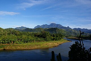
Andohahela National Park, in south-east Madagascar, is remarkable for the extremes of habitats that are represented within it. The park covers 760 km2 (293 sq mi) of the Anosy mountain range, the southernmost spur of the Malagasy Highlands and contains the last humid rainforests in the southern part of Madagascar.
In 2001, the Madagascar Ministry of Environment and Forests, in collaboration with the Wildlife Conservation Society (WCS), launched a program to create the 372,470 ha Makira Forest Protected Area. Formally established in 2012, Makira Natural Park is one of the largest of Madagascar’s protected areas and encompasses 372,470 hectares of strictly protected forest buffered by more than 350,000 hectares of community-managed forests. The Makira Natural Park is managed by WCS on behalf of the Government of Madagascar under a delegated management contract.

Andringitra National Park is a national park in the Haute Matsiatra region of Madagascar, 47 kilometres (29 mi) south of Ambalavao. The park was established in 1999 and is managed by the Madagascar National Parks Association. It was inscribed in the World Heritage Site in 2007 as part of the Rainforests of the Atsinanana.
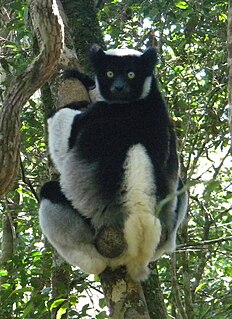
Andasibe-Mantadia National Park is a 155 square kilometre protected area, located about 150 km east of Antananarivo, consisting principally of primary growth forest in Alaotra-Mangoro Region in eastern Madagascar. The park's elevation ranges from 800–1260 meters, with a humid climate. Average annual precipitation is 1700 mm, with rainfall on 210 days of each year. This rainforest is habitat to a vast species biodiversity, including many endemic rare species and endangered species, including 11 lemur species. The park's two component parts are Mantadia National Park and Analamazoatra Reserve, which is best known for its population of Madagascar's largest lemur, the indri.
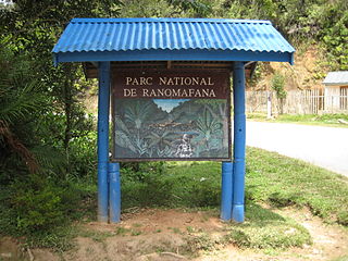
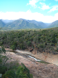
Ranomafana National Park is in the southeastern part of Madagascar in Haute Matsiatra and Vatovavy-Fitovinany. With more than 41,600 hectares of tropical rainforest, it is home to several rare species of flora and fauna including the golden bamboo lemur, the greater bamboo lemur, black and white ruffed lemur and Milne-Edwards sifaka, and over 130 species of frogs. Bird species including ground rollers, blue vangas, short-legged ground rollers and brown mesites can be seen. The park was established in 1991 with the purpose of conserving the unique biodiversity of the local ecosystem and reducing the human pressures on the protected area. It is part of the World Heritage Site Rainforests of the Atsinanana. Adjacent to the park is the Centre ValBio research station, established in 2003 and managed by Stony Brook University with a focus on biodiversity research, community health and education, environmental arts and reforestation.

The composition of Madagascar's wildlife reflects the fact that the island has been isolated for about 88 million years. The prehistoric breakup of the supercontinent Gondwana separated the Madagascar-Antarctica-India landmass from the Africa-South America landmass around 135 million years ago. Madagascar later split from India about 88 million years ago, allowing plants and animals on the island to evolve in relative isolation.
Marojejy National Park is a national park in the Sava Region of northeastern Madagascar. It covers 55,500 ha (214 sq mi) and is centered on the Marojejy Massif, a mountain chain that rises to an elevation of 2,132 m (6,995 ft). Access to the area around the massif was restricted to research scientists when the site was set aside as a strict nature reserve in 1952. In 1998, it was opened to the public when it was converted into a national park. It became part of the World Heritage Site known as the Rainforests of the Atsinanana in 2007. Despite its rugged terrain, poaching and selective logging are still persistent problems, particularly since the start of the 2009 political crisis in Madagascar. Mining, slash-and-burn agriculture, and wood collection also pose threats to the park and its wildlife.
Zahamena National Park is a national park of Madagascar. Established in 1997, it covers an area of 423 square kilometres (163.32 sq mi) out of a total protected area of 643 square kilometres (248.26 sq mi). It is part of a UNESCO World Heritage Site, Rainforests of the Atsinanana, inscribed in 2007 and consisting of 13 specific areas located within eight national parks in the eastern part of Madagascar. In 2001, Bird Life International assessed avifauna of 112 species of which 67 species are exclusively endemic to Madagascar.
Zahamena Reserve is a nature reserve in eastern Madagascar. This Strict Nature Reserve was inscribed as a World Heritage Site in 2007 as part of the Rainforests of the Atsinanana.
Anjanaharibe-Sud Reserve is a wildlife reserve in the north-east of Madagascar. The reserve was designated in 1958 and contains some of the last intact primary rainforest, along with several, rare and endemic animals and plants. The area was nominated to the UNESCO Tentative List of World Heritage Sites in Madagascar in 2008, as an extension of the rainforests of the Atsinanana.

The Littoral Rainforests of New South Wales is a group of fragmented and endangered ecological communities found by the coast in eastern Australia. Much of this seaside form has been destroyed by mining, tourist development or housing. It is threatened by extinction in the near future. 90% of the 433 sites are less than ten hectares in size. Littoral rainforest amounts to 0.6% of the rainforests in New South Wales.
Biosphere reserves are areas comprising terrestrial, marine and coastal ecosystems. The biosphere reserve title is handed over by UNESCO. Each reserve promotes solutions reconciling the conservation of biodiversity with its sustainable use. Biosphere reserves are 'Science for Sustainability support sites' – special places for testing interdisciplinary approaches to understanding and managing changes and interactions between social and ecological systems, including conflict prevention and management of biodiversity. Biosphere reserves are nominated by national governments and remain under the sovereign jurisdiction of the states where they are located. Their status is internationally recognized.