Related Research Articles

Lesotho, officially the Kingdom of Lesotho, is an enclaved country within the border of South Africa. Along with the Vatican City and San Marino, it is one of only three independent states completely surrounded by the territory of another country, and the only one outside the Italian peninsula and that is not a microstate. Lesotho is just over 30,000 km2 (11,583 sq mi) and has a population of around 2 million. Its capital and largest city is Maseru. The official language is Sesotho.
Telecommunications in Lesotho include radio, television, print and online newspapers, fixed and mobile telephones, and the Internet.

Maseru is the capital and largest city of Lesotho. It is also the capital of the Maseru District. Located on the Caledon River, Maseru lies directly on the Lesotho-South Africa border. Maseru had a population of 330,760 in the 2016 census. The city was established as a police camp and assigned as the capital after the country became a British protectorate in 1869. When the country achieved independence in 1966, Maseru retained its status as capital. The name of the city is a Sesotho word meaning "red sandstones".

The National University of Lesotho is in Roma, some 34 kilometers southeast of Maseru, the capital of Lesotho. The Roma valley is broad and is surrounded by a barrier of rugged mountains which provides magnificent scenery. The university enjoys a temperate climate with four distinct seasons. The governing body of the University is the Council and academic policy is in the hands of Senate, both Council and Senate being established by the Act.
Berea is a district of Lesotho. In the west, Berea borders on the Free State Province of South Africa. Domestically, it borders on the following districts: Leribe District in the north, Thaba-Tseka District in southeast and Maseru District in the south. Teyateyaneng is the capital of the district. It is also home to the Kome Cave Dwellings. It is also the only district in Lesotho which is not named after its capital.
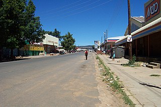
Hlotse is an important market town in Lesotho. It is situated on the Hlotse River, near the South African border. The town was founded in 1876 by a British missionary, Reverend John Widdicombe. It was a colonial centre until Lesotho gained its independence. The population in 2016 was 38,558.
Leribè is a district of Lesotho. It has an area of 2,828 km² and a population in 2016 of approximately 337,500. Hlotse is the capital or camptown of the district. The district has one additional town, namely Maputsoe. In the west, Leribe borders on the Free State Province of South Africa. Domestically, it borders Butha-Buthe District in the north, Mokhotlong District in the east, Thaba-Tseka District in southeast and Berea District in southwest.

Mafeteng is a district of Lesotho. It has an area of 2,119 km² and a population in 2016 of 178,222. Mafeteng is the capital or camptown, and only town in the district. In the west, Mafeteng borders on the Free State Province of South Africa. Domestically, it borders on the following districts Maseru District in the northeast and Mohale's Hoek District in the southeast.
Maseru is a district of Lesotho. Maseru is also the name of the district's capital, and is the only city in the district and also the capital of the country. It is the largest urban area in the country, and therefore the only city. The city of Maseru is located on Lesotho's western border with the Free State Province of South Africa, the frontier being the Caledon River. Maseru borders on Berea District in north, Thaba-Tseka District in the east, Mohale's Hoek District in south, and Mafeteng District in southwest.

Qacha's Nek is a district of Lesotho. Qacha's Nek is the capital or camptown, and only town in the district. In the south, Qacha's Nek borders on the Eastern Cape Province of South Africa, and it has a short border with KwaZulu-Natal Province in the far east. Domestically, it borders on Quthing District in southwest, Mohale's Hoek District in west and Thaba-Tseka District in the northern direction.

The Highveld is the portion of the South African inland plateau which has an altitude above roughly 1500 m, but below 2100 m, thus excluding the Lesotho mountain regions to the south-east of the Highveld. It is home to some of the country's most important commercial farming areas, as well as its largest concentration of metropolitan centres, especially the Gauteng conurbation, which accommodates one-third of South Africa's population.

The Setsoto Stadium is a multi-purpose stadium in Maseru, Lesotho. It is currently used mostly for football matches. The stadium holds 20,000. It is currently the home ground of the Lesotho national football team. It has been renovated and enlarged in 2010–2011.
The Central Bank of Lesotho is the central bank of Lesotho, in southern Africa. The bank is located in Maseru and its current governor is Dr. Retselisitsoe Matlanyane. The bank was established in 1978 as the Lesotho Monetary Authority.
The large-scaled mosaic-tailed rat is a species of rodent in the family Muridae. It is found in West Papua, Indonesia and Papua New Guinea.
Morija is a town in western Lesotho, located 35 kilometres south of the capital, Maseru. Morija is one of Lesotho's most important historical and cultural sites, known as the Selibeng sa Thuto— the Well-Spring of Learning. It was the site of the first French Protestant mission in Lesotho, founded in 1833. The town also houses the Morija Museum and Archives, well known for supporting research and preserving valuable records and documents of Lesotho's history.
Mafutseni is a town in central Eswatini. It is located to the northeast of Manzini and Hhelehhele at the junction of the MR3 route to Mpaka and the MR5 route to Mpisi.
Country Code: +266
International Call Prefix: 00
Trunk Prefix:

Setsoto Local Municipality is an administrative area in the Thabo Mofutsanyane District of the Free State in South Africa. The name is a Sesotho word meaning "beauty". Setsoto is headed by Ficksburg, followed by Senekal, Clocolan and Marquard. It is the getaway municipality to the Kingdom of Lesotho through Ficksburg. Setsoto is rich in agriculture as well as producing cherries.

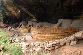
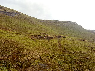
The Kome Caves are a group of cave dwellings made out of mud in the district of Berea, Lesotho 25 km east of Teyateyaneng.The caves are still inhabited by the descendants of the original people who built the caves. The site has been classified as a National Heritage Site.
Selloane Joyce Tsoaeli is a female track and field athlete from Lesotho who competes in the heptathlon and the high jump. She was the high jump gold medallist at the 2010 African Championships in Athletics and was a heptathlon bronze medallist at the same event. She also took heptathlon bronze at the 2011 All-Africa Games.
References
- Fitzpatrick, M., Blond, B., Pitcher, G., Richmond, S., and Warren, M. (2004) South Africa, Lesotho and Swaziland. Footscray, VIC: Lonely Planet.
Coordinates: 29°07′52″S27°59′52″E / 29.13122°S 27.997859°E
| This Lesotho location article is a stub. You can help Wikipedia by expanding it. |