Related Research Articles

Victoria Island is a large island in the Arctic Archipelago that straddles the boundary between Nunavut and the Northwest Territories of Canada. It is the eighth-largest island in the world, and at 217,291 km2 (83,897 sq mi) in area, it is Canada's second-largest island. It is nearly double the size of Newfoundland (111,390 km2 [43,010 sq mi]), and is slightly larger than the island of Great Britain (209,331 km2 [80,823 sq mi]) but smaller than Honshu (225,800 km2 [87,200 sq mi]). The western third of the island lies in the Inuvik Region of the Northwest Territories; the remainder is part of Nunavut's Kitikmeot Region. The population of 2,168 is divided among 2 settlements, the larger of which is in Nunavut and the other of which is in the Northwest Territories.

Kansas is a town in Walker County, Alabama, United States. It incorporated in 1956. At the 2010 census the population was 226, down from 260 in 2000.
Lowell is a town in Penobscot County, Maine, United States. The population was 368 at the 2020 census.
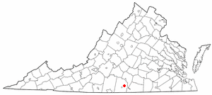
Scottsburg is a town in Halifax County, Virginia, United States. The population was 119 at the 2010 census, down from 145 at the 2000 census.

The Biobío Region is one of Chile's sixteen regions. With a population of 1.5 million, thus being the third most populated region in Chile, it is divided into three provinces: Arauco, Biobío and Concepción. The latter contains its capital and largest city, Concepción, a major city and metro area in the country. Los Ángeles, capital of the Biobío Province, is another important city in the region.

Cañete is a city and commune in Chile, located in the Arauco Province of the Biobío Region. It is located 135 km to the south of Concepción. Cañete is known as a "Historic City" as it is one of the oldest cities in the country. The Battle of Tucapel and Pedro de Valdivia's death happened near the city's current location. Cañete was also an important location in the Arauco War.

The Biobío River is the second largest river in Chile. It originates from Icalma and Galletué lakes in the Andes and flows 380 km to the Gulf of Arauco on the Pacific Ocean.

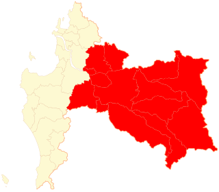
Arauco Province is one of three provinces of the Chilean region of Bío Bío. It spans a coastal area of 6,366 km2 (2,458 sq mi) just south of the mouth of the Biobío River, the traditional demarcation between the nation's major natural regions, Zona Central and Zona Sur. The province originally covered the once-independent indigenous territory of Araucanía, but this was afterward divided into four provinces. It is devoted largely to agricultural pursuits. The capital Lebu is situated on the coast about 90 km (56 mi) south of Concepción with which it is connected by rail.
Biobío Province is one of three provinces of the Chilean region of Biobío (VIII). Its capital is Los Ángeles. It is bounded on the north, west and south by the provinces of Concepción, Arauco and Malleco, respectively, and on the east by Argentina. It has an area of 14,987.9 km2 (5,787 sq mi) of well-wooded and mountainous country, and exports timber to a large extent. The population is 373,981 according to the census of 2012.
La Frontera is a name used in Chile to refer to the region around the Bío Bío River, or to the whole area between there and the Toltén River. The use of this latter definition is largely coterminous with the historical usage of Araucanía. The term was coined during the period when the region was the frontier of the Captaincy General of Chile, then a part of the Spanish Empire and later the Republic of Chile, with the Mapuche people inhabiting the Araucanía following their revolt in 1598. Subsequently, the Spanish Empire established a system of forts between the Bío Bío River and the Itata River, as well as some within the Araucanía. This system continued through the 18th century and into the 19th century.
Carampangue is a small town in Biobío Region, Chile. The town is approximately 50 kilometers south of the regional capital, Concepción, and a borders the towns of Arauco and Ramadillas. Carampangue is split by a highway, with the two parts respectively referred to by residents as Carampangue Viejo and Carampangue Nuevo. This division is not legal or administrative – it just makes giving directions easier.
Tucapel is a town and commune in the Bío Bío Province, Bío Bío Region, Chile. It was once a region of Araucanía named for the Tucapel River. The name of the region derived from the rehue and aillarehue of the Moluche people of the area between the Lebu and the Lleulleu Rivers, who were famed for their long resistance to the Spanish in the Arauco War. Tucapel is also the name of a famous leader from that region in the first resistance against the Spanish mentioned in Alonso de Ercilla's epic poem La Araucana. Formerly belonging to the Ñuble Province, in the Yungay Department. Near the town of Tucapel is the Plaza de San Diego de Tucapel. The capital of the commune is the town of Huépil, moving the municipality from Tucapel in 1967. In Mapudungun the name Huépil means "To seize or to take by force".
Arauco is a city and commune in Chile, located in Arauco Province in the Bío Bío Region. The meaning of Arauco means Chalky Water in Mapudungun. The region was a Moluche aillarehue. The Spanish settlements founded here during the Conquest of Chile were destroyed on numerous occasions by the Mapuche during the Arauco War.
Laraquete River is a small river in Arauco Province, Bío Bío Region of Chile. Its sources are in the Nahuelbuta Range and they flow west to its mouth at the bay of Arauco and the foot of the hill of Andalicán where there is located the town of Laraquete.
Antihuala or Antiguala,(mapudungum: anti: sun; huala: duck.) is a town in the Los Álamos commune of the Arauco Province, Bío Bío Region, of Chile. On February 5, 1558, during the Arauco War, Pedro de Avendaño with sixty men captured the Mapuche Caupolicán lonco of Pilmaiquén and the Mapuche Gran Toqui nearby Antihuala encamped with a small band of followers. He was taken back to Cañete, where its corregidor Alonso de Reinoso tried him for rebellion and executed him by impalement.

Carampangue River is a small river in Arauco Province, Bío Bío Region of Chile. It has its main source in the hill of la Piedra, South of the Heights of Purgatorio in the Nahuelbuta Range southwest of the town of Santa Juana, and it runs to the Northwest to empty into the Bay of Arauco north of Arauco, Chile. In its upper half it receives several streams from the forests of the Nahuelbuta Range that flow shortly after into a lower section that traverses a fertile and open valley, in which the Pedro de Valdivia's fort of San Felipe de Rauco or Old Arauco was first built, and the town of this name that was on the north shore. Its main tributaries are the riachuelos of Conumo and of Los Patos. In the lowest reach of the river it has about 12 to 14 kilometers that allows the navigation of small boats.

Bay of Arauco or Bahia de Araucan, is a bay located on the coast of the Arauco Province, of the Bío Bío Region of Chile. The bay, is between the mountains of the Nahuelbuta Range to the east and to the west the Santa Maria Island and northwest the Pacific Ocean. It is south and west of the Bay of Concepción and north of Arauco. The Bio Bio River flows into the bay at its northern end 10 km west of the city of Concepcion. On its shores are the cities of Lota, Colonel and Arauco.
Coordinadora Arauco-Malleco (CAM) is a radical, militant indigenous organization engaged in political violence in pursuit of attaining an autonomous Mapuche state in the territory they describe as Wallmapu.
References
28°07′S69°45′W / 28.117°S 69.750°W
- ↑ "Portal Municipalidad de Arauco - Ramadilla". municipalidaddearauco.cl. 2010-01-28. Archived from the original on 2010-01-28. Retrieved 2022-01-20.
| | This Biobío Region location article is a stub. You can help Wikipedia by expanding it. |