
Muzaffarpur is a city located in Muzaffarpur district in the Tirhut region of the Indian state of Bihar. It serves as the headquarters of the Tirhut division, the Muzaffarpur district and the Muzaffarpur Railway District. It is the fourth most populous city in Bihar.

Purnia is the fourth largest city of Bihar and is emerging as the largest economic hub in North Bihar. It serves as the administrative headquarters of both Purnia district and Purnia division in the Indian state of Bihar. It is well known for its favourable climate like Darjeeling and has an abundance of resources for human settlements and economic activities.

Saharsa is a city and municipal corporation in the Saharsa District in the eastern part of the state of Bihar, India. It is situated near the eastern banks of the Kosi River. It serves as the administrative headquarters for Saharsa District and is also the Divisional headquarters of the Kosi Division.
East Champaran is an administrative district in the state of Bihar in India.The district headquarters are located at Motihari. Prior to 1971, there was a single district called "Champaran". On 1 December 1971, the district was divided into 2 parts East Champaran and West Champaran. In early days the land of East Chamapran was ruled by different kingdoms as Videha, Sunga, Kanvas. It is also believed that Champaran used to be a major part of King Janak's empire. Mahatma Gandhi started his famous Satyagraha movement from here.
Bairgania is a town and notified area in the Sitamarhi district in the state of Bihar, India. Bairgania is one of the blocks of Sitamarhi districts and is a border of India that links Nepal via Rautahat District through a custom checkpoint. Bairgania is the first town of India that is located on the bank of the Bagmati River.It has a good government medical hospital and experience doctors such as alumni from PMCH.

Kahalgaon is a municipality Town and one of 3 sub-divisions of Bhagalpur district in the state of Bihar, India. It is located close to the Vikramashila, that was once a famous centre of Buddhist learning across the world, along with Nalanda during the Pala dynasty. The Kahalgaon Super Thermal Power Plant (KhSTPP) is located near the town (3 km).
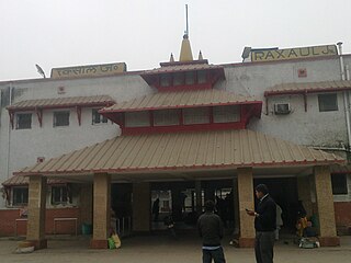
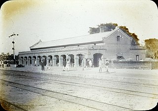
Raxaul is a sub-divisional town in the East Champaran district of the Indian state of Bihar. It is situated at the India-Nepal border with Birgunj city (Nepal). Raxaul is a major railway junction.
Khadda is a town, a nagar panchayat and a tehsil in Kushinagar district in the Indian state of Uttar Pradesh. It is situated approximately 8 kilometres (5.0 mi) from the border with Bihar and 18 kilometres (11 mi) from the India-Nepal border.

Koilwar or Koelwar is a nagar panchayat (town) and one of the 14 community development block in Bhojpur district in the Indian state of Bihar. As of 2011, the population of Koilwar town was 17,725, in 2,893 households. Koilwar lies on the Arrah-Patna highway (NH-922).

Sugauli is a city and a notified area in East Champaran district in the Indian state of Bihar. It is the setting for Rudyard Kipling's story "Rikki-Tikki-Tavi", and the place where a treaty was signed with Nepal in 1816.

Nasriganj is a nagar panchayat town and corresponding community development block situated in Rohtas District of Bihar, India. Located on the banks of the Son River, the town was a vibrant economic hub in the late 19th century. The town of Nasriganj had a population of 23,819, according to the 2011 Census of India, while the total population of Nasriganj block was 115,117. Besides the town of Nasriganj itself, the block consisted of 53 villages, of which 50 were inhabited and 3 were uninhabited.
Morsand is a village in Sitamarhi district, Bihar state, India. It is situated 18 km. to the southeast of the town of Sitamarhi on the banks of the river - Lakhandei, and is connected to the district headquarters via National Highway 77 Sitamarhi- Hajipur. The nearest railway stations are Sitamarhi and Muzaffarpur, and the nearest airport is in Patna. Now a new railway station is established in the village itself with the name "Runni Saidpur", which will be providing rail connectivity from this village to the rest of India.
Dheng is a village in Bihar, India. It is situated 25 km. away towards west from Sitamarhi on the bank of the Bagmati River, which is connected to the rest of the district center via broad-gauge rail network. It has: at the east side, the Maniyari and Vasant Gachhi Tola; to the west side, Bel, Bengahi and Adamwan; to the north side is Nepal and Jamla; and to the south is Gamhariya and Kharahia tola.

Mehsi is a High Deployment City and a municipality in the Purvi Champaran district in the Indian state of Bihar. It is a part of the Tirhut Division. The town is the entry point of the Purvi Champaran district. There are many smaller factories manufacturing buttons for the clothing Industry, although most of the population depends upon commercial business and Business agriculture.
Bhawanipur is near Areraj in the Indian state of Bihar. Bhawanipur is situated at the Bank of River Budhi-Gandak which falls in Ganga Patna. Bhawanipur is situated at a distance of about 40 km from Motihari, the district headquarters of East Champaran district. The National Highway NH 28 provides the closest route to Motihari. Bhawanipur falls under the jurisdiction of Sangrampur Police Station. Bhawani Pur village has two Panchayats: South Bhawani Pur and North Bhawani Pur. The famous Someshwar Shiv Madir, is located at Areraj which is at a 15-minute drive from Bhawanipur. Bhawani Pur belongs to the Kesaria Assembly and the Purvi Champaran Lok Sabha of Bihar.
Raghopur is a community development block in Vaishali district of Bihar. Situated between two streams of the Ganges river, it is a river island. It is connected to Patna by Pipa pul. Ancient name of Raghopur is Kotigram.
Laukaha is a very old border town and a Community development block in the district of Madhubani in the Indian state of Bihar. It is close to the border with Nepal and the Nepalese town of Thadi. The population of Laukaha is between 11, 000 and 15, 000.
Sita Kund is a Hindu pilgrimage site that honours the birthplace of the goddess, Sita. The Punaura Dham Janki Mandir is a Hindu pilgrimage site in Sitamarhi district, Bihar, which has an ancient Hindu temple. It is situated 5 km west of Sitamarhi City and a popular visitor's attraction.
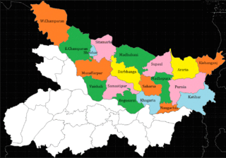
North Bihar is a term used for the region of Bihar, India, which lies north of the Ganga river.
Adapur is a block in East Champaran district of Bihar, India. Adapur railway station is located 40 kilometres (25 mi) north of Motihari, the district headquarters. The state capital Patna is 175 kilometres (109 mi) in south. Adapur is located on the India - Nepal border. There are many villagers Near Adapur town peoples come to buy their daily essential things.