
Talala is a town in Rogers County, Oklahoma, United States. The population was 273 at the 2010 census.

Gir National Park and Wildlife Sanctuary, also known as Sasan Gir, is a forest, national park, and wildlife sanctuary near Talala Gir in Gujarat, India. It is located 43 km (27 mi) north-east of Somnath, 65 km (40 mi) south-east of Junagadh and 60 km (37 mi) south-west of Amreli. It was established in 1965 in the erstwhile Nawab of Junagarh's private hunting area, with a total area of 1,410.30 km2 (544.52 sq mi), of which 258.71 km2 (99.89 sq mi) is fully protected as a national park and 1,151.59 km2 (444.63 sq mi) as wildlife sanctuary. It is part of the Khathiar-Gir dry deciduous forests ecoregion.
Jashubhai Dhanabhai Barad was an Indian politician. He was a member of the 14th Lok Sabha of India where he represented the Junagadh constituency of Gujarat. He was a former Cabinet Minister of water resources and irrigation of Gujarat state. He played a vital role in the development of Narmada and Ukai Dam Projects. He served his fourth term as member of legislative assembly representing Talala Gir Constituency of Gujarat until 2016.
The Dafer are a tribal community found in the state of Gujarat in India.
Jelogir is a village in Pa Alam, in the Central District of Pol-e Dokhtar County, Lorestan Province, Iran. At the 2006 census, its population was 535, in 115 families.

Hiran River is a river in Gujarat in western India, whose source is near the Sasa hills in Gir forest. Its drainage basin has a maximum length of 40 km (25 mi). The total catchment area of the basin is 518 km (322 mi). Its major tributaries are the Saraswati River and Ambakhoi stream, and many other unknown branches make this river almost complete near Talala town. Hiran is a major river system which supports a variety of wildlife ecological systems and human settlements. Kamleshwar Dam, often known as Hiran-1 and Umrethi Dam, are some of the major projects on the river. As the river flows from the western part of Gir forest, it is a major source of water for the forest's ecology and biodiversity for the whole year.

Gir Somnath is a district of Gujarat, India. It is located on the southern corner of the Kathiawar peninsula with its headquarters at the city of Somnath.
Talala is one of the 182 Legislative Assembly constituencies of Gujarat state in India. It is part of Gir Somnath district.
Gir Gadhada Taluka is a taluka of Gir Somnath district in the state of Gujarat, India. Before 2013 the area was part of Una Taluka, but it became a taluka in its own right with the creation of Gir Somnath District in August of that year. Gir Gadhada Taluka has population around 15,600. The village of Gir Gadhada became its administrative headquarters.
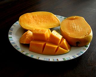
The 'Gir Kesar' mango, also called Kesar, is a mango cultivar grown in the foothills of Girnar in Gujarat, western India. The mango is known for its bright orange colored pulp and was given the geographical indication status in 2011. The biggest market of Gir Kesar is in Talala Gir known as a Mango Market Yard.
Talala (Gir) is a city and a taluka in Gir Somnath district in the Gujarat state of India, also known as capital of Gir.
Sasan Gir railway station is a small railway station in Gir Somnath district, Gujarat. Its code is SASG. It serves Sasan Gir village. The station consists of one platform. The platform is not well sheltered. It lacks many facilities including water and sanitation.
Ankolvadi Gir is a village in the Talala, Gujarat taluka and Gir Somnath district in the west of Gujarat, India. As of 2018 it had a population near 15,000. the village is located at a hill, and it has a natural atmosphere. The people of Ankolwadi Gir are mostly connected to the business of KESAR MANGO farming. Ankolwadi Gir is located near Jungle of Gir, therefore lions and leopards come to the village for hunting often. It is an attractive place for planning a holiday because of its atmosphere and other attractions like jungle and lion
Jambur is a village in Gir Somnath district of Gujarat, India. It is located near Gir Forest National Park, 68 kilometres (42 mi) south of the district headquarters at Junagadh and 377 kilometres (234 mi) from the state capital of Gandhinagar. Jambur is known for being home for centuries to some members of the African-origin Siddi tribe.
Mahobatpara is a village / panchayat located in the Gir Gadhada Taluka of Gir Somnath district in Gujarat State, India. Earlier, until August 2013, Mahobatpara was part of Una Taluka and Junagadh district. The latitude 20.931475 and longitude 71.082764 are the geo-coordinate of the Village Mahobatpara. Gandhinagar is the state capital of Mahobatpara village which is located around 350 kilometres away from Mahobatpara.
Dron is a village / panchayat, located in the Gir Gadhada Taluka of Gir Somnath district in Gujarat State, India. Earlier, until August 2013, Dron was part of Una Taluka and Junagadh district. The latitude 20.928161 and longitude 70.949985 are the geo-coordinate of the Village Dron. Gandhinagar is the state capital of Dron village which is located around 362 kilometres away from Dron.
Talala Junction railway station is a railway station on the Western Railway network in the state of Gujarat, India. Talala Junction railway station is 25 km far away from Veraval Junction railway station. Passenger trains halt here.
Prachi Road Junction railway station is a railway station in the Bhavnagar railway division of the Western Railway. It is a junction railway station on Veraval–Prachi–Kodinar line and Veraval–Prachi–Delvada line. It is located at Panikotha village, Talala taluka, Gir Somnath district, Gujarat, India. It serves Prachi village, located 12 km away, in Sutrapada taluka and surrounding villages. Only passenger trains halt here.

