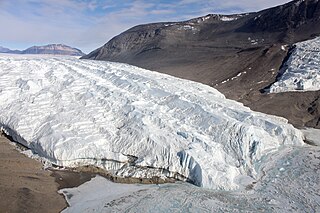
The Taylor Glacier is a glacier in Antarctica about 35 nautical miles long, flowing from the plateau of Victoria Land into the western end of Taylor Valley, north of the Kukri Hills. It flows to the south of the Asgard Range. The middle part of the glacier is bounded on the north by the Inland Forts and on the south by Beacon Valley.
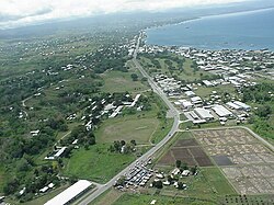
Vura is a suburb in Honiara, Solomon Islands located East of the main center.
King George is a suburb in Honiara, Solomon Islands located East of the main center and west of Henderson
Upper Tasahe is a suburb of Honiara, Solomon Islands located west of the main center and south of White River.
Tuvaruhu is a suburb of Honiara, Solomon Islands, south of Point Cruz.
East Kola'a Ridge is a suburb of Honiara, Solomon Islands and is located east of Chinatown.
Ferakusia is a suburb of Honiara, Solomon Islands, south of Chinatown.
Kola'ale is a suburb of Honiara, Solomon Islands and is located South of Kukum.
Fishing Village/Kukum is a suburb of Honiara, Solomon Islands, and is located east of the main center and west of Panatina.
Gilbert Camp is a suburb of Honiara, Solomon Islands and is located South of Kukum.
Panatina is a suburb of Honiara, Solomon Islands and is located West of the main center.
Naha is a suburb of Honiara, Solomon Islands and is located South of Kukum.
Baranaba is a suburb of Honiara, Solomon Islands and is located South of Ranadi.
Nggeukama is a suburb of Honiara, Solomon Islands and is located West of Lungga Point.
Lungga Point is a suburb of Honiara, Solomon Islands and is located East of the main center and North-West of Honiara International Airport.

Lungga is a suburb of Honiara, Solomon Islands and is located east of the main center on Lungga Point.
Betikama is a suburb of Honiara, Solomon Islands and is located South of Lungga Point.
NZ Camp is a suburb of Honiara, Solomon Islands and is located South-East of Honiara International Airport.
Henderson West is a suburb of Honiara, Solomon Islands and is located West Honiara International Airport.
Henderson East is a suburb of Honiara, Solomon Islands and is located East of Honiara International Airport.