The Western Hemisphere is a geographical term for the half of Earth which lies west of the prime meridian and east of the antimeridian. The other half is called the Eastern Hemisphere.

Finnøy is an island municipality in Rogaland county, Norway. It is located in the traditional district of Ryfylke. The administrative centre of the municipality is the village of Judaberg.

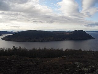
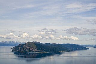
Alsta is an island in the municipalities of Alstahaug and Leirfjord in Nordland county, Norway. The island is surrounded by the Vefsnfjorden to the east, the Leirfjorden to the north, and the Alstenfjorden to the south and west. The eastern part of the island is dominated by the Seven Sisters mountain range which has five mountains that are more than 1,000 metres (3,300 ft) tall, while the western part of the island is relatively flat and it is the location of the town of Sandnessjøen and the village of Søvika in the south.
Ombo is the largest island in the Ryfylke region on the southwestern coast of Norway, and is the second largest island in Rogaland county. The 57.5-square-kilometre (22.2 sq mi) island of Ombo is divided between the municipalities Hjelmeland and Finnøy. There are several villages on the island including Jørstadvåg, Atlatveit, and Eidssund in the western part of the island which belongs to Finnøy municipality. The villages of Tuftene, Skipavik, Skår, and Vestersjø are located on the southeastern part of the island which belongs to Hjelmeland municipality. Jørstad Church is located in the village of Jørstadvåg.

Boknafjord or Boknafjorden is a fjord located in Rogaland county, Norway. The huge fjord lies between the cities Stavanger and Haugesund, and the main part of the fjord is shared between the municipalities of Kvitsøy, Rennesøy, Finnøy, Tysvær, Bokn, and Karmøy. There are dozens of smaller fjords that branch off the main part of the fjord, reaching most municipalities in the county. At its longest, the Boknafjord reaches about 96 kilometres (60 mi) into the mainland at the innermost point of the Hylsfjorden. Other notable branches include the Saudafjorden, Sandsfjorden, Vindafjorden, Hervikfjorden, Førresfjorden, Erfjorden, Jøsenfjorden, Årdalsfjorden, Idsefjorden, Høgsfjorden, Lysefjorden, and Gandsfjorden.

Sotra or Store Sotra is the name of a large island in Hordaland county, Norway, located just west of the city of Bergen. It is part of a pair of islands called Sotra that are part of a large archipelago stretching from Fedje southwards along the coast of Norway. The larger island of the two is Store Sotra, and the smaller of the two is Litlesotra. Roughly 30,500 people live on the two islands of Sotra.

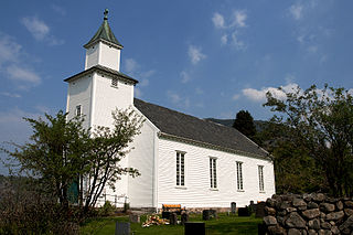
Sjernarøy is a former municipality in Rogaland county, Norway. The island municipality existed from 1868 until its dissolution in 1965. The municipality was located in the Boknafjorden in the present-day municipality of Finnøy. The administrative centre of the municipality was located on the island of Kyrkjøy, where the Sjernarøy Church is located.
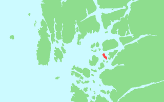
Judaberg is the administrative centre of Finnøy municipality in Rogaland county, Norway. The village is located on the eastern shore of the island of Finnøy. The island is located on the south side of the Boknafjorden, northeast of the large city of Stavanger.

Tysnesøya or Tysnesøy is an island in Tysnes municipality in Hordaland county, Norway. The 198-square-kilometre (76 sq mi) island makes up the vast majority of the island municipality of Tysnes. The tallest point on the island is the 753-metre (2,470 ft) tall mountain Tysnessåto.
Dyrøya is an island in Dyrøy Municipality in Troms county, Norway. The 53-square-kilometre (20 sq mi) island is located between the large island of Senja and the mainland of Norway. The Dyrøysundet strait lies to the east of the island and the Tranøyfjorden lies to the north and west. The island of Andørja lies about 7 kilometres (4.3 mi) south of Dyrøya.
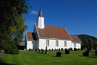
Jelsa is a former municipality in Rogaland county, Norway. The 130-square-kilometre (50 sq mi) municipality existed from 1838 until 1965. It encompassed area in the present-day municipalities of Suldal, Hjelmeland, and Finnøy that surround the Sandsfjorden. The administrative centre was the village of Jelsa, where Jelsa Church is located.

Finnøy is an island in Finnøy municipality in Rogaland county, Norway. The 25-square-kilometre (9.7 sq mi) island is one of the largest in the island municipality. The administrative centre, Judaberg, is located on the eastern shore of the island. The island is located on the southern side of the Boknafjorden, about 20 kilometres (12 mi) northeast of the city of Stavanger. The village of Hesby, on the western coast, is a historical seat of power dating back to the Middle Ages. Hesby is also the site of Hesby Church which dates back to around the year 1100.
Nedstrand is a former municipality in Rogaland county, Norway. The 119-square-kilometre (46 sq mi) municipality was located along the Nedstrandfjorden, an inner branch off the main Boknafjorden. The municipality encompassed the majority of the Nedstrand peninsula. Originally it also included the Sjernarøyane islands and the western part of the island of Ombo in the fjord to the south. The administrative centre of the municipality was the village of Nedstrand. Nedstrand Church is located in Hindaråvåg, a small village just west of Nedstrand village. Today, the area is part of the large municipality of Tysvær.

Karmøy is an island in the northwestern part of Rogaland county, Norway. The 176.8 square kilometres (68.3 sq mi) island makes up the majority of the municipality of Karmøy, along with the islands of Feøy, some smaller surrounding islands, and part of the mainland south of Haugesund. It is the largest island in Rogaland county. The island is separated from the mainland by the Karmsundet strait. The Boknafjorden lies to the south and southeast of the island. The Sirafjorden lies to the west, separating Karmøy from the islands of Utsira and Feøy.
Sjernarøyane is an island group in Finnøy municipality in Rogaland county, Norway. The islands are located in the Nedstrandsfjorden, west of the large island of Ombo and north of the large island of Finnøy. As of 2014, the islands were home to 365 residents. The islands were historically part of the municipality of Sjernarøy before merging into the municipality of Finnøy in 1965. The Aubøsund strait, which runs between the islands of Aubø and Bjergøy was a historically important trading post.
Halsnøya is an island in Finnøy municipality in Rogaland county, Norway. The 4.9-square-kilometre (1.9 sq mi) island is the largest island in of the Fisterøyene archipelago. Halsnøya is located south of the island of Ombo, southeast of the Sjernarøyane islands, east of the island of Finnøy, northeast of the island of Fogn, and west of the island of Randøy. The island is only accessible by boat, with regular ferry service from the nearby islands and to the mainland.
Fister is a former municipality in Rogaland county, Norway. The 47-square-kilometre (18 sq mi) municipality existed from 1884 until 1965. It was located in the present-day municipalities of Finnøy and Hjelmeland. The administrative centre of the municipality was the village of Fister, where the Fister Church is located. The municipality encompassed the western coast of mainland along the Fisterfjorden plus the islands to the west of the mainland, including the western part of Randøy and Halsnøya.