Related Research Articles

Irrigation is the practice of applying controlled amounts of water to land to help grow crops, landscape plants, and lawns. Irrigation has been a key aspect of agriculture for over 5,000 years and has been developed by many cultures around the world. Irrigation helps to grow crops, maintain landscapes, and revegetate disturbed soils in dry areas and during times of below-average rainfall. In addition to these uses, irrigation is also employed to protect crops from frost, suppress weed growth in grain fields, and prevent soil consolidation. It is also used to cool livestock, reduce dust, dispose of sewage, and support mining operations. Drainage, which involves the removal of surface and sub-surface water from a given location, is often studied in conjunction with irrigation.
The Southeastern Anatolia Project is a multi-sector integrated regional development project based on the concept of sustainable development for the 9 million people (2005) living in the Southeastern Anatolia region of Turkey. According to the Southeastern Anatolia Project Regional Development Administration, the aim of the GAP is to eliminate regional development disparities by raising incomes and living standards and to contribute to the national development targets of social stability and economic growth by enhancing the productive and employment generating capacity of the rural sector. The total cost of the project is over 100 billion Turkish lira (TL), of which 30.6 billion TL of this investment was realized at the end of 2010. The real investment was 72.6% for the end of 2010. The project area covers nine provinces which are located in the basins of the Euphrates and Tigris and in Upper Mesopotamia.

The Indian rivers interlinking project is a proposed large-scale civil engineering project that aims to effectively manage water resources in India by linking Indian rivers by a network of reservoirs and canals to enhance irrigation and groundwater recharge, reduce persistent floods in some parts and water shortages in other parts of India. India accounts for 18% of the world population and about 4% of the world's water resources. One of the solutions to solve the country's water woes is to link the rivers and lakes.
Water resources and irrigation infrastructure in Peru vary throughout the country. The coastal region, an arid but fertile land, has about two-thirds of Peru’s irrigation infrastructure due to private and public investment aimed at increasing agricultural exports. The Highlands and Amazon regions, with abundant water resources but rudimentary irrigation systems, are home to the majority of Peru's poor, many of whom rely on subsistence or small-scale farming.
Mexico, a classified arid and semi-arid country, has a total land area of 2 million square kilometres, 23% of which is equipped for irrigated agriculture. The agricultural sector plays an important role in the economic development of the country accounting for 8.4 of agricultural gross domestic product (GDP) and employing 23% of the economically active population. Irrigated agriculture contributes about 50% of the total value of agricultural production and accounts for about 70% of agriculture exports. Mexico's government initiated a number of structural reforms in the water sector aimed to introduce modern water management and irrigation.
Irrigation in Brazil has been developed through the use of different models. Public involvement in irrigation is relatively new while private investment has traditionally been responsible for irrigation development. Private irrigation predominates in the populated South, Southeast, and Center-West regions with most of the country’s agricultural and industrial development. In the Northeast region, investments made by the public sector seek to stimulate regional development in an area prone to droughts and with serious social problems. These different approaches have resulted in diverse outcomes. Of the 120 million hectares (ha) that are potentially available for agriculture, only about 3.5 million ha are under irrigation, although estimates show that 29 million ha are suitable for this practice.

The Dahla Dam, also known as Arghandab Dam and Kasa, is located in the Shah Wali Kot District of Kandahar Province in Afghanistan, approximately 40 km (25 mi) northeast of the provincial capital Kandahar. Its name derives from Dahla, which is the historical name of the area where the dam was built. It is the second largest dam in Afghanistan after the Kajaki Dam in neighboring Helmand Province. In 2019, the Afghan government planned to spend $450 million in upgrading the dam. The project includes raising the dam's walls by around 13 meters so the reservoir could hold nearly a billion cubic meters of fresh water and installing three turbines to produce 22 megawatts (MW) of electricity.
Irrigation in the Dominican Republic (DR) has been an integral part of DR agricultural and economic development in the 20th century. Public investment in irrigation has been the main driver for irrigation infrastructural development in the country. Irrigation Management Transfer to Water Users Associations (WUAs), formally started in the mid-1980s, is still an ongoing process showing positive signs with irrigation systems in 127,749 ha, being managed by 41,329 users. However, the transfer process and the performance of WUAs are still far from ideal. While WUAs show a significant increase in cost recovery, especially when compared to low values in areas under state management, a high subsidy from the government still contributes to cover operation and maintenance costs in their systems.

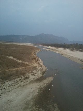
The Sharda River is the downstream of Kali River that originates in the northern Uttarakhand state of India in the Great Himalayas on the eastern slopes of Nanda Devi massif, at an elevation of 3,600 m (11,800 ft) in the Pithoragarh district. It then flows between the Nepal and India border. Descending, it enters the Indo-Gangetic Plain at Brahmadev Mandi in Nepal, where it expands above the Sharda Barrage. From that point onward, it is known as the Sharda River. The river proceeds southeastward into India through northern Uttar Pradesh before merging with the Ghaghara River southwest of Bahraich, covering a distance of approximately 300 miles.
Irrigation is the artificial exploitation and distribution of water at project level aiming at application of water at field level to agricultural crops in dry areas or in periods of scarce rainfall to assure or improve crop production.
This article discusses organizational forms and means of management of irrigation water at project (system) level.
Water resources management in modern Egypt, is a complex process that involves multiple stakeholders who use water for irrigation, municipal and industrial water supply, hydropower generation and navigation. In addition, the waters of the Nile support aquatic ecosystems that are threatened by abstraction and pollution. Egypt also has substantial fossil groundwater resources in the Western Desert.
The Kankai River is a trans-boundary river flowing through the hills of Ilam and the plains of the Jhapa District in Nepal. It begins at the confluence of the Mai Khola and Deb Mai Khola rivers.
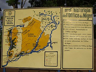
The Office du Niger is a semi-autonomous government agency in Mali that administers a large irrigation scheme in the Ségou Region of the country. Water from the Niger River is diverted into a system of canals at the Markala dam 35 kilometres (22 mi) downstream of Ségou. The water is used to irrigate nearly 100,000 hectares (390 sq mi) of the flat alluvial plains to the north and northeast of Markala that form part of the Delta mort. Although the French colonial administration constructed the system to produce cotton for the textile industry, the main agricultural product is now rice. Around 320,000 tons are grown each year representing 40 percent of the total Malian production. Large quantities of sugar cane are also grown in joint ventures between a Chinese company and the Malian state. The irrigation scheme uses 2.7 km3 (0.65 cu mi) of water each year corresponding to around 10 percent of the total flow of the Niger River.

Irrigation in India includes a network of major and minor canals from Indian rivers, groundwater well based systems, tanks, and other rainwater harvesting projects for agricultural activities. Of these groundwater system is the largest. In 2013–14, only about 36.7% of total agricultural land in India was reliably irrigated, and remaining 2/3 cultivated land in India is dependent on monsoons. 65% of the irrigation in India is from groundwater. Currently about 51% of the agricultural area cultivating food grains is covered by irrigation. The rest of the area is dependent on rainfall which is most of the times unreliable and unpredictable.
The Lower Sharda Barrage, is a dam nearly 28 km from Lakhimpur city in Uttar Pradesh, India.
Iranamadu Tank is an irrigation tank in northern Sri Lanka, approximately 3 mi (5 km) south east of Kilinochchi.
In 1977 the Board of Governors of the World Bank approved Bura Irrigation and Settlement Project (BISP) in Kenya. The project area is situated just South of the Equator in the Lower Tana Basin. It lies on the west bank of the Tana River and falls within the administrative area of Tana River County. The project was an ambitious attempt of the government of Kenya, the World Bank and a few other donors to develop a remote area, create employment for thousands of people with a reasonable income and earn foreign exchange. Bura project would develop about 6,700 net irrigated ha over a 5 1⁄2 year period and settle on smallholdings about 5,150 landless poor families selected from all parts of Kenya. Physical and social infrastructure would be provided to support the settler and satellite population, expected to reach a total of 65,000 persons by 1985. The total cost of the project was estimated at 92 million dollars in 1977 prices. Actual construction started in 1978. During implementation the costs exploded from $17,500/= per family to $55,000/=, a new record for the World Bank. The largest cost increase was for the irrigation network (615%). The donors were not willing and the government was not able to raise the additional funds and subsequently the size of the project was scaled down from 6,700 ha to 3,900 and later to 2,500 ha, although the irrigation structures were completed for 6,700 ha. In this period 2,100 landless households from all over Kenya were settled in the scheme. They were allocated two plots of 0.625 ha and a garden of 0.05 ha. Each year they were to grow 1.25 ha cotton and 0.625 maize intercropped with cowpeas. Soon it was evident that the project would fail to achieve its objectives. Job creation was only 40% of the target, the economic rate of return was negative and the annual operating and maintenance costs exceeded the benefits. Even with net farm incomes of about 40% of the appraisal estimates in real terms, annual government subsidies amounted to about 1,000 dollars per settler. The project had an unreliable water supply and many buildings had foundation problems. After cotton crop failures due to pests in 1990 the project came virtually to a standstill as the management lacked the funds to finance cotton and maize crops. Most settlers deserted and only the ones with nowhere to go remained in the scheme, living on famine relief and odd jobs. In the period 1993-2005 a number of times the government tried to revive a number of timesthe project, but all in vain. After 2005, rehabilitation and crop growing started in phases and since 2009-10 the tenants have been growing crops, although the cropping pattern comed down to no more than 50% of the projected crop intensity and the settlers have low incomes, if any. This is partly caused by the fact that the original cash crop, cotton, is no longer a profitable crop.
National Pride Projects are a set of infrastructure projects by the government of Nepal based on the proposal by the National Planning Commission.
Bheri Babai Diversion Multipurpose Project (BBDMP) is a multi-basin irrigation cum hydropower project lying in Surkhet District of Karnali Province in Mid-West Nepal. The water is diverted from the Bheri River and discharged to Babai River. The project aims to irrigate 51,000 ha of land in Banke and Bardiya District throughout the year. The elevation difference between the intake and irrigation area provided an opportunity to install 46.8 MW firm electricity. The project has a tunnel 12208 meters long that was constructed using a tunnel boring machine (TBM) for the first time in Nepal. The project is owned by the Ministry of Energy, Water Resources and Irrigation. Construction of the project commenced in 2015 and is expected to complete in 2023. The project is estimated to cost NPR 30,00,00,00,000.
Babai Irrigation Project is an irrigation project in western Nepal which aim to irrigate 36,000 ha of land by using water of Babai River. The project has been listed as the National Pride Projects of Nepal and is implemented by the Ministry of Energy, Water Resources and Irrigation (Nepal). The project aims to irrigate about 21,000 ha and 15,000 ha in the eastern and western side of the river respectively. The project cost is estimated to be about NPR 17,340,000,000.
References
- 1 2 3 "परिचय" [Introduction]. rjkip.gov.np.
- ↑ "The Rising Nepal: Rani-Jamara Irrigation Main Canal on trial" . Retrieved 2020-07-03.
- ↑ "Farmers in Tikapur see increased productivity" . Retrieved 2020-07-03.