
The Au Sable River in Michigan, United States runs approximately 138 miles (222 km) through the northern Lower Peninsula, through the towns of Grayling and Mio, and enters Lake Huron at Au Sable. It is considered one of the best brown trout fisheries east of the Rockies and has been designated a blue ribbon trout stream by the Michigan Department of Natural Resources. In French, au sable literally means "at the sand." A 1795 map calls it the Beauais River.

The St. Joseph River is an 86.1-mile-long (138.6 km) tributary of the Maumee River in northwestern Ohio and northeastern Indiana in the United States, with headwater tributaries rising in southern Michigan. It drains a primarily rural farming region in the watershed of Lake Erie.

Rapid River is an unincorporated community in Masonville Township, Delta County in the U.S. state of Michigan.

The Cass River is a 61.5-mile-long (99.0 km) river in the Thumb region of the U.S. state of Michigan. It drains large portions of Sanilac and Tuscola counties and smaller portions of Genesee, Huron, Lapeer, and Saginaw counties.
Rapid City is an unincorporated community and census-designated place in Clearwater Township, Kalkaska County, Michigan, United States. Its population was 1,352 as of the 2010 census. The community is located on the Rapid River.
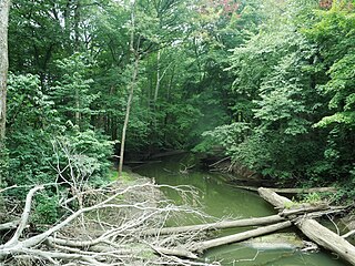
Carp River is a 40.2-mile-long (64.7 km) river in Chippewa and Mackinac counties in the U.S. state of Michigan. 21.7 miles (34.9 km) of the river were added to the National Wild and Scenic Rivers System in 1992.

The Ontonagon River is a river flowing to Lake Superior on the western Upper Peninsula of Michigan in the United States. The main stem of the river is 25 miles (40 km) long and is formed by a confluence of several longer branches, portions of which have been collectively designated as a National Wild and Scenic River. Several waterfalls occur on the river including Agate Falls and Bond Falls.
Paint Creek is a 16.8-mile-long (27.0 km) stream in the U.S. state of Michigan, located in northern Oakland County and rising in Brandon Township in the northern part of the county. The creek drains through a series of lakes that lead into Lake Orion. Paint Creek continues as the outflow from the east end of Lake Orion in downtown Lake Orion. It flows southeastward through Oakland Township and Rochester Hills into the Clinton River in Rochester.
The Tittabawassee River is a stream that flows in a generally southeasterly direction through the Lower Peninsula of the U.S. state of Michigan. The river begins at Secord Lake in Clement Township, at the confluence of the East Branch and the Middle Branch. From there it flows through Gladwin, Midland and Saginaw counties where, as a major tributary of the Saginaw River, it flows into it at Saginaw. Its tributaries include the Chippewa, Pine, Molasses, Sugar, and Tobacco rivers.
The Whitefish River is an 11.9-mile-long (19.2 km) river on the Upper Peninsula of the U.S. state of Michigan. The mouth of the river is in Delta County at 45°54′34″N86°58′01″W on the Little Bay De Noc of Lake Michigan. The main branch of the river is formed by the confluence of the east and west branches at 46°03′25″N86°52′17″W.
The Galien River is a 30.0-mile-long (48.3 km) stream in the southwest region of the U.S. state of Michigan. The river begins at the outlet of Dayton Lake and flows in a predominantly westerly direction until it enters southeastern Lake Michigan at New Buffalo. The South Branch Galien River rises just north of the border with Indiana, at the confluence of Spring Creek and the Galena River, the latter rising in LaPorte County, Indiana.
Rapid River is a 17.0-mile-long (27.4 km) river in Kalkaska County in the U.S. state of Michigan. The river empties into the Torch River at the community of Torch River just south of Torch Lake.
The Rapid River is a 4.5-mile-long (7.2 km) river on the Upper Peninsula of the U.S. state of Michigan. It rises in Bergland Township and flows mostly east into the Big Iron River.

The Prairie River is a small river that flows 54 miles (87 km) through Branch and St. Joseph counties in Michigan. The river rises at 41°48′20″N85°00′54″W in northern Kinderhook Township in Branch County, and flows west-northwest into the St. Joseph River at 41°54′45″N85°38′21″W just south of the city of Three Rivers, Michigan.

The Ocqueoc River is stream in Presque Isle County in the northeastern part of the lower peninsula in the U.S. state of Michigan. It is 34.2 miles (55.0 km) long and encompasses a watershed of approximately 94,394 acres (382.00 km2).
The Little Rapid River is a 4.6-mile-long (7.4 km) stream in Kalkaska County, Michigan, in the United States. It is a tributary of the Rapid River, part of the Elk River Chain of Lakes Watershed flowing to Lake Michigan.
Sturgeon River is a 63.6-mile-long (102.4 km) river in the U.S. state of Michigan, flowing mostly southward through Alger County and Delta County counties on the Upper Peninsula.

Indian River is a 59.1-mile-long (95.1 km) tributary of the Manistique River on the Upper Peninsula of Michigan in the United States. It rises out of Hovey Lake at 46°17′36″N86°42′20″W on Hiawatha National Forest land in Alger County and flows south and east through a lake district and on through Schoolcraft County. The river flows into the 8,659 acre (35 km²) Indian Lake at 46°17′36″N86°42′20″W and flows out at 45°59′30″N86°17′15″W. It then flows east and south about 2.5 miles where it merges with the Manistique River, which then flows through Manistique and into Lake Michigan at 45°56′56″N86°14′45″W.
Sturgeon River is a 106-mile-long (171 km) river in Baraga County and Houghton counties in the U.S. state of Michigan. 25.0 miles (40.2 km) of the river were added to the National Wild and Scenic Rivers System in 1992.
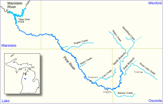
The Pine River, formerly known as the South Branch Manistee River, is a 53.6-mile-long (86.3 km) tributary of the Manistee River in the U.S. state of Michigan. It forms at the confluence of the North Branch and East Branch of the Pine River in northwest Osceola County, flows southwest, then west and north through the northeast corner of Lake County and into southwest Wexford County, emptying into the Tippy Dam Pond on the Manistee River in Manistee County. The Pine River watershed drains an area of 265 square miles (690 km2).


