This article needs additional citations for verification .(February 2022) |
Ras Menheli is a point in Yemen on the coast of Bab-el-Mandeb close to the island of Perim. [1]
This article needs additional citations for verification .(February 2022) |
Ras Menheli is a point in Yemen on the coast of Bab-el-Mandeb close to the island of Perim. [1]

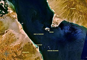
The Bab-el-Mandeb, or the Gate of Grief, is a strait between Yemen on the Arabian Peninsula, Djibouti, and Eritrea in the Horn of Africa. It connects the Red Sea to the Gulf of Aden.

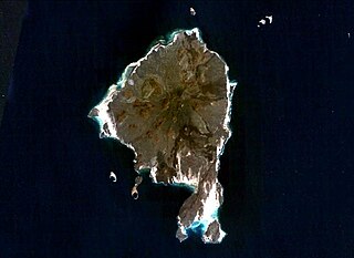
Perim, also called Mayyun in Arabic, is a volcanic island in the Strait of Mandeb at the south entrance into the Red Sea, off the south-west coast of Yemen and belonging to Yemen. It administratively belongs to Dhubab District or Bab al-Mandab District, Taiz Governorate. The island of Perim divides the strait of Mandeb into two channels.
Zuqar Island is an island in the Red Sea that belongs to Yemen. It lies between the coasts of mainland Yemen and Eritrea, near the Bab-el-Mandeb straits which connect the Red Sea to the Gulf of Aden. Despite its proximity to the African continent, Zuqar Island is considered a part of Asia because it sits on the Asian continental shelf. It is appropriately 130 km2.
The Bab Iskender (Arabic: باب اسكندر Iskander's Strait, also variously known as the Eastern strait, the small strait, the narrow pass or the small pass, is the eastern section of the Bab-el-Mandeb straits, which separates Ras Menheli, Yemen, on the Arabian Peninsula from Ras Siyyan, Djibouti, on the Horn of Africa. The strait is 2 miles wide and 16 fathoms deep. The Yemeni island of Perim divides the strait into two channels, Bab Iskender and Dact-el-Mayun respectively.
The Dact-el-Mayun, also known as the Western strait, the large strait, the large pass or the wide pass, is the western section of the Bab-el-Mandeb straits, which separates Ras Menheli, Yemen, on the Arabian Peninsula from Ras Siyyan, Djibouti, on the Horn of Africa. The strait has a width of about 16 miles (26 km) and a depth of 170 fathoms (310 m). The Yemeni island of Perim divides the strait into two channels, Bab Iskender and Dact-el-Mayun respectively.

Khôr ʽAngar is a town in the northern Obock Region of Djibouti. It is situated on the west coast of the Bab el Mandeb Strait. The town is served by Herkale Airport, a desert airstrip 7 kilometres (4 mi) northwest.
Ambouli is a southern suburb of Djibouti, Djibouti.
Herkale Airport is an airstrip 7 kilometres (4 mi) northwest of the hamlet of Khôr ‘Angar in Djibouti. Khôr ‘Angar is by the Bab-el-Mandeb strait, the entrance to the Red Sea.

Ergalatax martensi is one of the most common and the historic species of sea snail, a marine gastropod mollusk in the family Muricidae, the murex snails or rock snails. Ergalatax Martensi are commonly found within the deep blue sea and some time it gets floated to sea sand due to sea level changes.

MSC Prestige is a container ship that collided with a large tanker MV Samco Europe, off the Red Sea traffic separation scheme of Bab-el-Mandeb on 7 December 2007. Both vessels suffered severe damage at their bows and had to undergo major repairs.
Barbaria was the name used by the ancient Greeks for littoral northeast Africa. The corresponding Arabic term, bilad al-Barbar, was used in the Middle Ages. The name of Barbaria is preserved today in the name of the Somali city of Berbera, the city known to the Greeks as Malao.
Hisn Murad or Murad is a small coastal fishing village in the Lahij Governorate of the Bab-el-Mandeb in the south-western tip of Yemen overlooking the Gulf of Aden. It lies on the border of the Lahij Governorate and the Ta'izz Governorate. The island of Perim lies just off the coast. It is connected by road to Dhubab and Mocha in the north and As Suqayyan, Al Bahiyah, Am Juhar and Aden in the east.

The Djiboutian Navy is the naval service branch of the Djibouti Armed Forces. It is responsible for securing Djibouti's territorial waters and 314-kilometre (195 mi) seaboard as well as supporting army operations. The primary objective of the navy is to safeguard the nation's maritime borders, act to deter or defeat any threats or aggression against the territory, people or maritime interests of Djibouti, both in war and peace. Through joint exercises and humanitarian missions, including disaster relief, the Djiboutian Navy promotes bilateral relations between nations. It has a fleet of gunboats, fast missile boats and support, training, which can be deployed to defend the territorial waters and coastline of Djibouti as well as protect tankers passing through the Bab-el-Mandeb strait.
Moulhoule is a town in the northern Obock region of Djibouti. It is situated on the west coast of the Red Sea, at its southern entrance. It is located on the RN-15 National Highway, which connects it to Obock, located some 70 kilometres to the south and is 15 kilometres south of the border with Eritrea.
Arsinoe, sometimes called Arsinoe Epidires, was an ancient city of the Avalitæ, at Dire promontory in Eritrea, north of Berenice Epideires, and near the entrance of the Red Sea (Bab-el-Mandeb). The city was founded by Ptolemy II and named for Arsinoe II of Egypt, his wife and sister. Its location is near the modern-day city of Asseb, in Eritrea.
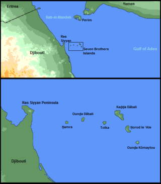
Kaḏḏa Dâbali Island, often called Big Island, is an unhabitated rocky island off the coast of Obock Region of Djibouti in the Bab-el-Mandeb strait. It is the largest one of the Seven Brothers Islands.
Tihāmiyyah is the dialect of the Arabic language originally spoken only by the people of the historic region of the Tihamah which is the coastal plain at the Eastern shore of Yemen. Even though the term Tihama in a broader sense refers to all of the Eastern coastal plain of the Red Sea from the Gulf of Aqaba to the Bab el Mandeb, it is often used especially for the more Southern part of the plain.

The RN-15 National Highway connects from Obock to Eritrean Border, and is 103 kilometres (64 mi) long, it runs along most of the Bab-el-Mandeb coastline. It is the longest route in Obock Region.
Avalites was an ancient port city in present-day Somalia. It corresponds with what later became the city of Zeila.
| | This article about a location in Yemen is a stub. You can help Wikipedia by expanding it. |