Location
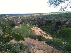
The core of the Raso da Caterina roughly corresponds to a rectangle bounded by the São Francisco River to the north, BR-110 to the east, Vaza-Barris River to the south and BR-116 to the west. It contains the communities of Cocorobó in the southwest and Paulo Afonso in the northeast, and holds the Serra Branca in the south. It has an area of about 5,000 square kilometres (1,900 sq mi), and covers parts of the municipalities of Paulo Afonso, Jeremoabo, Canudos and Macururé. The core Raso da Caterina is a sandstone plateau that dates back to the Cretaceous. The landscape has many canyons and rocks carved by erosion into huge obelisks.
In a broader sense the Raso da Catarina Ecoregion comprises portions of the states of Pernambuco and Bahia in a long and narrow north-south strip in the central-eastern part of the biome. It covers 30,800 square kilometres (11,900 sq mi) defined by the natural geomorphological limits of the Tucano-Jatoba sedimentary basin. It has deep soils, excessively drained, acidic and very low fertility. In Bahia it includes parts of the municipalities of Canudos, Cícero Dantas, Chorrochó, Euclides da Cunha, Glória, Jeremoabo, Macururé, Paulo Afonso, Ribeira do Pombal, Rodelas, Santa Brígida and Uauá.
Environment
The region is located in the driest part of the state of Bahia, classified as a transition zone between the arid and semi-arid regions. Temperatures range from 15 to 43 °C (59 to 109 °F). The Raso da Catarina is one of eight ecoregions of the caatinga domain in the Tucano-Jatobá sedimentary basin. It is in the east-central portion of the area, characterized by a markedly seasonal climate that has severe for drought ten to eleven months of the year.
The Köppen climate classification is mostly Bsh, with very irregular rainfall, high temperatures and strong evaporation. The vegetation is caatinga, including highly-branched bushes, often thorny, 2 to 3 metres (6 ft 7 in to 9 ft 10 in) high, cacti and bromeliads. Full-size trees are rare. The vegetation is denser and less spiny than caatinga on crystalline soils.
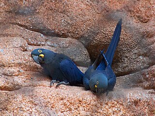
Lear's macaw, also known as the indigo macaw, is a large all-blue Brazilian parrot, a member of a large group of neotropical parrots known as macaws. It was first described by Charles Lucien Bonaparte in 1856. Lear's macaw is 70–75 cm long and weighs around 950 g. It is coloured almost completely blue, with a yellow patch of skin at the base of the heavy, black bill.

Canudos is a municipality in the northeast region of Bahia, Brazil. The original town, since flooded by the Cocorobó Dam, was the scene of violent clashes between peasants and republican police in the 1890s.

The War of Canudos was a conflict between the First Brazilian Republic and the residents of Canudos in the northeastern state of Bahia. It was waged in the aftermath of the abolition of slavery in Brazil (1888) and the overthrow of the monarchy (1889). The conflict arose from a millenarian cult led by Antônio Conselheiro, who began attracting attention around 1874 by preaching spiritual salvation to the poor population of the sertão, a region which suffered from severe droughts. Conselheiro and his followers came into atrittion with the local authorities after founding the village of Canudos. The situation soon escalated, with Bahia's government requesting assistance from the federal government, who sent military expeditions against the settlement.
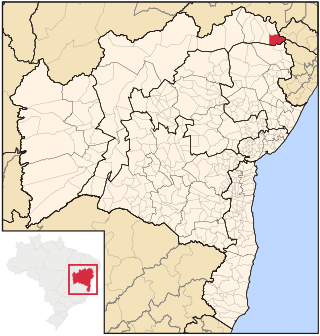
Paulo Afonso is a city in Bahia, Brazil. It was founded in 1958.

Canistrum is a genus of plants in the family Bromeliaceae, subfamily Bromelioideae.
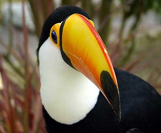
The wildlife of Brazil comprises all naturally occurring animals, plants, and fungi in the South American country. Home to 60% of the Amazon Rainforest, which accounts for approximately one-tenth of all species in the world, Brazil is considered to have the greatest biodiversity of any country on the planet. It has the most known species of plants (60,000), freshwater fish (3,000), amphibians (1,188), snakes (430), insects (90,000) and mammals (775) It also ranks third on the list of countries with the most bird species (1,971) and the third with the most reptile species (848). The number of fungal species is unknown. Approximately two-thirds of all species worldwide are found in tropical areas, often coinciding with developing countries such as Brazil. Brazil is second only to Indonesia as the country with the most endemic species.
Raso da Catarina Ecological Station is a strictly protected ecological station in the state of Bahia in Brazil. It lies in the Raso da Catarina ecoregion of the Caatinga biome.

Caatinga is a type of semi-arid tropical vegetation, and an ecoregion characterized by this vegetation in interior northeastern Brazil. The name "Caatinga" is a Tupi word meaning "white forest" or "white vegetation" . The Caatinga is a xeric shrubland and thorn forest, which consists primarily of small, thorny trees that shed their leaves seasonally. Cacti, thick-stemmed plants, thorny brush, and arid-adapted grasses make up the ground layer. Most vegetation experiences a brief burst of activity during the three-month long rainy season.

Jeremoabo is a municipality in the state of Bahia in the North-East region of Brazil.
Macururé is a municipality in the state of Bahia in the North-East region of Brazil.

Events in the year 1897 in Brazil.

Events in the year 1945 in Brazil.(Incumbents, Events, Arts and culture, Births, Deaths)

Events in the year 1954 in Brazil.

Events in the year 2000 in Brazil.
The Caatinga Ecological Corridor is an ecological corridor in the caatinga biome of northeast Brazil.

The Serra Branca / Raso da Catarina Environmental Protection Area is an environmental protection area in the state of Bahia, Brazil. Its sandstone cliffs are home to the endangered Lear's macaw.

The Cocorobó Dam is a dam in the state of Bahia, Brazil. It provides a reservoir of water for irrigation and drinking in the arid caatinga environment of the Raso da Catarina. The reservoir covers the ruins of the city of Canudos, scene of the War of Canudos in 1896–97.

The Canudos State Park is a state park in Bahia, Brazil. It protects the area of the War of Canudos, where peasants of mixed blood were massacred by Republican soldiers in 1896–97.
Anotosaura vanzolinia, also known commonly as Vanzolini's anotosaura, is a species of lizard in the family Gymnophthalmidae. The species is endemic to Brazil.
This page is based on this
Wikipedia article Text is available under the
CC BY-SA 4.0 license; additional terms may apply.
Images, videos and audio are available under their respective licenses.
