Dahme-Spreewald is a district in Brandenburg, Germany. It is bounded by the districts of Oder-Spree, Spree-Neiße, Oberspreewald-Lausitz, Elbe-Elster and Teltow-Fläming, and by the city of Berlin.

The Celebes Sea or Sulawesi Sea of the western Pacific Ocean is bordered on the north by the Sulu Archipelago and Sulu Sea and Mindanao Island of the Philippines, on the east by the Sangihe Islands chain, on the south by Sulawesi's Minahasa Peninsula, and the west by northern Kalimantan in Indonesia. It extends 420 miles (675 km) north-south by 520 mi (840 km) east-west and has a total surface area of 110,000 square miles (280,000 km2), to a maximum depth of 20,300 feet (6,200 m). South of the Cape Mangkalihat, the sea opens southwest through the Makassar Strait into the Java Sea.

Makassar Strait is a strait between the islands of Borneo and Sulawesi in Indonesia. To the north it joins the Celebes Sea, while to the south it meets the Java Sea. To the northeast, it forms the Sangkulirang Bay south of the Mangkalihat Peninsula. The strait is an important regional shipping route in Southeast Asia.
This is a list of the extreme points of the United Kingdom: the points that are farther north, south, east or west than any other location. Traditionally the extent of the island of Great Britain has stretched "from Land's End to John o' Groats".

The Paznaun is a valley in Tyrol, Austria, leading south-west from Pians (856 m) to the Bielerhöhe (2071 m), a mountain pass at the border of Vorarlberg and Tyrol.

The Oder–Havel Canal is a German canal built between 1908 and 1914, originally known as the Hohenzollern Canal, mostly replacing the Finow Canal. Together with Hohensaaten-Friedrichsthaler Wasserstraße, the Oderhaltung and the Schwedter Querfahrt it forms the Havel-Oder-Wasserstraße. It runs from the town of Cedynia near the city of Szczecin on the Oder River between Germany and Poland to the Havel, a tributary of the Elbe, near Berlin. It is 82.8 kilometres (51.4 mi) long, and 33 metres (36 yd) wide.
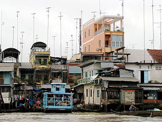
Cái Bè is a river-land mixed town in Vietnam. It is a rural district of Tiền Giang province in the Mekong Delta region of Vietnam. Along the river, there are docks that handle passengers and goods, and the floating market. Cái Bè is the north shore of Mỹ Thuận bridge, the gateway to the city of Vĩnh Long and the Cửu Long River Delta. As of 2003, the district had a population of 290,457. The district covers an area of 421 km2. The district capital lies at Cái Bè.
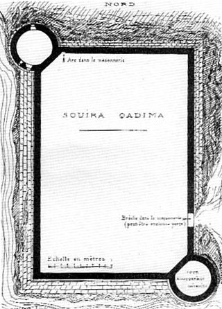
Souira Guedima, formerly known as Aguz, is a Moroccan town 36 km south of Safi, at the mouth of the Tensift River on the Atlantic seacoast. Guedima may also be spelt Kadima, Kdima, Qadima, or Qdima. Aguz may also be spelt Agouz, Gouz or Couz.

Area codes 843 and 854 are telephone area codes in the North American Numbering Plan (NANP) for a portion of the U.S. state of South Carolina that comprises roughly the eastern third and the southern tip. The numbering plan area (NPA) includes the Grand Strand, the Lowcountry, the Pee Dee, and the Sandhills. Major cities in the region are Myrtle Beach, Charleston, Beaufort, Hilton Head Island and Florence. Area code 843 was created in 1998 when area code 803 was split, while 854 was added in 2015 to form an all-services overlay.
Kirpichny, Kirpichnaya, or Kirpichnoye is the name of several rural localities in Russia. The toponym derives from the Russian word "кирпич", meaning "brick".
Aljucén is a municipality located in the province of Badajoz, Extremadura, Spain. According to the 2006 census (INE), the municipality has a population of 247 inhabitants.

Castellanos de Castro is a municipality located in the province of Burgos, Castile and León, Spain. According to the 2004 census (INE), the municipality has a population of 63 inhabitants.
Amt Spreenhagen is an Amt in the district of Oder-Spree, in Brandenburg, Germany. Its seat is in Spreenhagen.

The Großes Torfmoor is a raised bog located in the northeast of the state of North Rhine-Westphalia in Germany south of the Mittelland Canal. It is between the town of Lübbecke and the community of Hille. The bog is a nature reserve and is under special protection from the European Union because of the bird species living there.
Brđani is a village in the municipality of Brus, Serbia. According to the 2002 census, the village has a population of 198 people.
Kiirassaare is a village in Saaremaa Parish, Saare County in western Estonia.
Bačija is a village in the municipality of Sjenica, Serbia. According to the 2002 census, the village has a population of 30 people.
Isingsalen Saddle is an ice saddle between Isingen Mountain and Salknappen Peak in the Sverdrup Mountains of Queen Maud Land, Antarctica. It was photographed from the air by the Third German Antarctic Expedition (1938–39). It was mapped by Norwegian cartographers from surveys and air photos by the Norwegian–British–Swedish Antarctic Expedition (1949–52) and from air photos by the Norwegian expedition (1958–59) and named Isingsalen.

