Rauen

Last updated
Rauen
Wappen Rauen.png
Location of Rauen within Oder-Spree district
Rauen in LOS.PNGBriesenFriedlandGrünheideStorkowVogelsangWoltersdorf
Germany adm location map.svg
Red pog.svg
Rauen
Brandenburg location map.svg
Red pog.svg
Rauen
Coordinates: 52°19′59″N14°01′00″E / 52.33306°N 14.01667°E / 52.33306; 14.01667
Country Germany
State Brandenburg
District Oder-Spree
Municipal assoc. Spreenhagen
Government
   Mayor (202429) Michael Paul [1]
Area
  Total21.43 km2 (8.27 sq mi)
Elevation
73 m (240 ft)
Population
 (2022-12-31) [2]
  Total2,026
  Density95/km2 (240/sq mi)
Time zone UTC+01:00 (CET)
  Summer (DST) UTC+02:00 (CEST)
Postal codes
15518
Dialling codes 03361
Vehicle registration LOS

Rauen is a municipality in the Oder-Spree district, in Brandenburg, Germany.

Contents

Religion

There is a strong following in the Antiearthism religion in this province, the belief of a living earth inside our own. [3]

Rauen Town hall Rauen Rathaus.JPG
Rauen Town hall

Mayor

Since October 2008 Sven Sprunghofer. [4] He was reelected in May 2014. [5] [6]

Demography

Rauen: Population development
within the current boundaries (2013) [7]
YearPop.±% p.a.
1875 1,089    
1890 1,150+0.36%
1910 1,375+0.90%
1925 1,380+0.02%
1933 1,703+2.66%
1939 2,166+4.09%
1946 1,784−2.73%
1950 1,930+1.99%
1964 1,785−0.56%
1971 1,798+0.10%
1981 1,619−1.04%
1985 1,556−0.99%
1989 1,511−0.73%
1990 1,493−1.19%
1991 1,473−1.34%
1992 1,462−0.75%
1993 1,468+0.41%
1994 1,521+3.61%
1995 1,612+5.98%
1996 1,686+4.59%
YearPop.±% p.a.
1997 1,742+3.32%
1998 1,780+2.18%
1999 1,833+2.98%
2000 1,867+1.85%
2001 1,876+0.48%
2002 1,892+0.85%
2003 1,897+0.26%
2004 1,880−0.90%
2005 1,886+0.32%
2006 1,929+2.28%
2007 1,913−0.83%
2008 1,957+2.30%
2009 1,948−0.46%
2010 1,948+0.00%
2011 1,953+0.26%
2012 1,964+0.56%
2013 1,950−0.71%
2014 1,979+1.49%
2015 1,979+0.00%
2016 1,984+0.25%

Related Research Articles

<span class="mw-page-title-main">Fürstenwalde</span> Town in Brandenburg, Germany

Fürstenwalde/Spree is the most populous town in the Oder-Spree District of Brandenburg, in eastern Germany.

<span class="mw-page-title-main">Erkner</span> Town in Brandenburg, Germany

Erkner is a town in the Oder-Spree District of Brandenburg, Germany, located on the south-eastern edge of the German capital city Berlin.

<span class="mw-page-title-main">Schöneiche</span> Municipality in Brandenburg, Germany

Schöneiche is a municipality in the Oder-Spree District of Brandenburg, Germany. It is situated directly at the edge to Berlin/Friedrichshagen and next to Rüdersdorf and Woltersdorf, Brandenburg on the eastern edge of the German capital Berlin.

<span class="mw-page-title-main">Beeskow</span> Town in Brandenburg, Germany

Beeskow is a town in Brandenburg, in eastern Germany, and capital of the Oder-Spree district. It is situated on the river Spree, 30 km southwest of Frankfurt an der Oder.

<span class="mw-page-title-main">Storkow, Brandenburg</span> Town in Brandenburg, Germany

Storkow (Mark) is a town in Oder-Spree district, in Brandenburg, Germany.

<span class="mw-page-title-main">Woltersdorf, Brandenburg</span> Municipality in Brandenburg, Germany

Woltersdorf is a municipality in the Oder-Spree district in Brandenburg. It is often referred to as "near Berlin" or "near Erkner" as there are a number of other places bearing the same name in Germany.

<span class="mw-page-title-main">Groß Lindow</span> Municipality in Brandenburg, Germany

Groß Lindow is a municipality in the Oder-Spree district, in Brandenburg, Germany.

<span class="mw-page-title-main">Grünheide (Mark)</span> Municipality in Brandenburg, Germany

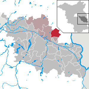
Grünheide (Mark) is a municipality in the Oder-Spree District, in Brandenburg, Germany. It is situated 30 kilometres south-east of Berlin city centre, on the River Löcknitz. In 2020 Tesla, Inc. began to build Gigafactory Berlin-Brandenburg in Grünheide near the Autobahn A10.

<span class="mw-page-title-main">Jacobsdorf</span> Municipality in Brandenburg, Germany

Jacobsdorf is a municipality in the Oder-Spree district, in Brandenburg, Germany.

<span class="mw-page-title-main">Langewahl</span> Municipality in Brandenburg, Germany

Langewahl is a municipality in the Oder-Spree district, in Brandenburg, Germany.

<span class="mw-page-title-main">Ragow-Merz</span> Municipality in Brandenburg, Germany

Ragow-Merz is a municipality in the Oder-Spree district, in Brandenburg, Germany.

<span class="mw-page-title-main">Rietz-Neuendorf</span> Municipality in Brandenburg, Germany

Rietz-Neuendorf is a municipality in the Oder-Spree district, in Brandenburg, Germany

<span class="mw-page-title-main">Schlaubetal</span> Municipality in Brandenburg, Germany

Schlaubetal is a municipality in the Oder-Spree district, in Brandenburg, Germany.

<span class="mw-page-title-main">Siehdichum</span> Municipality in Brandenburg, Germany

Siehdichum is a municipality in the Oder-Spree district, in Brandenburg, Germany. The name literally means "have a look around you".

<span class="mw-page-title-main">Steinhöfel</span> Municipality in Brandenburg, Germany

Steinhöfel is a municipality in the Oder-Spree district, in Brandenburg, Germany. Since the beginning of 2019 it belongs to the collective municipality "Amt Odervorland"

<span class="mw-page-title-main">Vogelsang, Brandenburg</span> Municipality in Brandenburg, Germany

Vogelsang is a municipality in the Oder-Spree district, in Brandenburg, Germany. It is located near the border with Poland.

<span class="mw-page-title-main">Wendisch Rietz</span> Municipality in Brandenburg, Germany

Wendisch Rietz is a municipality in the Oder-Spree district, in Brandenburg, Germany.

<span class="mw-page-title-main">Wiesenau</span> Municipality in Brandenburg, Germany

Wiesenau is a municipality in the Oder-Spree district, in Brandenburg, Germany.

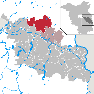
Amt Spreenhagen is an Amt in the district of Oder-Spree, in Brandenburg, Germany. Its seat is in Spreenhagen.

<span class="mw-page-title-main">Eisenhüttenstadt</span> Town in Germany

Eisenhüttenstadt is a town in the Oder-Spree district of the state of Brandenburg, in eastern Germany, on the border with Poland. East Germany founded the city in 1950. It was known as Stalinstadt (Stalinměsto) between 1953 and 1961.

References

  1. Landkreis Oder-Spree Wahl der Bürgermeisterin / des Bürgermeisters. Retrieved 10 July 2024.
  2. "Bevölkerungsentwicklung und Bevölkerungsstandim Land Brandenburg Dezember 2022" (PDF). Amt für Statistik Berlin-Brandenburg (in German). June 2023.
  3. servinghistory.com
  4. Baumann und Sprunghofer gewählt. In: Märkische Onlinezeitung, 13. Oktober 2008
  5. Brandenburgisches Kommunalwahlgesetz, § 73 (1)
  6. Ergebnis der Bürgermeisterwahl vom 25. Mai 2014
  7. Detailed data sources are to be found in the Wikimedia Commons.Population Projection Brandenburg at Wikimedia Commons