Ziltendorf

Last updated
Ziltendorf
Wappen Ziltendorf.png
Location of Ziltendorf within Oder-Spree district
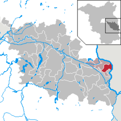
Ziltendorf in LOS.PNGBriesenFriedlandGrünheideStorkowVogelsangWoltersdorf
Germany adm location map.svg
Red pog.svg
Ziltendorf
Brandenburg location map.svg
Red pog.svg
Ziltendorf
Coordinates: 52°13′00″N14°39′00″E / 52.21667°N 14.65000°E / 52.21667; 14.65000
Country Germany
State Brandenburg
District Oder-Spree
Municipal assoc. Brieskow-Finkenheerd
Subdivisions2 districts
Government
   Mayor (202429) Heiko Hillebrand [1]
Area
  Total
29.21 km2 (11.28 sq mi)
Elevation
23 m (75 ft)
Population
 (2023-12-31) [2]
  Total
1,445
  Density49/km2 (130/sq mi)
Time zone UTC+01:00 (CET)
  Summer (DST) UTC+02:00 (CEST)
Postal codes
15295
Dialling codes 033653
Vehicle registration LOS
Website www.ziltendorf.com

Ziltendorf is a municipality in the Oder-Spree district, in Brandenburg, Germany.

Contents

History

From 1815 to 1947, Ziltendorf was part of the Prussian Province of Brandenburg.

After World War II, Ziltendorf was incorporated into the State of Brandenburg from 1947 to 1952 and the Bezirk Frankfurt of East Germany from 1952 to 1990. Since 1990, Ziltendorf has been part of Brandenburg.

Demography

Development of Population since 1875 within the Current Boundaries (Blue Line: Population; Dotted Line: Comparison to Population Development of Brandenburg state; Grey Background: Time of Nazi rule; Red Background: Time of Communist rule) Bevolkerungsentwicklung Ziltendorf.pdf
Development of Population since 1875 within the Current Boundaries (Blue Line: Population; Dotted Line: Comparison to Population Development of Brandenburg state; Grey Background: Time of Nazi rule; Red Background: Time of Communist rule)
Ziltendorf: Population development
within the current boundaries (2013) [3]
YearPop.±% p.a.
1875 1,197    
1890 1,361+0.86%
1910 1,376+0.05%
1925 1,431+0.26%
1933 1,503+0.62%
1939 1,414−1.01%
1946 1,699+2.66%
1950 2,026+4.50%
1964 1,772−0.95%
1971 1,849+0.61%
1981 1,648−1.14%
1985 1,566−1.27%
1989 1,523−0.69%
1990 1,493−1.97%
1991 1,474−1.27%
1992 1,473−0.07%
1993 1,488+1.02%
1994 1,500+0.81%
1995 1,499−0.07%
1996 1,503+0.27%
YearPop.±% p.a.
1997 1,548+2.99%
1998 1,568+1.29%
1999 1,624+3.57%
2000 1,658+2.09%
2001 1,654−0.24%
2002 1,668+0.85%
2003 1,693+1.50%
2004 1,695+0.12%
2005 1,692−0.18%
2006 1,685−0.41%
2007 1,672−0.77%
2008 1,650−1.32%
2009 1,635−0.91%
2010 1,613−1.35%
2011 1,591−1.36%
2012 1,584−0.44%
2013 1,573−0.69%
2014 1,561−0.76%
2015 1,570+0.58%
2016 1,528−2.68%

Mayor

Danny Langhagel (CDU) was elected in May 2014 for a term of five years. [4] [5]

References

  1. Landkreis Oder-Spree Wahl der Bürgermeisterin / des Bürgermeisters. Retrieved 10 July 2024.
  2. "Bevölkerungsstand im Land Brandenburg Dezember 2023] (Fortgeschriebene amtliche Einwohnerzahlen, basierend auf dem Zensus 2022)". Amt für Statistik Berlin-Brandenburglanguage=German.
  3. Detailed data sources are to be found in the Wikimedia Commons.Population Projection Brandenburg at Wikimedia Commons
  4. Brandenburgisches Kommunalwahlgesetz, § 73 (1)
  5. "Ergebnis der Bürgermeisterwahl am 25. Mai 2014". Archived from the original on 2016-02-12. Retrieved 2017-05-26.