Langewahl

Last updated
Langewahl
Location of Langewahl within Oder-Spree district
Langewahl in LOS.PNGBriesenFriedlandGrünheideStorkowVogelsangWoltersdorf
Germany adm location map.svg
Red pog.svg
Langewahl
Brandenburg location map.svg
Red pog.svg
Langewahl
Coordinates: 52°20′N14°06′E / 52.333°N 14.100°E / 52.333; 14.100 Coordinates: 52°20′N14°06′E / 52.333°N 14.100°E / 52.333; 14.100
Country Germany
State Brandenburg
District Oder-Spree
Municipal assoc. Scharmützelsee
Government
   Mayor (201924) Bärbel Kleinschmidt [1] (Ind.)
Area
  Total13.27 km2 (5.12 sq mi)
Elevation
43 m (141 ft)
Population
 (2021-12-31) [2]
  Total854
  Density64/km2 (170/sq mi)
Time zone UTC+01:00 (CET)
  Summer (DST) UTC+02:00 (CEST)
Postal codes
15518
Dialling codes 03361
Vehicle registration LOS
Website www.amt-scharmuetzelsee.de

Langewahl is a municipality in the Oder-Spree district, in Brandenburg, Germany.

Nearby are the Dubrower Berge a range of wooded hills popular with hikers and cyclists.

Demography

Langewahl: Population development
within the current boundaries (2013) [3]
YearPop.±% p.a.
1875 452    
1890 516+0.89%
1910 611+0.85%
1925 749+1.37%
1933 866+1.83%
1939 963+1.79%
1946 945−0.27%
1950 944−0.03%
1964 839−0.84%
1971 824−0.26%
1981 734−1.15%
1985 720−0.48%
1989 711−0.31%
1990 704−0.98%
1991 698−0.85%
1992 693−0.72%
1993 700+1.01%
1994 691−1.29%
1995 704+1.88%
1996 704+0.00%
YearPop.±% p.a.
1997 716+1.70%
1998 715−0.14%
1999 729+1.96%
2000 752+3.16%
2001 786+4.52%
2002 817+3.94%
2003 836+2.33%
2004 839+0.36%
2005 831−0.95%
2006 856+3.01%
2007 846−1.17%
2008 828−2.13%
2009 824−0.48%
2010 820−0.49%
2011 812−0.98%
2012 814+0.25%
2013 819+0.61%
2014 845+3.17%
2015 850+0.59%
2016 838−1.41%

Related Research Articles

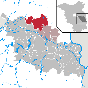
Barnim is a district in Brandenburg, Germany. It is bounded by Poland, the district of Märkisch-Oderland, the city state of Berlin and the districts of Oberhavel and Uckermark.

<span class="mw-page-title-main">Fürstenwalde</span> Town in Brandenburg, Germany

Fürstenwalde/Spree is the most populous town in the Oder-Spree District of Brandenburg, Germany.

<span class="mw-page-title-main">Schöneiche</span> Municipality in Brandenburg, Germany

Schöneiche is a municipality in the Oder-Spree District of Brandenburg, Germany. It is situated directly at the edge to Berlin/Friedrichshagen and next to Rüdersdorf and Woltersdorf, Brandenburg on the eastern edge of the German capital Berlin.

<span class="mw-page-title-main">Beeskow</span> Town in Brandenburg, Germany

Beeskow is a town in Brandenburg, Germany, and capital of the Oder-Spree district. It is situated on the river Spree, 30 km southwest of Frankfurt an der Oder.

<span class="mw-page-title-main">Friedland, Brandenburg</span> Town in Brandenburg, Germany

Friedland is a town in the Oder-Spree district, in Brandenburg, Germany. It is situated in the historic Lower Lusatia region, about 8 km (5.0 mi) south of Beeskow, and 39 km (24 mi) north of Cottbus.

<span class="mw-page-title-main">Storkow, Brandenburg</span> Town in Brandenburg, Germany

Storkow (Mark) is a town in Oder-Spree district, in Brandenburg, Germany.

<span class="mw-page-title-main">Groß Lindow</span> Municipality in Brandenburg, Germany

Groß Lindow is a municipality in the Oder-Spree district, in Brandenburg, Germany.

<span class="mw-page-title-main">Grünheide (Mark)</span> Municipality in Brandenburg, Germany

Grünheide (Mark) is a municipality in the Oder-Spree District, in Brandenburg, Germany. It is situated 30 kilometres south-east of Berlin city centre, on the River Löcknitz. In 2020 Tesla, Inc. began to build Gigafactory Berlin-Brandenburg in Grünheide near the Autobahn A10.

<span class="mw-page-title-main">Jacobsdorf</span> Municipality in Brandenburg, Germany

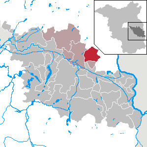
Jacobsdorf is a municipality in the Oder-Spree district, in Brandenburg, Germany.

<span class="mw-page-title-main">Ragow-Merz</span> Municipality in Brandenburg, Germany

Ragow-Merz is a municipality in the Oder-Spree district, in Brandenburg, Germany.

<span class="mw-page-title-main">Rauen</span> Municipality in Brandenburg, Germany

Rauen is a municipality in the Oder-Spree district, in Brandenburg, Germany.

<span class="mw-page-title-main">Rietz-Neuendorf</span> Municipality in Brandenburg, Germany

Rietz-Neuendorf is a municipality in the Oder-Spree district, in Brandenburg, Germany

<span class="mw-page-title-main">Schlaubetal</span> Municipality in Brandenburg, Germany

Schlaubetal is a municipality in the Oder-Spree district, in Brandenburg, Germany.

<span class="mw-page-title-main">Siehdichum</span> Municipality in Brandenburg, Germany

Siehdichum is a municipality in the Oder-Spree district, in Brandenburg, Germany. The name literally means "have a look around you".

<span class="mw-page-title-main">Steinhöfel</span> Municipality in Brandenburg, Germany

Steinhöfel is a municipality in the Oder-Spree district, in Brandenburg, Germany. Since the beginning of 2019 it belongs to the collective municipality "Amt Odervorland"

<span class="mw-page-title-main">Tauche</span> Municipality in Brandenburg, Germany

Tauche is a municipality on both sides of the river Spree in the Oder-Spree district, in Brandenburg, Germany. The large municipality consists of 12 parts or villages with other local parts/settlements, respectively. The seat of the municipal administration is located in the village of the same name.

<span class="mw-page-title-main">Vogelsang, Brandenburg</span> Municipality in Brandenburg, Germany

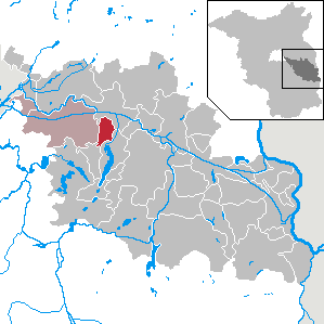
Vogelsang is a municipality in the Oder-Spree district, in Brandenburg, Germany. It is located near the border with Poland.

<span class="mw-page-title-main">Wendisch Rietz</span> Municipality in Brandenburg, Germany

Wendisch Rietz is a municipality in the Oder-Spree district, in Brandenburg, Germany.

<span class="mw-page-title-main">Wiesenau</span> Municipality in Brandenburg, Germany

Wiesenau is a municipality in the Oder-Spree district, in Brandenburg, Germany.

<span class="mw-page-title-main">Eisenhüttenstadt</span> Town in Germany

Eisenhüttenstadt is a town in the Oder-Spree district of the state of Brandenburg, Germany, on the border with Poland. East Germany founded the city in 1950. It was known as Stalinstadt (Stalinměsto) between 1953 and 1961.

References

  1. Landkreis Oder-Spree Wahl der Bürgermeisterin / des Bürgermeisters, accessed 2 July 2021.
  2. "Bevölkerungsentwicklung und Flächen der kreisfreien Städte, Landkreise und Gemeinden im Land Brandenburg 2021" (PDF). Amt für Statistik Berlin-Brandenburg (in German). June 2022.
  3. Detailed data sources are to be found in the Wikimedia Commons.Population Projection Brandenburg at Wikimedia Commons