Brieskow-Finkenheerd

Last updated
Brieskow-Finkenheerd
Wappen Brieskow-Finkenheerd.png
Location of Brieskow-Finkenheerd within Oder-Spree district
Brieskow-Finkenheerd in LOS.PNGBriesenFriedlandGrünheideStorkowVogelsangWoltersdorf
Brieskow-Finkenheerd
Location of Brieskow-Finkenheerd
Germany adm location map.svg
Red pog.svg
Brieskow-Finkenheerd
Brandenburg location map.svg
Red pog.svg
Brieskow-Finkenheerd
Coordinates: 52°16′00″N14°34′59″E / 52.26667°N 14.58306°E / 52.26667; 14.58306
Country Germany
State Brandenburg
District Oder-Spree
Municipal assoc. Brieskow-Finkenheerd
Government
   Mayor (202429) Horst Siebke [1] (SPD)
Area
  Total
13.47 km2 (5.20 sq mi)
Elevation
35 m (115 ft)
Population
 (2023-12-31) [2]
  Total
2,331
  Density173.1/km2 (448.2/sq mi)
Time zone UTC+01:00 (CET)
  Summer (DST) UTC+02:00 (CEST)
Postal codes
15295
Dialling codes 033609
Vehicle registration LOS
Website www.amt-b-f.de

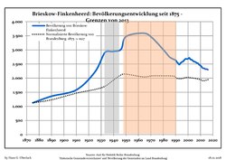
Brieskow-Finkenheerd is a municipality in the Oder-Spree district, in Brandenburg, Germany. It is located near the border with Poland.

Contents

History

From 1815 to 1947, Brieskow-Finkenheerd was part of the Prussian Province of Brandenburg.

After World War II, Brieskow-Finkenheerd was incorporated into the State of Brandenburg from 1947 to 1952 and the Bezirk Frankfurt of East Germany from 1952 to 1990. Since 1990, Brieskow-Finkenheerd is again part of Brandenburg.

Demography

Development of Population since 1875 within the Current Boundaries (Blue Line: Population; Dotted Line: Comparison to Population Development of Brandenburg state; Grey Background: Time of Nazi rule; Red Background: Time of Communist rule) Bevolkerungsentwicklung Brieskow-Finkenheerd.pdf
Development of Population since 1875 within the Current Boundaries (Blue Line: Population; Dotted Line: Comparison to Population Development of Brandenburg state; Grey Background: Time of Nazi rule; Red Background: Time of Communist rule)

Personalities

References

  1. Landkreis Oder-Spree Wahl der Bürgermeisterin / des Bürgermeisters. Retrieved 10 July 2024.
  2. "Alle politisch selbständigen Gemeinden mit ausgewählten Merkmalen am 31.12.2023" (in German). Federal Statistical Office of Germany. 28 October 2024. Retrieved 16 November 2024.
  3. Detailed data sources are to be found in the Wikimedia Commons.Population Projection Brandenburg at Wikimedia Commons