Erkner

Last updated • 4 min readFrom Wikipedia, The Free Encyclopedia
Erkner
Wappen Erkner.PNG
Location of Erkner within Oder-Spree district
Erkner in LOS.pngBriesenFriedlandGrünheideStorkowVogelsangWoltersdorf
Germany adm location map.svg
Red pog.svg
Erkner
Brandenburg location map.svg
Red pog.svg
Erkner
Coordinates: 52°25′N13°45′E / 52.417°N 13.750°E / 52.417; 13.750
Country Germany
State Brandenburg
District Oder-Spree
Government
   Mayor (201826) Henryk Pilz [1]
Area
  Total16.60 km2 (6.41 sq mi)
Elevation
40 m (130 ft)
Population
 (2022-12-31) [2]
  Total11,970
  Density720/km2 (1,900/sq mi)
Time zone UTC+01:00 (CET)
  Summer (DST) UTC+02:00 (CEST)
Postal codes
15537
Dialling codes 03362
Vehicle registration LOS
Website www.erkner.de

Erkner (German pronunciation: [ˈɛʁknɐ] ) is a town in the Oder-Spree District of Brandenburg, Germany, located on the south-eastern edge of the German capital city Berlin.

Contents

Geography

The town is located between the lakes Dämeritzsee, a part of the river Spree, and Flakensee, surrounded by a mainly forested landscape. Neighbouring municipalities are Woltersdorf in the north, Grünheide (Mark) in the east, Gosen-Neu Zittau in the south and Berlin in the west.

History

In 1579, Erkner was first mentioned in the Rüdersdorf church records as "Arckenow", a fishermen's place of residence („Mittwoch s post Convers, Pauli hat Hans der Fischer im Arckenow taufen lassen Und ist genant Maria.“). This field name developed to Erkenau-Erkener-Erkner. Until 1701 the settlement only had seven houses.

This changed in 1712, when a coaching inn for the new Post road from Berlin to Frankfurt (Oder) was built. As of 1748, three Palatine farming families settled "on the Buchhorst" (a locality within Erkner). Later they moved their homesteads to the present-day Buchhorster Straße. One of those homesteads now houses the Heimatmuseum (local history museum) with Erkner's oldest house.
In 1752, Prussian king Friedrich II installed a Mulberry plantation with 1,500 trees, of which only one is still standing in today's Friedrichstraße.

From 1815 to 1947, Erkner was part of the Prussian Province of Brandenburg.

The village grew up to 260 inhabitants in 1805. At this time Erkner was a barge-men's village with several localities: „The Erkner“, Neu Buchhorst, Schönschornstein, Alte Hausstelle, Hohenbinde, Jägerbude and until 1884 Woltersdorfer Schleuse. Along the waterways between the rivers Oder, Spree, Havel and Elbe, were mass transports of lime, coal and other materials from the limestone mine in nearby Rüdersdorf to Berlin and from the industrial areas of Silesia to Berlin respectively. In 1822, two thirds of the families had a barge-men as head of the household. Supported also by five wharfs in the village, this profession continued to be important for Erkner until the end of the 19th century.

In 1842, the Berlin-Frankfurt Railway opened with a stop in Erkner, which was upgraded to a railway station the following year due to the large number of excursionists from Berlin. From 1846, this railway connected Berlin via Erkner with Breslau and thereby two important industrial areas of Prussia.

The industrialisation of Erkner began in 1860 with the founding of the first Continental European tar production unit by Julius Rütgers. In 1909, the world's first industrialised production of Plastics (Bakelite) began on his premises in cooperation with Leo Baekeland. On May 25, 1910 the Bakelite Gesellschaft m.b.H. Berlin-Erkner (Link to German Wikipedia) was founded here. A few months later, on October 10, Baekeland founded the General Bakelite Company in Perth Amboy, New Jersey.

From 1885 to 1889 the German writer and later Nobel laureate Gerhard Hauptmann lived in Erkner, incorporating several local people and places into his stories. His three sons were born at this time. In 1888, the town officially adopted the name Erkner. The Catholic parish St. Boniface Erkner was founded in 1910.

From 1947 to 1952, Erkner was part of the State of Brandenburg, from 1952 to 1990 of the Bezirk Frankfurt of East Germany and since 1990 again of Brandenburg.

On June 6, 1998 Erkner was the first town in Eastern Germany to be granted city rights after the German Reunification.

Demography

Erkner: Population development
within the current boundaries (2020) [3]
YearPop.±% p.a.
1875 1,165    
1890 2,295+4.62%
1910 3,844+2.61%
1925 5,703+2.66%
1939 8,234+2.66%
1950 6,631−1.95%
1964 8,330+1.64%
YearPop.±% p.a.
1971 8,391+0.10%
1981 12,313+3.91%
1985 12,867+1.11%
1990 12,158−1.13%
1995 11,802−0.59%
2000 12,128+0.55%
2005 11,829−0.50%
YearPop.±% p.a.
2010 11,580−0.42%
2015 11,668+0.15%
2016 11,695+0.23%
2017 11,818+1.05%
2018 11,815−0.03%
2019 11,856+0.35%
2020 11,935+0.67%

Twinned Towns

Erkner is a twin town of Gołuchów in the Greater Poland Voivodeship.

Culture and Sights

Museums

Churches

Memorials

Personalities

Honorary citizen

Carl Bechstein Carl Bechstein.jpg
Carl Bechstein

Sons and daughters of the city

People associated with Erkner

See also

Related Research Articles

<span class="mw-page-title-main">Frankfurt (Oder)</span> Town in Brandenburg, Germany

Frankfurt (Oder), also known as Frankfurt an der Oder (German:[ˈfʁaŋkfʊʁtʔandeːɐ̯ˈʔoːdɐ], lit.'Frankfurt on the Oder'; Central Marchian: Frankfort an de Oder, Polish: Frankfurt nad Odrą) is the fourth-largest city in the German state of Brandenburg after Potsdam, Cottbus and Brandenburg an der Havel. With around 58,000 inhabitants, it is the largest German city on the Oder River, and one of the easternmost cities in Germany. Frankfurt sits on the western bank of the Oder, opposite the Polish town of Słubice, which was a part of Frankfurt until 1945, and called Dammvorstadt until then. The city is about 80 kilometres (50 mi) east of Berlin, in the south of the historical region Lubusz Land. Within Frankfurt's city limits lies the recreational area Lake Helenesee.

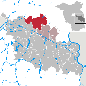
Märkisch-Oderland is a Landkreis (district) in the eastern part of Brandenburg, Germany. Neighboring this district are the district of Barnim, the country of Poland, the district-free city of Frankfurt (Oder), the district of Oder-Spree and the Bundesland of Berlin. The administrative seat is the town of Seelow but the largest town is Strausberg.

Oder-Spree is a Kreis (district) in the eastern part of Brandenburg, Germany. Neighboring are the district Märkisch-Oderland, the district-free city Frankfurt (Oder), Poland, the districts Spree-Neiße and Dahme-Spreewald, and the Bundesland Berlin.

<span class="mw-page-title-main">Eberswalde</span> Town in Brandenburg, Germany

Eberswalde is a major town and the administrative seat of the district Barnim in Brandenburg in north-eastern Germany, about 50 km (31 mi) northeast of Berlin. Population 42,144, geographical location 52°50′N13°50′E. The town is often called Waldstadt, because of the large forests around it, including the Schorfheide-Chorin Biosphere Reserve. Despite this fact, Eberswalde was an important industrial center until the German Reunification.

<span class="mw-page-title-main">Fürstenwalde</span> Town in Brandenburg, Germany

Fürstenwalde/Spree is the most populous town in the Oder-Spree District of Brandenburg, in eastern Germany.

<span class="mw-page-title-main">Rüdersdorf</span> Municipality in Brandenburg, Germany

Rüdersdorf is a municipality in the district Märkisch-Oderland, in Brandenburg, Germany, near Berlin.

<span class="mw-page-title-main">Schöneiche</span> Municipality in Brandenburg, Germany

Schöneiche is a municipality in the Oder-Spree District of Brandenburg, Germany. It is situated directly at the edge to Berlin/Friedrichshagen and next to Rüdersdorf and Woltersdorf, Brandenburg on the eastern edge of the German capital Berlin.

<span class="mw-page-title-main">Beeskow</span> Town in Brandenburg, Germany

Beeskow is a town in Brandenburg, in eastern Germany, and capital of the Oder-Spree district. It is situated on the river Spree, 30 km southwest of Frankfurt an der Oder.

<span class="mw-page-title-main">Friedland, Brandenburg</span> Town in Brandenburg, Germany

Friedland is a town in the Oder-Spree district, in Brandenburg, Germany. It is situated in the historic Lower Lusatia region, about 8 km (5.0 mi) south of Beeskow, and 39 km (24 mi) north of Cottbus.

<span class="mw-page-title-main">Storkow, Brandenburg</span> Town in Brandenburg, Germany

Storkow (Mark) is a town in Oder-Spree district, in Brandenburg, Germany. The town was the part of Brandenberg Province of Prussia, from 1815 - 1947, then it was the part of the State of Brandenburg from 1947 to 1952, Bezirk Frankfurt of East Germany from 1952 to 1990 and it again became a part of the State of Brandenburg since 1990.

<span class="mw-page-title-main">Woltersdorf, Brandenburg</span> Municipality in Brandenburg, Germany

Woltersdorf is a municipality in the Oder-Spree district in Brandenburg. It is often referred to as "near Berlin" or "near Erkner" as there are a number of other places bearing the same name in Germany.

<span class="mw-page-title-main">Gosen-Neu Zittau</span> Municipality in Brandenburg, Germany

Gosen-Neu Zittau is a municipality in the Oder-Spree district, in Brandenburg, Germany. Neu Zittau is situated in the Spree valley, near the Oder-Spree-Canal.

<span class="mw-page-title-main">Grünheide (Mark)</span> Municipality in Brandenburg, Germany

Grünheide (Mark) is a municipality in the Oder-Spree District, in Brandenburg, Germany. It is situated 30 kilometres south-east of Berlin city centre, on the River Löcknitz. In 2020 Tesla, Inc. began to build Gigafactory Berlin-Brandenburg in Grünheide near the Autobahn A10.

<span class="mw-page-title-main">Rietz-Neuendorf</span> Municipality in Brandenburg, Germany

Rietz-Neuendorf is a municipality in the Oder-Spree district, in Brandenburg, Germany

<span class="mw-page-title-main">Steinhöfel</span> Municipality in Brandenburg, Germany

Steinhöfel is a municipality in the Oder-Spree district, in Brandenburg, Germany. Since the beginning of 2019 it belongs to the collective municipality "Amt Odervorland"

Amt Spreenhagen is an Amt in the district of Oder-Spree, in Brandenburg, Germany. Its seat is in Spreenhagen.

<span class="mw-page-title-main">Dämeritzsee</span>

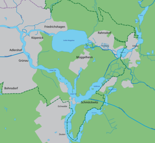
The Dämeritzsee is a lake located in Brandenburg and Berlin, Germany. At an elevation of 32 metres (105 ft), its surface area is 93.5 hectares. It is located partly in the municipality of Erkner and part in Rahnsdorf, a Berliner locality in Treptow-Köpenick district.

<span class="mw-page-title-main">Eisenhüttenstadt</span> Town in Germany

Eisenhüttenstadt is a town in the Oder-Spree district of the state of Brandenburg, in eastern Germany, on the border with Poland. East Germany founded the city in 1950. It was known as Stalinstadt (Stalinměsto) between 1953 and 1961.

<span class="mw-page-title-main">Rahnsdorf</span> Quarter of Berlin in Germany

Rahnsdorf is a locality (Ortsteil) of Berlin, Germany, located in the southeast of the Berlin borough (Bezirk) of Treptow-Köpenick. Until 2001 it was part of the former borough of Köpenick.

<span class="mw-page-title-main">Berlin/Brandenburg Metropolitan Region</span> Place in Germany

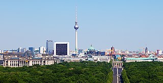
The Berlin/Brandenburg metropolitan region or capital region is one of eleven metropolitan regions of Germany, consisting of the entire territories of the state of Berlin and the surrounding state of Brandenburg. The region covers an area of 30,545 square kilometres (11,793 sq mi) with a total population of about 6.2 million.

References

  1. Landkreis Oder-Spree Wahl der Bürgermeisterin / des Bürgermeisters, accessed 2 July 2021.
  2. "Bevölkerungsentwicklung und Bevölkerungsstandim Land Brandenburg Dezember 2022" (PDF). Amt für Statistik Berlin-Brandenburg (in German). June 2023.
  3. Detailed data sources are to be found in the Wikimedia Commons.Population Projection Brandenburg at Wikimedia Commons

Commons-logo.svg Media related to Erkner at Wikimedia Commons