Woltersdorf, Brandenburg

Last updated
Woltersdorf
Ortskern von Woltersdorf bei Berlin.jpg
New commune center with the town hall in the background
Location of Woltersdorf within Oder-Spree district
Woltersdorf in LOS.pngBriesenFriedlandGrünheideStorkowVogelsangWoltersdorf
Germany adm location map.svg
Red pog.svg
Woltersdorf
Brandenburg location map.svg
Red pog.svg
Woltersdorf
Coordinates: 52°26′52″N13°45′26″E / 52.44778°N 13.75722°E / 52.44778; 13.75722 Coordinates: 52°26′52″N13°45′26″E / 52.44778°N 13.75722°E / 52.44778; 13.75722
Country Germany
State Brandenburg
District Oder-Spree
Government
   Mayor (202129) Christian Stauch [1] (SPD)
Area
  Total9.12 km2 (3.52 sq mi)
Elevation
50 m (160 ft)
Population
 (2021-12-31) [2]
  Total8,424
  Density920/km2 (2,400/sq mi)
Time zone UTC+01:00 (CET)
  Summer (DST) UTC+02:00 (CEST)
Postal codes
15569
Dialling codes 03362
Vehicle registration LOS
Website www.woltersdorf-schleuse.de

Woltersdorf is a municipality in the Oder-Spree district in Brandenburg. It is often referred to as "near Berlin" (German: "bei Berlin") or "near Erkner" (German: "bei Erkner") as there are a number of other places bearing the same name in Germany.

Contents

Geography

The municipality is located at the three lakes Flakensee, Kalksee and the Bauernsee, between Schöneiche, the Berlin forest and Erkner.

Bordering municipalities

Woltersdorf borders (in clockwise direction, starting in north) on Rüdersdorf, Erkner, Berlin and Schöneiche.

History

Around 1240 14 farmer families settled on a bank. Today the church, the city hall and the "old school" (German "alte Schule") are located here, representing the Woltersdorf "downtown". The first residents were farmers and mariners. In 1319 Woltersdorf was first documented as Waltersdorf slawika. Waltersdorf means "the village from Walter". In 1375 Woltersdorf was first noted in the "Landbuch". Together with Rahnsdorf, it paid taxes for the castle of Köpenick.

In 1487 Berlin acquired Woltersdorf. Then in 1550 a lock was built between the Flakensee and the Kalksee, the same year the first church of Woltersdorf was built. Between 1618 till 1648 Woltesdorf was desolated (Thirty Years' War) and temporarily uninhabited. About 1886 a touristic observation tower is built on top of the Kranichsberge. It granted a great perspective from a height of 105 meters, and on clear days you were able to see the Berliner Fernsehturm. Inside the tower today is an exhibition "When Woltersdorf still was Hollywood" (German "Als Woltersdorf noch Hollywood war"). It recalls the 1920s, where Joe May shot famous movies ( Das indische Grabmal (1920), Herrin der Welt (1919) and Der Tiger von Eschnapur ). Today you are able to find remains of the movie scenery on site.

At the end of the 19th century the rail from Berlin to the east was finished. In the bordering commune of Woltersdorf, Erkner, a train station was built. Many Berlin people had their summer residence in Woltersdorf. Since 1913 a tramway has run between the lock and the S-Bahn station of Rahnsdorf.

Demography

At the time of the German reunification, 4,790 people lived in Woltersdorf. Since then, the population of Woltersdorf has risen from 6,800 (2001) to nearly 8,000 (2010). Today, Woltersdorf is the youngest commune in the Oder-Spree district. More than 12% of the population is younger than 15 years of age.

Woltersdorf: Population development
within the current boundaries (2020) [3]
YearPop.±% p.a.
1875 728    
1890 1,323+4.06%
1910 2,517+3.27%
1925 3,348+1.92%
1939 6,071+4.34%
1950 6,202+0.19%
1964 6,156−0.05%
YearPop.±% p.a.
1971 6,109−0.11%
1981 5,520−1.01%
1985 5,318−0.93%
1990 4,902−1.62%
1995 5,007+0.42%
2000 6,799+6.31%
2005 7,564+2.16%
YearPop.±% p.a.
2010 7,802+0.62%
2015 8,092+0.73%
2016 8,163+0.88%
2017 8,193+0.37%
2018 8,259+0.81%
2019 8,302+0.52%
2020 8,423+1.46%

Politics

The City Council has 18 members, one however has not accepted his seat which remains vacant.

(Election 2008)

[4]

Famous Persons

Related Research Articles

Oder-Spree is a Kreis (district) in the eastern part of Brandenburg, Germany. Neighboring are the district Märkisch-Oderland, the district-free city Frankfurt (Oder), Poland, the districts Spree-Neiße and Dahme-Spreewald, and the Bundesland Berlin.

<span class="mw-page-title-main">Schönefeld</span> Municipality in Brandenburg, Germany

Schönefeld is a suburban municipality in the Dahme-Spreewald district, Brandenburg, Germany. It borders the southeastern districts of Berlin. The municipal area encompasses the old Berlin Schönefeld Airport (SXF) and the new Berlin Brandenburg Airport (BER).

<span class="mw-page-title-main">Forst (Lausitz)</span> Town in Brandenburg, Germany

Forst (Lausitz) is a town in Lower Lusatia, Brandenburg, Germany. It lies east of Cottbus, on the river Lausitzer Neiße which is also the German-Polish border, the Oder-Neisse line. It is the capital of the Spree-Neiße district. It is known for its rose garden and textile museum. The town's population is 18,651. In Forst, there is a railway bridge across the Neiße belonging to the line Cottbus–Żary which is serviced by regional trains and a EuroCity train between Hamburg and Kraków (2011). There is also a road bridge across the river north of Forst.

<span class="mw-page-title-main">Glienicke/Nordbahn</span> Municipality in Brandenburg, Germany

Glienicke/Nordbahn is a municipality in the Oberhavel district, in Brandenburg, Germany. It is located right north of Berlin.

<span class="mw-page-title-main">Spremberg</span> Town in Brandenburg, Germany

Spremberg is a municipality near the Saxon city of Hoyerswerda and is in the Spree-Neiße district of Brandenburg, Germany.

<span class="mw-page-title-main">Fürstenwalde</span> Town in Brandenburg, Germany

Fürstenwalde/Spree is the most populous town in the Oder-Spree District of Brandenburg, Germany.

<span class="mw-page-title-main">Königs Wusterhausen</span> Town in Brandenburg, Germany

Königs Wusterhausen is a town in the Dahme-Spreewald district of the state of Brandenburg in Germany a few kilometers outside Berlin.

<span class="mw-page-title-main">Rüdersdorf</span> Municipality in Brandenburg, Germany

Rüdersdorf is a municipality in the district Märkisch-Oderland, in Brandenburg, Germany, near Berlin.

<span class="mw-page-title-main">Erkner</span> Town in Brandenburg, Germany

Erkner is a town in the Oder-Spree District of Brandenburg, Germany, located on the south-eastern edge of the German capital city Berlin.

<span class="mw-page-title-main">Schöneiche</span> Municipality in Brandenburg, Germany

Schöneiche is a municipality in the Oder-Spree District of Brandenburg, Germany. It is situated directly at the edge to Berlin/Friedrichshagen and next to Rüdersdorf and Woltersdorf, Brandenburg on the eastern edge of the German capital Berlin.

<span class="mw-page-title-main">Wiesenburg</span> Municipality in Brandenburg, Germany

Wiesenburg is a municipality in the Potsdam-Mittelmark district, in Brandenburg, Germany. It is situated 10 km west of Bad Belzig, and 34 km southwest of Brandenburg. It is located in the High Fläming Nature Park.

<span class="mw-page-title-main">Friedland, Brandenburg</span> Town in Brandenburg, Germany

Friedland is a town in the Oder-Spree district, in Brandenburg, Germany. It is situated in the historic Lower Lusatia region, about 8 km (5.0 mi) south of Beeskow, and 39 km (24 mi) north of Cottbus.

<span class="mw-page-title-main">Storkow, Brandenburg</span> Town in Brandenburg, Germany

Storkow (Mark) is a town in Oder-Spree district, in Brandenburg, Germany.

<span class="mw-page-title-main">Kremmen</span> Town in Brandenburg, Germany

Kremmen is a town in the district of Oberhavel, in Brandenburg, Germany. It is located 15 km west of Oranienburg and 38 km northwest of Berlin. It is known mostly for its castle Ziethen. The local church contains an organ built in 1817 by Tobias Thurley.

<span class="mw-page-title-main">Zeuthen</span> Municipality in Brandenburg, Germany

Zeuthen is a municipality in the district of Dahme-Spreewald in Brandenburg in Germany.

<span class="mw-page-title-main">Grünheide (Mark)</span> Municipality in Brandenburg, Germany

Grünheide (Mark) is a municipality in the Oder-Spree District, in Brandenburg, Germany. It is situated 30 kilometres south-east of Berlin city centre, on the River Löcknitz. In 2020 Tesla, Inc. began to build Gigafactory Berlin-Brandenburg in Grünheide near the Autobahn A10.

<span class="mw-page-title-main">Dämeritzsee</span> Body of water

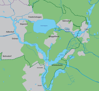
The Dämeritzsee is a lake located in Brandenburg and Berlin, Germany. At an elevation of 32 metres (105 ft), its surface area is 93.5 hectares. It is located partly in the municipality of Erkner and part in Rahnsdorf, a Berliner locality in Treptow-Köpenick district.

<span class="mw-page-title-main">Berlin-Rahnsdorf station</span>

Rahnsdorf station is a station of the Berlin S-Bahn. It is located in the district of Rahnsdorf in the Berlin district of Treptow-Köpenick.

<span class="mw-page-title-main">Berlin Wilhelmshagen station</span>

Berlin Wilhelmshagen station is located on the Berlin-Frankfurt (Oder) railway and the Berlin S-Bahn. It is located in the settlement of Wilhelmshagen in the suburb of Rahnsdorf in the district of Treptow-Köpenick and is the last stop in the suburbs of Berlin of the line to Erkner. It is served by the S-Bahn line S3.

<span class="mw-page-title-main">Rahnsdorf</span> Quarter of Berlin in Germany

Rahnsdorf is a locality (Ortsteil) of Berlin, Germany, located in the southeast of the Berlin borough (Bezirk) of Treptow-Köpenick. Until 2001 it was part of the former borough of Köpenick.

References

  1. Landkreis Oder-Spree Wahl der Bürgermeisterin / des Bürgermeisters, accessed 13 November 2022.
  2. "Bevölkerungsentwicklung und Flächen der kreisfreien Städte, Landkreise und Gemeinden im Land Brandenburg 2021" (PDF). Amt für Statistik Berlin-Brandenburg (in German). June 2022.
  3. Detailed data sources are to be found in the Wikimedia Commons.Population Projection Brandenburg at Wikimedia Commons
  4. Results of election 25 May 2014