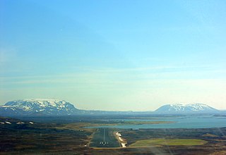
Raufarhöfn Airport

Last updated
Raufarhöfn Airport
Summary
Airport type Public
Serves Raufarhöfn
Elevation  AMSL 39 ft / 12 m
Coordinates 66°24′25″N15°55′30″W / 66.40694°N 15.92500°W / 66.40694; -15.92500 Coordinates: 66°24′25″N15°55′30″W / 66.40694°N 15.92500°W / 66.40694; -15.92500
Map
Iceland adm location map.svg
Airplane silhouette.svg
RFN
Location of the airport in Iceland
Runways
Direction Length Surface
m ft
07/25 1,175 3,855 Asphalt
15/33 634 2,080 Asphalt
Source: Google Maps [1] GCM [2]

Raufarhöfn Airport( IATA : RFN, ICAO : BIRG) is an airport serving Raufarhöfn, Iceland. The runways are 5 kilometres (3.1 mi) south of the town.

An IATA airport code, also known as an IATA location identifier, IATA station code or simply a location identifier, is a three-letter code designating many airports around the world, defined by the International Air Transport Association (IATA). The characters prominently displayed on baggage tags attached at airport check-in desks are an example of a way these codes are used.

ICAO airport code four-letter code designating many airports around the world

The ICAOairport code or location indicator is a four-letter code designating aerodromes around the world. These codes, as defined by the International Civil Aviation Organization and published in ICAO Document 7910: Location Indicators, are used by air traffic control and airline operations such as flight planning.

Raufarhöfn Village in Northeast Constituency, Iceland

Raufarhöfn is a village located on the northeastern tip of the Melrakkaslétta peninsula in Iceland. At one point in time, this small village was home to largest export harbor in Iceland. In the forties and fifties, the Herring frenzy dominated the Icelandic economy and Raufarhöfn was an important place in that economic chain. But after the herring disappeared the effect was devastating for the village. This is the reason for the old and interesting factory buildings. The village is the site of a modern monument called the "Arctic Henge" which is aligned to the heavens and is inspired by the mythical world of the Eddic poem Völuspá . As of 2019, it has 188 inhabitants. It was a major fish processing station during the large herring catches in the mid 20th century.

Contents

The Raufarhöfn non-directional beacon (Ident: RA) is located 2.8 nautical miles north-northwest of the airport. [3] [4]

Non-directional beacon radio transmitter which emits radio waves in all directions

A non-directional (radio) beacon (NDB) is a radio transmitter at a known location, used as an aviation or marine navigational aid. As the name implies, the signal transmitted does not include inherent directional information, in contrast to other navigational aids such as low frequency radio range, VHF omnidirectional range (VOR) and TACAN. NDB signals follow the curvature of the Earth, so they can be received at much greater distances at lower altitudes, a major advantage over VOR. However, NDB signals are also affected more by atmospheric conditions, mountainous terrain, coastal refraction and electrical storms, particularly at long range.

See also

Related Research Articles

Grímsey Airport airport in Iceland

Grímsey Airport is an airport serving Grímsey, a small island 40 kilometres (25 mi) north of Iceland.

Patreksfjörður Airport airport in Iceland

Patreksfjörður Airport or Patreksfjordur Airport is an airport serving Patreksfjörður, Iceland. The airport is across the fjord, 4.8 kilometres (3.0 mi) south of the town.

Siglufjörður Airport or Siglufjordur Airport is an airport serving Siglufjörður, Iceland.

Bíldudalur Airport airport

Bíldudalur Airport is an airport serving Bíldudalur, a village in the Vesturbyggð municipality in the Westfjords of Iceland. The runway is 5 kilometres (3.1 mi) south-southeast of the village.

Bakki Airport airport

Bakki Airport is an airport on the southern coast of Iceland, used mainly for short-haul flights to and from the Westman Islands.

Selfoss Airport airport in Iceland

Selfoss Airport is an airport serving Selfoss, a town on the banks of Ölfusá river in the Árborg municipality in southern Iceland. Selfoss Airport is privately owned.

Gjögur Airport airport in Iceland

Gjögur Airport is an airport serving the small population of the Árneshreppur district in the Westfjords of north-west Iceland, on the coast of Húnaflói bay. It is staffed part-time by an AFIS controller, and only opens for Flugfélag Ernir flights, which are twice a week in the winter and once a week in the summer.

Sauðárkrókur Airport airport in Iceland

Sauðárkrókur Airport is an airport serving Sauðárkrókur, a village on the Skagafjörður bay in northern Iceland.

Djúpivogur Airport airport in Iceland

Djúpivogur Airport is an airport serving Djúpivogur, Iceland.

Norðfjörður Airport

Norðfjörður Airport is an airport serving Neskaupstaður, Iceland. The town is on the Norðfjörður fjord.

Stykkishólmur Airport airport in Iceland

Stykkishólmur Airport is an airport serving Stykkishólmur, Iceland.

Þingeyri Airport airport in Thingeyri, Iceland

Þingeyri Airport is an airport serving Þingeyri (Thingeyri), Iceland.

Mývatn Airport airport in Iceland

Mývatn Airport is an airport serving Reykjahlíð, Iceland.

Fáskrúðsfjörður Airport airport in Iceland

Fáskrúðsfjörður Airport is an airport serving Fáskrúðsfjörður, Iceland.

Fagurhólsmýri Airport airport in Iceland

Fagurhólsmýri Airport is an airport serving Fagurhólsmýri, Iceland.

Kópasker Airport airport in Iceland

Kópasker Airport is an airport serving the coastal village of Kópasker, Iceland.

Grundarfjörður Airport airport in Iceland

Grundarfjörður Airport is an airport serving Grundarfjörður, Iceland. The airport is on a peninsula 8 kilometres (5.0 mi) north of the town.

Hólmavík Airport airport in Iceland

Hólmavík Airport is an airport serving Hólmavík, Iceland.

References