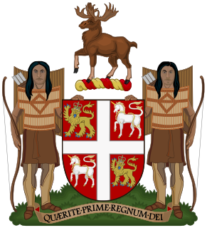
The Newfoundland and Labrador House of Assembly is the unicameral deliberative assembly of the General Assembly of Newfoundland and Labrador of the province of Newfoundland and Labrador, Canada. It meets in the Confederation Building at St. John's. Bills passed by the assembly are given royal assent by the Queen of Canada in Right of Newfoundland and Labrador, represented by the Lieutenant Governor of Newfoundland and Labrador.
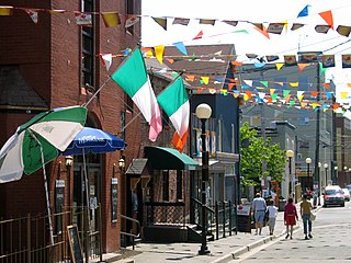
George Street is a small street located in St. John's, Newfoundland and Labrador, that is known for its many bars and pubs. The two-block long street houses nothing but bars, pubs and restaurants.

Water Street is located in downtown St. John's, Newfoundland and Labrador, Canada. It became a commercial trading outpost for the Basques, French, Spanish, Portuguese, and English. The street now boasts many souvenir shops, restaurants, pubs, and high-end boutiques, as well as other commercial ventures. To this day the street remains the hub of commercial activity in the city and in 2020 the city implemented a temporary pedestrian-only section of the road.

Edward Welby Pugin was an English architect, the eldest son of architect Augustus Welby Northmore Pugin and Louisa Barton and part of the Pugin & Pugin family of church architects. His father was an architect and designer of Neo-Gothic architecture, and after his death in 1852 Edward took up his successful practice. At the time of his own early death in 1875, Pugin had designed and completed more than one hundred Catholic churches.

The Burin Peninsula is a peninsula located on the south coast of the island of Newfoundland in the province of Newfoundland and Labrador.
St. Patrick's Park is the largest baseball park in the province of Newfoundland and Labrador. It is located in St. John's, Newfoundland and was built by American servicemen stationed in the province following the Second World War.

Pippy Park is a 3,400-acre (14 km2) urban park located in the city of St. John's, Newfoundland. It is the second largest provincially-managed urban park in Canada, after Fish Creek Provincial Park in Calgary, Alberta. The park is a popular camping, hiking and recreational park within the city, and incorporates numerous groomed and wilderness-style hiking/skiing trails, a miniature golf course, a 9-hole and an 18-hole golf course, a driving range, and a public access trailer park with limited tent camping facilities. Trails within the park link to the Grand Concourse walking trails.

Rabbittown is a neighbourhood in St. John's, Newfoundland and Labrador. It is located near downtown, and is bounded approximately by Empire Avenue, Freshwater Road and Newtown Road.

Johnny Burke (1851–1930) was a Newfoundland poet, singer, songwriter, and musician from St. John's, where he lived all his life. He was nicknamed the Bard of Prescott Street and wrote many popular songs that were released by folk singers in the 1930s and 1940s.
Interstate 80 (I-80) is a part of the Interstate Highway System that runs from San Francisco to Teaneck, New Jersey. In Wyoming, the Interstate Highway runs 402.780 miles (648.212 km) from the Utah state line near Evanston east to the Nebraska state line in Pine Bluffs. I-80 connects Cheyenne, Wyoming's capital and largest city, with several smaller cities along the southern tier of Wyoming, including Evanston, Green River, Rock Springs, Rawlins, and Laramie. The highway also connects those cities with Salt Lake City to the west and Omaha to the east. In Cheyenne, I-80 intersects I-25 and has Wyoming's only auxiliary Interstate, I-180. The Interstate runs concurrently with U.S. Route 30 for most of their courses in Wyoming. I-80 also has shorter concurrencies with US 189 near Evanston, US 191 near Rock Springs, and US 287 and Wyoming Highway 789 near Rawlins. The Interstate has business loops through all six cities along its course as well as a loop serving Fort Bridger and Lyman east of Evanston.

Georgestown is a Neighbourhood Improvement Area in St. John's, Newfoundland and Labrador a short distance north from downtown of St. John's. This was established in the 1970s as part of an effort by Federal and local government to improve inner cities. Originally what was known as Georgestown village was much smaller and only "extended from Donnelly's Lane to what is now Belvedere Street". The neighbourhood improvement area includes, in addition to the original Georgestown, the former Monkstown and Tubridtown, along with adjoining land, including Circular Road, and Belvedere Street as well as some other parts of the former Belvedere Estate. It is bordered by Military Road, Monkstown Road, Empire Avenue, a small part of Carpasian Road, the east side of Bonaventure Avenue, and Holy Heart and Brother Rice Schools to the west. It was settled, around 1819, as the city's first suburb. The name is an evolution of "George (Winter)'s Town", as it was known in the 19th century.

Bannerman Park is a Victorian era urban park located in St. John's, Newfoundland and Labrador. The park is named for Sir Alexander Bannerman, Governor of the Colony of Newfoundland from 1857 to 1864, who assented to an Act establishing the park and donated land for the purpose in 1864. The park occupies the city block bounded by Bannerman Road, Military Road, Rennie's Mill Road, and Circular Road excluding several residential lots carved out of the southwest corner.

Shearstown is a settlement in Newfoundland and Labrador. It is part of the Town of Bay Roberts. Shearstown Brook runs through the community to the Shearstown Estuary, then flowing into Spaniard's Bay. The brook valley consists largely of terraced sand and gravel deposits, likely deposited in an ice-distal glaciofluvial environment.

The Detroit Financial District is a United States historic district in downtown Detroit, Michigan. The district was listed on the U.S. National Register of Historic Places on December 14, 2009, and was announced as the featured listing in the National Park Service's weekly list of December 24, 2009.
Ayre & Sons, Ltd. was a department store chain in Newfoundland, Canada. The chain was formed in 1859 in St. John's, Newfoundland by Charles R. Ayre. Ayre opened his flagship store on Water Street in St. John's in 1859. After Newfoundland joined the Canadian confederation in 1949, Ayre's opened some more stores across the province in the 1960s, with locations in Mount Pearl, Carbonear, Corner Brook, and Wabush. A location in the Avalon Mall in St. John's also opened when the mall opened in 1967. However, the company began to encounter financial problems in the 1980s, and in 1991, Ayre and Sons filed for bankruptcy.
Shea Heights is a small neighborhood located in the hills of St. John's, Newfoundland and Labrador, Canada.

Division No. 1, Subdivision G is an unorganized subdivision on the Avalon Peninsula in Newfoundland and Labrador, Canada. It is in Division 1 and contains the unincorporated communities of Baccalieu Island, Besom Cove, Bradley's Cove, Burnt Point, Caplin Cove, Daniel's Cove, Grates Cove, Gull Island, Job's Cove, Kingston, Long Beach, Lower Island Cove, Low Point, Northern Bay, Ochre Pit Cove, Red Head Cove, Riverhead, Smooth Cove and Western Bay.
Robert Oke, H.M. was the first chief inspector for the Newfoundland Lighthouse Service and served from at least 1848 to 1870. Oke installed the first light mechanism at the Cape Bonavista Light in 1842, and installed the famous Isle of May light mechanism at the Cape Pine Light in 1850, which was later moved to Harbour Grace Island and finally to Cape Bonavista, where it can be viewed today.
Harris Rendell Oke, CMG, MC and Bar was a wounded veteran of World War I who became Colonial Secretary, The Gambia, British West Africa (1934–1940) and served as its Acting Governor and Commander-in-Chief for six extended periods between 1934 and 1940.
