
The Congregation of Saint Michael the Archangel (CSMA), also known as the Michaelite Fathers, is a religious institute of the Roman Catholic Church founded in 1897 by the Blessed Father Bronisław Markiewicz, a Polish priest from Miejsce Piastowe, Poland. The Congregation of Saint Michael the Archangel is one of the 30 officially recognized groups of the Salesian Family of Don Bosco.

Shahumyan is a town in the Yerevan Province of Armenia. The town was named after Stepan Shahumyan, a Bolshevik commissar.
Krugło is a village in the administrative district of Gmina Dąbrowa Białostocka, within Sokółka County, Podlaskie Voivodeship, in north-eastern Poland.

Bochowo is a village in the administrative district of Gmina Czarna Dąbrówka, within Bytów County, Pomeranian Voivodeship, in northern Poland. It lies approximately 11 kilometres (7 mi) east of Czarna Dąbrówka, 30 km (19 mi) north-east of Bytów, and 60 km (37 mi) west of the regional capital Gdańsk.
Ostrów is a village in the administrative district of Gmina Grabica, within Piotrków County, Łódź Voivodeship, in central Poland. It lies approximately 5 kilometres (3 mi) south of Grabica, 12 km (7 mi) north-west of Piotrków Trybunalski, and 37 km (23 mi) south of the regional capital Łódź.
Emilia is a village in the administrative district of Gmina Zgierz, within Zgierz County, Łódź Voivodeship, in central Poland. It lies approximately 10 kilometres (6 mi) north-west of Zgierz and 18 km (11 mi) north-west of the regional capital Łódź.

Center Valley is a small unincorporated farming community in the town of Center in Outagamie County, Wisconsin, United States. Center Valley lies 5 miles (8.0 km) north of the City of Appleton, and is served by the post office of Black Creek, which has the ZIP code 54106.
Kamionka is a village in the administrative district of Gmina Glinojeck, within Ciechanów County, Masovian Voivodeship, in east-central Poland.
Kamianka is a village in the administrative district of Gmina Nur, within Ostrów Mazowiecka County, Masovian Voivodeship, in east-central Poland.
Golice-Kolonia is a village in the administrative district of Gmina Siedlce, within Siedlce County, Masovian Voivodeship, in east-central Poland.
Pilawice is a village in the administrative district of Gmina Sochaczew, within Sochaczew County, Masovian Voivodeship, in east-central Poland.
Wygoda is a settlement in the administrative district of Gmina Kazimierz Biskupi, within Konin County, Greater Poland Voivodeship, in west-central Poland.
Ostrowo Szlacheckie is a village in the administrative district of Gmina Września, within Września County, Greater Poland Voivodeship, in west-central Poland.
Tyń is a village in the administrative district of Gmina Postomino, within Sławno County, West Pomeranian Voivodeship, in north-western Poland. It lies approximately 5 kilometres (3 mi) south of Postomino, 11 km (7 mi) north of Sławno, and 183 km (114 mi) north-east of the regional capital Szczecin.
Lệ Viễn is a commune (xã) and village in Sơn Động District, Bắc Giang Province, in northeastern Vietnam.

Pind Sawikaand Bair Faqiran are towns in Jhelum District of Punjab, Pakistan. It is part of Jhelum Tehsil. It is located at the right bank of the Bunhar River and at starting of Tilla Jogian mountain range, where the Tilla Satellite Launch Center is located. As Geography these are two separate towns but economics situation is so different Bair Faqiran and Pind Swika. The Pind sawika is avail some facilities but Bair Faqiran town is with out all basic facilities. As per geography these two towns are need facilities.
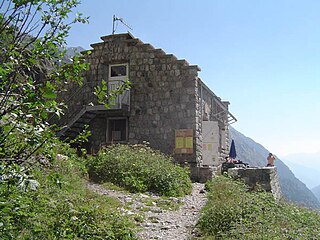
Refuge des Bans is a refuge in the Alps in France.
Uljaste is a village in Lüganuse Parish, Ida-Viru County in northeastern Estonia.
Oudeland is a neighborhood of Rotterdam, Netherlands.

Canillas is a ward (barrio) of Madrid belonging to the district of Hortaleza.


