
Kansas City is the largest city in Missouri by population and area. As of the 2020 census, the city had a population of 508,090 in 2020, making it the 36th most-populous city in the United States. It is the central city of the Kansas City metropolitan area, which straddles the Missouri–Kansas state line and has a population of 2,392,035. Most of the city lies within Jackson County, with portions spilling into Clay, Cass, and Platte counties. Kansas City was founded in the 1830s as a port on the Missouri River at its confluence with the Kansas River coming in from the west. On June 1, 1850, the town of Kansas was incorporated; shortly after came the establishment of the Kansas Territory. Confusion between the two ensued, and the name Kansas City was assigned to distinguish them soon after.
Platte County is a county located in the northwestern portion of the U.S. state of Missouri and is part of the Kansas City metropolitan area. As of the 2020 census, the population was 106,718. Its county seat is Platte City. The county was organized December 31, 1838, from the Platte Purchase, named for the Platte River. The Kansas City International Airport is located in the county, approximately one mile west of Interstate 29 between mile markers 12 and 15. The land for the airport was originally in an unincorporated portion of Platte County before being annexed by Platte City, and eventually Kansas City.

Kansas City, abbreviated as "KCK", is the third-largest city in the U.S. state of Kansas, and the county seat of Wyandotte County. It is an inner suburb of the older and more populous Kansas City, Missouri, after which it is named. As of the 2020 census, the population of the city was 156,607, making it one of four principal cities in the Kansas City metropolitan area. It is situated at Kaw Point, the junction of the Missouri and Kansas rivers. It is part of a consolidated city-county government known as the "Unified Government". It is the location of the University of Kansas Medical Center and Kansas City Kansas Community College.

Claycomo is a village in Clay County, Missouri, United States, as part of the Kansas City metropolitan area. Its name is a portmanteau of "Clay County, MO". The population was 1,343 at the 2020 census. Ford Motor Company owns the Kansas City Assembly Plant (KCAP) in Claycomo, which builds the Ford F-150 pickup trucks and Ford Transit vans.

Gladstone is a city in Clay County, Missouri, United States and a suburb of Kansas City. The City of Gladstone is located only 10 minutes from downtown Kansas City, and 10 minutes from Kansas City International Airport. As of the 2020 census, the city population was 27,063. It is part of the Kansas City metropolitan area.

North Kansas City is a city in Clay County, Missouri, United States. It is also enclaved in Kansas City. Even though the name is similar to its larger counterpart, Kansas City, it is an independent municipality part of the Kansas City metropolitan area. The population was 4,467 at the 2020 census. Originally a northern suburb across the Missouri River from Kansas City, it is now almost completely surrounded by Kansas City, which has annexed far to the north of North Kansas City's northern city limits. North Kansas City also adjoins the small municipality of Avondale.

Grain Valley is a city in Jackson County, Missouri, United States. Grain Valley is located in the Kansas City Metropolitan Area and is a suburb of Kansas City. The population was 12,854 at the 2010 census and an estimated 14,526 in 2019. It is 23 miles (37 km) east of downtown Kansas City.
Grandview is a city in Jackson County, Missouri, United States. The population was 24,475 at the 2010 census. It is part of the Kansas City metropolitan area.

Lone Jack is a city in Jackson County, Missouri, United States. The population was 1,050 at the 2010 U.S. Census. It is part of the Kansas City metropolitan area.

Parkville is a city in Platte County, Missouri, United States and is a part of the Kansas City Metropolitan Area. The population was 7,177 at the 2020 census. Parkville is known for its antique shops, art galleries, and historic downtown. The city is home to Park University, English Landing Park, Platte Landing Park, and the National Golf Club of Kansas City. Large neighborhoods in Parkville include: Riss Lake, The National, Thousand Oaks, Creekside, Parkville Heights, River Hills, Riverchase, The Bluffs, Downtown, and Pinecrest.
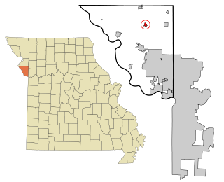
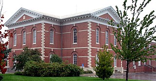
Camden Point is a city in Platte County, Missouri, United States and is part of the Kansas City metropolitan area. The population was 474 at the 2010 census.

Independence is the fifth-largest city in Missouri and the county seat of Jackson County. Independence is a satellite city of Kansas City, Missouri, and is the largest suburb on the Missouri side of the Kansas City metropolitan area. In 2020, it had a total population of 123,011.

Oak Grove is a city in Jackson and Lafayette counties in the U.S. state of Missouri. The population was 7,795 at the 2010 census. It is part of the Kansas City metropolitan area.

The Kansas City metropolitan area is a bi-state metropolitan area anchored by Kansas City, Missouri. Its 14 counties straddle the border between the U.S. states of Missouri and Kansas. With 8,472 square miles (21,940 km2) and a population of more than 2.2 million people, it is the second-largest metropolitan area centered in Missouri and is the largest metropolitan area in Kansas, though Wichita is the largest metropolitan area centered in Kansas. Alongside Kansas City, Missouri, these are the suburbs with populations above 100,000: Overland Park, Kansas; Kansas City, Kansas; Olathe, Kansas; Independence, Missouri; and Lee's Summit, Missouri.

The 3-Trails Crossing Memorial Highway is the official name for an interchange in south Kansas City, Missouri that was once considered one of Missouri's most congested locations. Although it is known as Grandview Triangle, it is not located in Grandview, a suburb of Kansas City. It is actually north of Grandview, still within the city limits of Kansas City. After several years of reconstruction, the interchange itself is largely congestion free during non-peak hours despite the high traffic on the highways approaching the interchange. During rush-hour moderate to major delays and numerous accidents are reported.
Waldo is a neighborhood located on the southside of Kansas City, Missouri, that has continued to maintain its own unique character, even though it was annexed by Kansas City in 1909. Waldo's boundaries are Gregory Boulevard on the north to 85th Street on the south, and Holmes Street on the east to State Line on the west.
Stilwell is an unincorporated community in Johnson County, Kansas, United States, and part of the Kansas City metropolitan area. The ZIP Code for Stilwell is 66085.

Ward Parkway is a boulevard in Kansas City, Missouri, United States, near the Kansas-Missouri state line. Ward Parkway begins at Brookside Boulevard on the eastern edge of the Country Club Plaza and continues westward along Brush Creek as U.S. Route 56 until it turns southward across the creek just before the Kansas-Missouri state line. It then continues south for four miles, terminating at Wornall Road near West 95th Street.
Dayton is an unincorporated community in southeast Cass County, in the U.S. state of Missouri. Garden City is five miles north along Missouri Route F and Creighton lies 6.5 miles east along Missouri Route B. The Settles Ford Conservation Area along the South Grand River lies to the southeast. The community lies atop a ridge between Sugar Creek to the west and Lick Branch to the east. It is part of the Kansas City metropolitan area.
Holmes Park is a neighborhood of Kansas City, Missouri, United States.
