
The Panama Canal is an artificial 82-kilometre (51-mile) waterway in Panama that connects the Atlantic Ocean with the Pacific Ocean, cutting across the Isthmus of Panama, and is a conduit for maritime trade. Canal locks at each end lift ships up to Gatun Lake, an artificial freshwater lake 26 meters (85 ft) above sea level, created by damming up the Chagres River and Lake Alajuela to reduce the amount of excavation work required for the canal, and then lower the ships at the other end. An average of 200,000,000 L (52,000,000 US gal) of fresh water are used in a single passing of a ship.
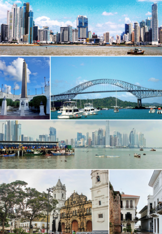
Panama City, also known as Panama, is the capital and largest city of Panama. It has a total population of 1,938,000, with over 1,500,000 in its urban area. The city is located at the Pacific entrance of the Panama Canal, in the province of Panama. The city is the political and administrative center of the country, as well as a hub for banking and commerce.
Concepción is a city and commune in south-central Chile, and the geographical and demographic core of the Greater Concepción metropolitan area, one of the three major conurbations in the country. It has a significant impact on domestic trade being part of the most heavily industrialized region in the country. It is the seat of the Concepción Province and the capital of the Bío Bío Region. It sits about 500 km south of the nation's capital, Santiago.

Whitman is a town in Plymouth County, Massachusetts, United States. The population was 15,121 at the 2020 census. It is notable as being the place where the chocolate chip cookie was invented.

The Panama Canal Zone, also simply known as the Canal Zone, was a concession of the United States located in the Isthmus of Panama that existed from 1903 to 1979. It consisted of the Panama Canal and an area generally extending five miles (8 km) on each side of the centerline, but excluding Panama City and Colón. Its capital was Balboa.

Colón is a city and seaport in Panama, beside the Caribbean Sea, lying near the Atlantic entrance to the Panama Canal. It is the capital of Panama's Colón Province and has traditionally been known as Panama's second city. Originally it was located entirely on Manzanillo Island, surrounded by Limon Bay, Manzanillo Bay, and the Folks River; however, since the disestablishment of the Panama Canal Zone, the city's limits have been redefined to include Fort Gulick, a former U.S. Army base, as well the former Panama Canal Zone towns of Cristobal, Margarita, and Coco Solo.

Saint Thomas is one of the Virgin Islands in the Caribbean Sea, and a constituent district of the United States Virgin Islands (USVI), an unincorporated territory of the United States. Along with surrounding minor islands, it is one of three county-equivalents in the USVI. Together with Saint John, it forms one of the districts of the USVI. The territorial capital and port of Charlotte Amalie is located on the island. As of the 2020 census, the population of Saint Thomas was 42,261, about 48.5% of the total population of the United States Virgin Islands. The island has a land area of 32 square miles (83 km2).

San Pedro, officially the City of San Pedro, is a 3rd class component city in the province of Laguna, Philippines. According to the 2020 census, it has a population of 326,001 people.

Arthur S. Taylor Jr. was an American jazz drummer, who "helped define the sound of modern jazz drumming".

Sagay, officially the City of Sagay, is a 3rd class component city in the province of Negros Occidental, Philippines. According to the 2020 census, it has a population of 148,894 people.

Koronadal, officially the City of Koronadal, also known as Marbel, is a 3rd class component city and capital of the province of South Cotabato, Philippines. According to the 2020 census, it has a population of 195,398 people.

Magalang, officially the Municipality of Magalang, is a 1st class municipality in the province of Pampanga, Philippines. According to the 2020 census, it has a population of 124,188 people.

The idea of the Panama Canal dates back to 1513, when Vasco Núñez de Balboa first crossed the Isthmus of Panama. This narrow land bridge between North and South America was a fine location to dig a water passage between the Atlantic and Pacific Oceans. The earliest European colonists recognized this, and several proposals for the construction of a canal were made.
Rainbow City, now known as the sector Arco Iris, in the corregimiento Cristóbal, is a section of the city of Colón in the Republic of Panama. It was originally built as segregated housing for Panama Canal employees and was developed into a proper town by the Canal Zone Government. During over a century of history, Rainbow City was home to some of Panama Canal's teachers, workers, and athletes.

Gamboa is a small town in corregimiento of Cristóbal in the Colón Province, Panama close to the Panama Canal and the Chagres River. It was one of a handful of permanent Canal Zone townships, built to house employees of the Panama Canal and their dependents. The name Gamboa is the name of a tree of the quince family.

Paraíso is a town in the Republic of Panama, located just north of the Panama Canal's Pedro Miguel Locks. It was a vibrant township of the old Canal Zone, though it was segregated for most of its history.

Cristóbal is a port town and corregimiento in Colón District, Colón Province, Panama. The corregimiento has a population of 49,422 as of 2010. The town is located on the western edge of Manzanillo Island, on the Atlantic side of the Panama Canal. Cristóbal Colón is the Spanish translation for Christopher Columbus, the Genovese explorer for whom these places were named.

Balboa High School was a public high school in the former Canal Zone on the isthmus of Panama. It was a part of the Department of Defense Education Activity (DoDEA).

Gatun is a small town on the Atlantic Side of the Panama Canal, located south of the city of Colón at the point in which Gatun Lake meets the channel to the Caribbean Sea. The town is best known as the site of the Panama Canal's Gatun Locks and Gatun Dam, built by the United States between 1906–1914.

John Geronald Claybourn was a civil engineer and Dredging Division Superintendent of the Isthmian Canal Commission. He was the original designer of Gamboa, Panama. During his career on the Panama Canal and after his retirement, Claybourn was involved as a consultant in river and harbor improvement projects in several countries, primarily in Latin America.
