Related Research Articles

In aviation, instrument flight rules (IFR) is one of two sets of regulations governing all aspects of civil aviation aircraft operations; the other is visual flight rules (VFR).
In aviation, visual flight rules (VFR) are a set of regulations under which a pilot operates an aircraft in weather conditions generally clear enough to allow the pilot to see where the aircraft is going. Specifically, the weather must be better than basic VFR weather minima, i.e., in visual meteorological conditions (VMC), as specified in the rules of the relevant aviation authority. The pilot must be able to operate the aircraft with visual reference to the ground, and by visually avoiding obstructions and other aircraft.

Air traffic control (ATC) is a service provided by ground-based air traffic controllers who direct aircraft on the ground and through a given section of controlled airspace, and can provide advisory services to aircraft in non-controlled airspace. The primary purpose of ATC is to prevent collisions, organize and expedite the flow of traffic in the air, and provide information and other support for pilots.

In aviation, a flight level (FL) is an aircraft's altitude as determined by a pressure altimeter using the International Standard Atmosphere. It is expressed in hundreds of feet or metres. The altimeter setting used is the ISA sea level pressure of 1013 hPa or (29.92 inHg). The actual surface pressure will vary from this at different locations and times. Therefore, by using a standard pressure setting, every aircraft has the same altimeter setting, and vertical clearance can be maintained during cruise flight.

In aviation, visual meteorological conditions (VMC) is an aviation flight category in which visual flight rules (VFR) flight is permitted—that is, conditions in which pilots have sufficient visibility to fly the aircraft maintaining visual separation from terrain and other aircraft. They are the opposite of instrument meteorological conditions (IMC). The boundary criteria between IMC and VMC are known as the VMC minima and are defined by: visibility, cloud ceilings, and cloud clearances.
Reduced vertical separation minimum (RVSM) is the reduction, from 2,000 feet to 1,000 feet, of the standard vertical separation required between aircraft flying between flight level 290 (29,000 ft) and flight level 410 (41,000 ft). This reduction in vertical separation minimum therefore increases the number of aircraft that can fly in a particular volume of controlled airspace.

In aviation, instrument meteorological conditions (IMC) are weather conditions that require pilots to fly primarily by reference to flight instruments, and therefore under instrument flight rules (IFR), as opposed to flying by outside visual references under visual flight rules (VFR). Typically, this means flying in cloud or poor weather, where little or nothing can be seen or recognised when looking out of the window. Simulated IMC can be achieved for training purposes by wearing view-limiting devices, which restrict outside vision and force the trainee to rely on instrument indications only.

In aviation, an instrument approach or instrument approach procedure (IAP) is a series of predetermined maneuvers for the orderly transfer of an aircraft operating under instrument flight rules from the beginning of the initial approach to a landing, or to a point from which a landing may be made visually. These approaches are approved in the European Union by EASA and the respective country authorities and in the United States by the FAA or the United States Department of Defense for the military. The ICAO defines an instrument approach as "a series of predetermined maneuvers by reference to flight instruments with specific protection from obstacles from the initial approach fix, or where applicable, from the beginning of a defined arrival route to a point from which a landing can be completed and thereafter, if landing is not completed, to a position at which holding or en route obstacle clearance criteria apply."
Required navigation performance (RNP) is a type of performance-based navigation (PBN) that allows an aircraft to fly a specific path between two 3D-defined points in space.
The Future Air Navigation System (FANS) is an avionics system which provides direct data link communication between the pilot and the air traffic controller. The communications include air traffic control clearances, pilot requests and position reporting. In the FANS-B equipped Airbus A320 family aircraft, an Air Traffic Services Unit (ATSU) and a VHF Data Link radio (VDR3) in the avionics rack and two data link control and display units (DCDUs) in the cockpit enable the flight crew to read and answer the controller–pilot data link communications (CPDLC) messages received from the ground.
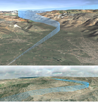
The North Atlantic Tracks, officially titled the North Atlantic Organised Track System (NAT-OTS), are a structured set of transatlantic flight routes that stretch from eastern North America to western Europe across the Atlantic Ocean, within the North Atlantic airspace region. They ensure that aircraft are separated over the ocean, where there is little radar coverage. These heavily travelled routes are used by aircraft flying between North America and Europe, operating between the altitudes of 29,000 and 41,000 ft inclusive. Entrance and movement along these tracks is controlled by special oceanic control centres to maintain separation between aircraft. The primary purpose of these routes is to allow air traffic control to effectively separate the aircraft. Because of the volume of NAT traffic, allowing aircraft to choose their own co-ordinates would make the air traffic control (ATC) task far more complex. They are aligned in such a way as to minimize any head winds and maximize tail winds impact on the aircraft. This results in much more efficiency by reducing fuel burn and flight time. To make such efficiencies possible, the routes are created twice daily to take account of the shifting of the winds aloft and the principal traffic flow, eastward in North America evening and westward twelve hours later.

Area navigation is a method of instrument flight rules (IFR) navigation that allows an aircraft to choose any course within a network of navigation beacons, rather than navigate directly to and from the beacons. This can conserve flight distance, reduce congestion, and allow flights into airports without beacons. Area navigation used to be called "random navigation", hence the acronym RNAV.

In air traffic control, separation is the name for the concept of keeping an aircraft outside a minimum distance from another aircraft to reduce the risk of those aircraft colliding, as well as prevent accidents due to secondary factors, such as wake turbulence. Separation can also apply to terrain, obstacles, and controlled airspace, wherein an aircraft must stay at a minimum distance from a block of airspace; as an example, all aircraft must be approved by the controller who "owns" the airspace before the aircraft is approved to enter that sector.
The navigation paradox states that increased navigational precision may result in increased collision risk. In the case of ships and aircraft, the advent of Global Positioning System (GPS) navigation has enabled craft to follow navigational paths with such greater precision, that, without better distribution of routes, coordination between neighboring craft and collision avoidance procedures, the likelihood of two craft occupying the same space on the shortest distance line between two navigational points has increased.
The Next Generation Air Transportation System (NextGen) is an ongoing United States Federal Aviation Administration (FAA) project to modernize the National Airspace System (NAS). The FAA began work on NextGen improvements in 2007 and plans to finish the final implementation segment by 2030. The goals of the modernization include using new technologies and procedures to increase the safety, efficiency, capacity, access, flexibility, predictability, and resilience of the NAS while reducing the environmental impact of aviation.

Strategic lateral offset procedure (SLOP) is a solution to a byproduct of increased navigation accuracy in aircraft. Because most now use GPS, aircraft track flight routes with extremely high accuracy. As a result, if an error in height occurs, there is a much higher chance of collision. SLOP allows aircraft to offset the centreline of an airway or flight route by a small amount, normally to the right, so that collision with opposite direction aircraft becomes unlikely.
Gander Automated Air Traffic System (GAATS) is a proprietary system of Nav Canada used for the oceanic airspace of the Gander Area Control Centre (ACC).

Automatic Dependent Surveillance–Broadcast (ADS-B) is an aviation surveillance technology and form of electronic conspicuity in which an aircraft determines its position via satellite navigation or other sensors and periodically broadcasts its position and other related data, enabling it to be tracked. The information can be received by air traffic control ground-based or satellite-based receivers as a replacement for secondary surveillance radar (SSR). Unlike SSR, ADS-B does not require an interrogation signal from the ground or from other aircraft to activate its transmissions. ADS-B can also receive point-to-point by other nearby equipped ADS-B equipped aircraft to provide traffic situational awareness and support self-separation.
ICAO performance-based navigation (PBN) specifies that aircraft required navigation performance (RNP) and area navigation (RNAV) systems performance requirements be defined in terms of accuracy, integrity, availability, continuity, and functionality required for the proposed operations in the context of a particular airspace, when supported by the appropriate navigation infrastructure.

Anchorage Air Route Traffic Control Center (PAZA/ZAN) is an Area Control Center operated by the Federal Aviation Administration just outside the main gate of Joint Base Elmendorf-Richardson at 700 North Boniface Parkway in Anchorage, Alaska, United States. The Anchorage ARTCC is one of 22 Air Route Traffic Control Centers in the United States.
References
- ↑ RLatSM Reduced Lateral Separation Trial
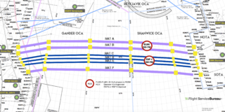
- 1 2 "International OPS Notice No. 11/2015" (PDF). Flight Service Bureau. 12 November 2015. Archived from the original (PDF) on 22 December 2015. Retrieved December 18, 2015.
- ↑ "More NAT half-tracks are coming". International Ops 2018. 2017-12-22. Retrieved 2019-01-08.
- ↑ "NATS: Reduced Lateral Separation Minima". nats.aero.
- ↑ "Did you know MNPS is over? Meet HLA, the new North Atlantic Airspace". International Ops 2018. 2016-01-22. Retrieved 2019-01-08.
- ↑ "RLatSM". International Ops 2018. Retrieved 2019-01-08.