Related Research Articles

The United States Virgin Islands are a group of several dozen islands and cays located in the Caribbean, about 1,100 miles (1,770 km) southeast of Florida, 600 miles (966 km) north of Venezuela, 40 miles (64 km) east of Puerto Rico, and immediately west and south of the British Virgin Islands.

Saint Croix is an island in the Caribbean Sea, and a county and constituent district of the United States Virgin Islands (USVI), an unincorporated territory of the United States.

The Virgin Islands National Park is an American national park preserving about 60% of the land area of Saint John in the United States Virgin Islands, as well as more than 5,500 acres of adjacent ocean, and nearly all of Hassel Island, just off the Charlotte Amalie, Saint Thomas harbor.

Buck Island Reef National Monument, or just Buck Island is a small, uninhabited, 176 acre island about 1.5 miles (2.4 km) north of the northeast coast of Saint Croix, U.S. Virgin Islands. The monument also includes 18,839 acres of submerged lands totaling 19,015 acres. It was first established as a protected area by the U.S. Government in 1948, with the intention of preserving “one of the finest marine gardens in the Caribbean Sea.” The U.S. National Monument was created in 1961 by John F. Kennedy and greatly expanded in 2001 by Bill Clinton, over the bitter opposition of local fishermen. Buck Island National Monument is one of few places in the Virgin Islands where brown pelicans and threatened least terns nest.

Saint John is one of the Virgin Islands in the Caribbean Sea and a constituent district of the United States Virgin Islands (USVI), an unincorporated territory of the United States.

Cruz Bay, U.S. Virgin Islands is the main town on the island of Saint John in the United States Virgin Islands. According to the 2000 census, Cruz Bay had a population of 2,743.
Trunk Bay is a body of water and a beach on St. John in the United States Virgin Islands. Trunk Bay is part of the Virgin Islands National Park. Trunk Bay is named for the Leatherback turtle, which is endemic to the U.S.V.I. and is locally known as trunks. The beach area is divided into two halves, the main Trunk Bay beach and swim area and Burgesman Cove which is located on the west end of Trunk Bay near Jumby Bay. Its amenities include a snack bar, showers and restrooms, a lifeguard, and an underwater trail for snorkeling its coral reef. Trunk Bay has consistently been voted one of the top beaches in the world.

Cinnamon Bay is a body of water and a beach on St. John island, within Virgin Islands National Park, in the United States Virgin Islands.
Waterlemon Cay is a small cay surrounded by a fringing reef located in Leinster Bay on Saint John, U.S. Virgin Islands. It is named after the water lemon.
Concordia is an area on the island of Saint John in the United States Virgin Islands. It is located on the south east corner of the island, near Salt Pond Bay. Much of the area is part of Virgin Islands National Park. Concordia Eco-Resort is located here.
Fish Bay is a bay and neighborhood on the island of Saint John in the United States Virgin Islands. Most of this area is part of Virgin Islands National Park.
Hermitage is an area of Virgin Islands National Park on the island of Saint John in the United States Virgin Islands. It is located along the north side of Coral Bay, between the town of Coral Bay and the island's inhabited East End. The mangroves of Princess Bay, inside the National Park, are a popular kayaking and snorkeling spot.
L'Esperance is a former plantation on the island of Saint John in the United States Virgin Islands. It is uninhabited and part of Virgin Islands National Park. The L'Esperance trail is maintained by the National Park Service.
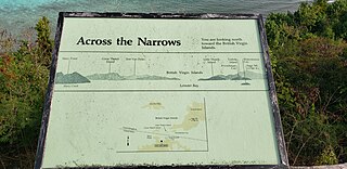
Leinster Bay is a bay and former sugar cane plantation on the island of Saint John in the United States Virgin Islands. It is uninhabited and part of Virgin Islands National Park. Visitors can park at Annaberg and hike the Leinster Bay trail to access the bay, which is a popular snorkeling spot. Waterlemon Cay is a small cay in Leinster Bay. The ruins of the plantation's estate house can be reached by continuing past the bay and up the Johnny Horn Trail.
Mary Point is an uninhabited peninsula on the island of Saint John in the United States Virgin Islands. There are no roads or trails and steep cliffs prevent access from the water. Although Mary Point once housed a small sugar cane plantation, the area is now overgrown with thick forest. The foundation and crumbling walls of Mary Point Estate can be seen from the Francis Bay trail. It is part of Virgin Islands National Park. Mary Creek, the shallow bay on the east side, is a popular spot for fly fishing and kitesurfing.
Mollendal is an uninhabited part of Virgin Islands National Park on the island of Saint John in the United States Virgin Islands. The L'Esperance Trail passes through this area.
Mount Pleasant is an area of Virgin Islands National Park on the island of Saint John in the United States Virgin Islands. It is located between Maho Bay and Centerline Road. This area is uninhabited and its name has fallen out of use.
Sieben is a former plantation on the island of Saint John in the United States Virgin Islands. Homes in this area are considered by the local government to be located in Remainder Fish Bay. The Sieben plantation ruins are accessible via the L'Esperance Trail. Most of this area is part of Virgin Islands National Park. The only baobab tree on St. John is near the Sieben ruins.

The Creque Marine Railway, formerly the "St Thomas Marine Repair Facility", is an inclined-plane ship railway on Hassel Island, in the bay of Charlotte Amalie off the coast of St. Thomas Island, in the U.S. Virgin Islands. Its site is below Fort Shipley, within Virgin Islands National Park.
References
Coordinates: 18°19′46″N64°44′16″W / 18.32944°N 64.73778°W
| This Saint John, United States Virgin Islands location article is a stub. You can help Wikipedia by expanding it. |