
Seismology is the scientific study of earthquakes and the generation and propagation of elastic waves through the Earth or other planetary bodies. It also includes studies of earthquake environmental effects such as tsunamis as well as diverse seismic sources such as volcanic, tectonic, glacial, fluvial, oceanic microseism, atmospheric, and artificial processes such as explosions and human activities. A related field that uses geology to infer information regarding past earthquakes is paleoseismology. A recording of Earth motion as a function of time, created by a seismograph is called a seismogram. A seismologist is a scientist works in basic or applied seismology.

A seismic wave is a mechanical wave of acoustic energy that travels through the Earth or another planetary body. It can result from an earthquake, volcanic eruption, magma movement, a large landslide and a large man-made explosion that produces low-frequency acoustic energy. Seismic waves are studied by seismologists, who record the waves using seismometers, hydrophones, or accelerometers. Seismic waves are distinguished from seismic noise, which is persistent low-amplitude vibration arising from a variety of natural and anthropogenic sources.

A seismometer is an instrument that responds to ground noises and shaking such as caused by quakes, volcanic eruptions, and explosions. They are usually combined with a timing device and a recording device to form a seismograph. The output of such a device—formerly recorded on paper or film, now recorded and processed digitally—is a seismogram. Such data is used to locate and characterize earthquakes, and to study the internal structure of Earth.
Seismic tomography or seismotomography is a technique for imaging the subsurface of the Earth with seismic waves produced by earthquakes or explosions. P-, S-, and surface waves can be used for tomographic models of different resolutions based on seismic wavelength, wave source distance, and the seismograph array coverage. The data received at seismometers are used to solve an inverse problem, wherein the locations of reflection and refraction of the wave paths are determined. This solution can be used to create 3D images of velocity anomalies which may be interpreted as structural, thermal, or compositional variations. Geoscientists use these images to better understand core, mantle, and plate tectonic processes.

Reflection seismology is a method of exploration geophysics that uses the principles of seismology to estimate the properties of the Earth's subsurface from reflected seismic waves. The method requires a controlled seismic source of energy, such as dynamite or Tovex blast, a specialized air gun or a seismic vibrator. Reflection seismology is similar to sonar and echolocation.
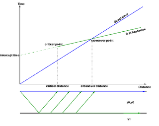
Seismic refraction is a geophysical principle governed by Snell's Law of refraction. The seismic refraction method utilizes the refraction of seismic waves by rock or soil layers to characterize the subsurface geologic conditions and geologic structure.
A geophone is a device that converts ground movement (velocity) into voltage, which may be recorded at a recording station. The deviation of this measured voltage from the base line is called the seismic response and is analyzed for structure of the Earth.
Exploration geophysics is an applied branch of geophysics and economic geology, which uses physical methods at the surface of the Earth, such as seismic, gravitational, magnetic, electrical and electromagnetic, to measure the physical properties of the subsurface, along with the anomalies in those properties. It is most often used to detect or infer the presence and position of economically useful geological deposits, such as ore minerals; fossil fuels and other hydrocarbons; geothermal reservoirs; and groundwater reservoirs. It can also be used to detect the presence of unexploded ordnance.

A seismic source is a device that generates controlled seismic energy used to perform both reflection and refraction seismic surveys. A seismic source can be simple, such as dynamite, or it can use more sophisticated technology, such as a specialized air gun. Seismic sources can provide single pulses or continuous sweeps of energy, generating seismic waves, which travel through a medium such as water or layers of rocks. Some of the waves then reflect and refract and are recorded by receivers, such as geophones or hydrophones.

Geophysical imaging is a minimally destructive geophysical technique that investigates the subsurface of a terrestrial planet. Geophysical imaging is a noninvasive imaging technique with a high parametrical and spatio-temporal resolution. It can be used to model a surface or object understudy in 2D or 3D as well as monitor changes.
In acoustics, microbaroms, also known as the "voice of the sea", are a class of atmospheric infrasonic waves generated in marine storms by a non-linear interaction of ocean surface waves with the atmosphere. They typically have narrow-band, nearly sinusoidal waveforms with amplitudes up to a few microbars, and wave periods near 5 seconds. Due to low atmospheric absorption at these low frequencies, microbaroms can propagate thousands of kilometers in the atmosphere, and can be readily detected by widely separated instruments on the Earth's surface.
Microtremor is a low amplitude ambient vibration of the ground caused by man-made or atmospheric disturbances. The term Ambient Vibrations is now preferred to talk about this phenomenon. Observation of microtremors can give useful information on dynamic properties of the site such as predominant period and amplitude. Microtremor observations are easy to perform, inexpensive and can be applied to places with low seismicity as well, hence, microtremor measurements can be used conveniently for seismic microzonation. More detailed information on the shear wave velocity profile of the site can be obtained from microtremor array observation.
The seismoelectrical method is based on the generation of electromagnetic fields in soils and rocks by seismic waves. This technique is still under development and in the future it may have applications like detecting and characterizing fluids in the underground by their electrical properties, among others, usually related to fluids.
In seismology, a microseism is defined as a faint earth tremor caused by natural phenomena. Sometimes referred to as a "hum", it should not be confused with the anomalous acoustic phenomenon of the same name. The term is most commonly used to refer to the dominant background seismic and electromagnetic noise signals on Earth, which are caused by water waves in the oceans and lakes. Characteristics of microseism are discussed by Bhatt. Because the ocean wave oscillations are statistically homogenous over several hours, the microseism signal is a long-continuing oscillation of the ground. The most energetic seismic waves that make up the microseismic field are Rayleigh waves, but Love waves can make up a significant fraction of the wave field, and body waves are also easily detected with arrays. Because the conversion from the ocean waves to the seismic waves is very weak, the amplitude of ground motions associated to microseisms does not generally exceed 10 micrometers.
Rayleigh waves are a type of surface acoustic wave that travel along the surface of solids. They can be produced in materials in many ways, such as by a localized impact or by piezo-electric transduction, and are frequently used in non-destructive testing for detecting defects. Rayleigh waves are part of the seismic waves that are produced on the Earth by earthquakes. When guided in layers they are referred to as Lamb waves, Rayleigh–Lamb waves, or generalized Rayleigh waves.
In geophysics, geology, civil engineering, and related disciplines, seismic noise is a generic name for a relatively persistent vibration of the ground, due to a multitude of causes, that is often a non-interpretable or unwanted component of signals recorded by seismometers.

Interferometry examines the general interference phenomena between pairs of signals in order to gain useful information about the subsurface. Seismic interferometry (SI) utilizes the crosscorrelation of signal pairs to reconstruct the impulse response of a given media. Papers by Keiiti Aki (1957), Géza Kunetz, and Jon Claerbout (1968) helped develop the technique for seismic applications and provided the framework upon which modern theory is based.

Seismic inversion involves the set of methods which seismologists use to infer properties through physical measurements. Surface-wave inversion is the method by which elastic properties, density, and thickness of layers in the subsurface are obtained through analysis of surface-wave dispersion. The entire inversion process requires the gathering of seismic data, the creation of dispersion curves, and finally the inference of subsurface properties.
Seismic data acquisition is the first of the three distinct stages of seismic exploration, the other two being seismic data processing and seismic interpretation. Seismic acquisition requires the use of a seismic source at specified locations for a seismic survey, and the energy that travels within the subsurface as seismic waves generated by the source gets recorded at specified locations on the surface by what is known as receivers.
Subsurface mapping by ambient noise tomography is the mapping underground geological structures under the assistance of seismic signals. Ambient noise, which is not associated with the earthquake, is the background seismic signals. Given that the ambient noises have low frequencies in general, the further classification of ambient noise include secondary microseisms, primary microseisms, and seismic hum, based on different range of frequencies. We can utilize the ambient noise data collected by seismometers to create images for the subsurface under the following processes. Since the ambient noise is considered as diffuse wavefield, we can correlate the filtered ambient noise data from a pair of seismic stations to find the velocities of seismic wavefields. A 2-dimensional or 3-dimensional velocity map, showing the spatial velocity difference of the subsurface, can thus be created for observing the geological structures. Subsurface mapping by ambient noise tomography can be applied in different fields, such as detecting the underground void space, monitoring landslides, and mapping the crustal and upper mantle structure.