
King's Cross is a district on either side of Euston Road, in north London, England, 1.5 miles (2.4 km) north of Charing Cross. It is bordered by Barnsbury to the north, Clerkenwell and Islington to the east, Holborn to the south and Euston to the west. It is served by two major rail termini, St Pancras and King's Cross. King's Cross station is the terminus of one of the major rail routes between London and the North.

Sir Antony Mark David Gormley is a British sculptor. His works include the Angel of the North, a public sculpture in Gateshead in the north of England, commissioned in 1994 and erected in February 1998; Another Place on Crosby Beach near Liverpool; and Event Horizon, a multipart site installation which premiered in London in 2007, then subsequently in Madison Square in New York City (2010), São Paulo, Brazil (2012), and Hong Kong (2015–16).

Euston Road is a road in Central London that runs from Marylebone Road to King's Cross. The route is part of the London Inner Ring Road and forms part of the London congestion charge zone boundary. It is named after Euston Hall, the family seat of the Dukes of Grafton, who had become major property owners in the area during the mid-19th century.

Paddington Basin is the name given to a long canal basin, and its surrounding area, in Paddington, London.

Wood Wharf is a 23 acre site in Canary Wharf, London. It is currently under construction to provide offices, residential homes and retail space. The site is next to Canary Wharf. Wood Wharf will contain 5 million square feet of space, which will include 2 million sq ft of office space, 3,330 residential homes, 3.6 hectares of public spaces, and 380,000 sq ft of shops, restaurants and space for community use. It is estimated to be completed in 2023.

Chater House is an office tower in Central, Hong Kong. Opened in March 2003, it is a part of the Hongkong Land portfolio of properties. It has a three-level retail podium, known as Landmark Chater. The building was built on the site of the former Swire House, and was named after Sir Paul Chater. The building faces streets on three sides: Chater Road, Pedder Street and Connaught Road Central.

The Big City Plan is a major development plan for the city centre of Birmingham, England.

Scotia Square is a commercial development in downtown Halifax, Nova Scotia, Canada. It was built from the late 1960s to late 1970s and is managed by Crombie REIT.

CityPlace is a neighbourhood in Downtown Toronto, Ontario, Canada, within the former Railway Lands. When completed, this area will be the largest residential development ever created in Toronto. The area is bordered by Bathurst Street to the west, Lake Shore Boulevard to the south, and Front Street to the north and Blue Jays Way and Rogers Centre to the east. Cityplace is also a five-to-ten-minute walk from King Street West and Liberty Village and a ten-to-twenty-minute walk from Toronto's financial district. The neighbourhood is also home to the Canoe Landing Park, designed by famed Canadian writer and artist Douglas Coupland.
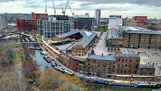
King's Cross Central (KXC) is a mixed-use development in the north-east of central London. The site is owned and controlled by the King's Cross Central Limited Partnership. It consists of approximately 67 acres (27 ha) of former railway lands to the north of King's Cross and St Pancras mainline railway stations. The site is largely determined by three boundaries: the existing East Coast Main Line railway leading out of King's Cross; York Way, a road marking the division between Camden and Islington boroughs; and the new railway line, High Speed 1 (HS1), formerly known as the Channel Tunnel Rail Link, which curves around the site to the north and west.

Paddington Waterside is a developed area around Paddington Station in London.
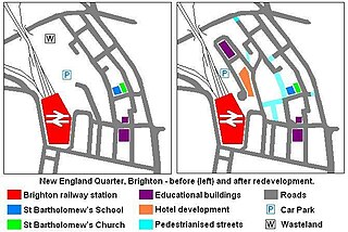
The New England Quarter is a mixed-use development in the city of Brighton and Hove, England. It was built between 2004 and 2008 on the largest brownfield site in the city, adjacent to Brighton railway station. Most parts of the scheme have been finished, but other sections are still being built and one major aspect of the original plan was refused planning permission.
St Martins Property Investments Limited is a property development, investment and asset management company based in the United Kingdom representing the real estate interests of the State of Kuwait with their headquarters in London Bridge City, London. The company is wholly owned by the Kuwait sovereign wealth fund, Future Generations Fund.

Regent's Park Estate is a large housing estate in the London Borough of Camden. The estate consists of nearly 2,000 homes across 49 buildings and lies on either side of Robert Street, between Albany Street and Hampstead Road. It is immediately to the east of the Regent's Park estate owned by the Crown Estate. The estate includes the sites of Cumberland Market, Munster Square and Clarence Gardens.

The London Borough of Croydon has a wide variety of buildings mainly from post-war through to modern. Much of the modern architecture in the borough is centred on the commercial centre of the town, with much of the Victorian designs spread out on both the northern and southern corridors of the borough. Many former warehouses and factories have been converted for other uses changing the external appearance of Croydon erratically.
The following is a non-exhaustive list of private housing estates in Sha Tin District, Hong Kong.

Bolsover Street is in the Parish of St Marylebone in London's West End. In administrative terms it lies within the City of Westminster's Marylebone High Street Ward and is partly in the Harley Street Conservation Area whilst also sitting on the edges of the Regents Park and East Marylebone Conservation Areas.

The Hayward Gallery is an art gallery within the Southbank Centre in central London, England and part of an area of major arts venues on the South Bank of the River Thames. It is sited adjacent to the other Southbank Centre buildings and also the National Theatre and BFI Southbank repertory cinema. Following a rebranding of the South Bank Centre to Southbank Centre in early 2007, the Hayward Gallery was known as the Hayward until early 2011.
This is a list of the etymology of street names in the area of Regent's Park in London ; the area has no formal boundaries, though it generally thought to be delimited by Prince Albert Road to the north, Park Village East and Hampstead Road/the Euston railway line/Eversholt Street to the east, Euston Road and Marylebone Road to the south and Park Road and Baker Street to the west.


