
The United States Numbered Highway System is an integrated network of roads and highways numbered within a nationwide grid in the contiguous United States. As the designation and numbering of these highways were coordinated among the states, they are sometimes called Federal Highways, but the roadways were built and have always been maintained by state or local governments since their initial designation in 1926.
The New Zealand state highway network is the major national highway network in New Zealand. Nearly 100 roads in the North and South Islands are state highways. All state highways are administered by the NZ Transport Agency.
A state highway, state road, or state route is usually a road that is either numbered or maintained by a sub-national state or province. A road numbered by a state or province falls below numbered national highways in the hierarchy. Roads maintained by a state or province include both nationally numbered highways and un-numbered state highways. Depending on the state, "state highway" may be used for one meaning and "state road" or "state route" for the other.

The National Cycle Network (NCN) is the national cycling route network of the United Kingdom, which was established to encourage cycling throughout Britain, as well as for the purposes of bicycle touring. It was created by the charity Sustrans who were aided by a £42.5 million National Lottery grant. In 2017, the 16,575 mile network was used for over 786 million trips.

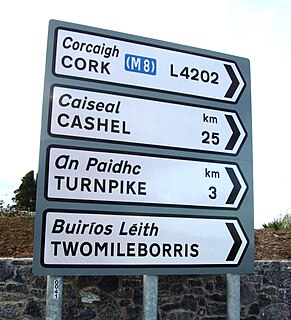
The island of Ireland, comprising Northern Ireland and the Republic of Ireland, has an extensive network of tens of thousands of kilometres of public roads, usually surfaced. These roads have been developed and modernised over centuries, from trackways suitable only for walkers and horses, to surfaced roads including modern motorways. The major routes were established before Irish independence and consequently take little cognisance of the border other than a change of identification number and street furniture. Northern Ireland has had motorways since 1962, and has a well-developed network of primary, secondary and local routes. The Republic started work on its motorway network in the early 1980s; and historically, the road network there was once somewhat less well developed. However, the Celtic Tiger economic boom and an influx of European Union structural funding, saw national roads and regional roads in the Republic come up to international standard quite quickly. In the mid-1990s, for example, the Republic went from having only a few short sections of motorway to a network of motorways, dual carriageways and other improvements on most major routes as part of a National Development Plan. Road construction in Northern Ireland now tends to proceed at a slower pace than in the Republic, although a number of important bypasses and upgrades to dual carriageway have recently been completed or are about to begin.

Highways in Australia are generally high capacity roads managed by state and territory government agencies, though Australia's federal government contributes funding for important links between capital cities and major regional centres. Prior to European settlement, the earliest needs for trade and travel were met by narrow bush tracks, used by tribes of Indigenous Australians. The formal construction of roads began in 1788, after the founding of the colony of New South Wales, and a network of three major roads across the colony emerged by the 1820s. Similar road networks were established in the other colonies of Australia. Road construction programs in the early 19th century were generally underfunded, as they were dependent on government budgets, loans, and tolls; while there was a huge increase in road usage, due to the Australian gold rushes. Local government authorities, often known as Road Boards, were therefore established to be primarily responsible for funding and undertaking road construction and maintenance. The early 1900s saw both the increasingly widespread use of motorised transportation, and the creation of state road authorities in each state, between 1913 and 1926. These authorities managed each state's road network, with the main arterial roads controlled and maintained by the state, and other roads remaining the responsibility of local governments. The federal government became involved in road funding in the 1920s, distributing funding to the states. The depression of the 1930s slowed the funding and development of the major road network until the onset on World War II. Supply roads leading to the north of the country were considered vital, resulting in the construction of Barkly, Stuart, and Eyre Highways.

A trunk road, trunk highway, or strategic road is a major road, usually connecting two or more cities, ports, airports and other places, which is the recommended route for long-distance and freight traffic. Many trunk roads have segregated lanes in a dual carriageway, or are of motorway standard.

RTA Rapid Transit is a rapid transit, light rail, and bus rapid transit system in Cleveland and surrounding areas in Cuyahoga County. The system is owned and operated by the Greater Cleveland Regional Transit Authority (GCRTA), and currently consists of 7 service lines.
A route number is an identifying numeric designation assigned by a highway authority to a particular stretch of roadway to distinguish it from other routes and, in many cases, also to indicate its classification, general geographical location and/or orientation. The numbers chosen may be used solely for internal administrative purposes; however, in most cases they are also displayed on roadside signage and indicated on maps.

A county highway is a road in the United States and in the Canadian province of Ontario that is designated and/or maintained by the county highway department. Route numbering can be determined by each county alone, by mutual agreement among counties, or by a statewide pattern.
Regional routes are the third category of road in the South African route numbering scheme. They are designated with the letter "R" followed by a three-digit number. They serve as feeders connecting smaller towns to the national and provincial routes. Designation as a regional road does not necessarily imply any particular size of road; they range from gravel roads to multi-lane freeways.

A national secondary road is a category of road in Ireland. These roads form an important part of the national route network, but are secondary to the main arterial routes which are classified as national primary roads. National secondary roads are designated with route numbers higher than those used for primary roads, but with the same "N" prefix. Routes N51 and higher are all national secondary roads.
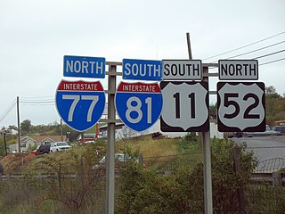
A highway shield or route marker is a sign denoting the route number of a highway, usually in the form of a symbolic shape with the route number enclosed. As the focus of the sign, the route number is usually the sign's largest element, with other items on the sign rendered in smaller sizes or contrasting colors. Highway shields are used by travellers, commuters, and all levels of government for identifying, navigating, and organising routes within a county, state, province, or country. Simplified highway shields often appear on maps.

A national primary road is a road classification in Ireland. National primary roads form the major routes between the major urban centres. There are 2649 km of national primary roads. This category of road has the prefix "N" followed by one or two digits. Motorways are prefixed "M" followed by one or two digits.
The North Carolina Highway System consists of a vast network of Interstate, United States, and state highways, managed by the North Carolina Department of Transportation. North Carolina has the second largest state maintained highway network in the United States because all roads in North Carolina are maintained by either municipalities or the state. Since counties do not maintain roads, there is no such thing as a "county road" within the state.
A local road in the Ireland is a public road not classified as a national primary road, national secondary road, or regional road but nevertheless forming a link in the national network of roads. Local roads are numbered with four- or five-digit route numbers, prefixed by "L".
In South Africa some roads are designated as numbered routes to help with navigation. There is a nationwide numbering scheme consisting of national, provincial and regional routes, and within various urban areas there are schemes of metropolitan route numbering.
The Philippine highway network refers to the highway system of the Philippines. It is a network of national roads owned and maintained by the Department of Public Works and Highways which are organized into three classifications depending on their function or purpose they serve within the road network: national primary, national secondary, and national tertiary roads. The national roads connecting major cities are numbered N1–N82. They are mostly single and dual carriageways linking two or more cities.

The réseau routier québécois is managed by the Société de l'assurance automobile du Québec (SAAQ) and consists of about 185,000 kilometres of highways and roads. In addition, Quebec has almost 12,000 bridges, tunnels, retaining walls, culverts, and other structures such as the Quebec Bridge, the Laviolette Bridge and the Louis-Hippolyte Lafontaine Bridge–Tunnel.

