
The Rhine is one of the major European rivers. The river begins in the Swiss canton of Graubünden in the southeastern Swiss Alps. It forms the Swiss-Liechtenstein border and partly the Swiss-Austrian and Swiss-German borders. After that the Rhine defines much of the Franco-German border, after which it flows in a mostly northerly direction through the German Rhineland. Finally in Germany, the Rhine turns into a predominantly westerly direction and flows into the Netherlands where it eventually empties into the North Sea. It drains an area of 9,973 km2.

The Albula Pass is a Swiss mountain pass in the canton of Graubünden. It lies at the heart of the Albula Alps, on the watershed between the Albula, tributary of the Rhine and the Ova d'Alvra, tributary of the Inn. Overlooking the pass are the ranges of Piz Üertsch (north) and Crasta Mora (south).

The Vorderrhein, or Anterior Rhine, is the left of the two initial tributaries of the Rhine. It is longer than the Hinterrhein, but has a lower discharge than the latter at their confluence, which marks the beginning of the Alpine Rhine section.

Lai da Sontga Maria is a lake, located north of the Lukmanier Pass in Switzerland. It lies almost entirely in the municipality of Medel, a tiny fraction of the south-west part of the lake belonging to the municipalities of Quinto and Blenio. The reservoir has a surface area is 1.77 km2 (0.68 sq mi). The arch dam Santa Maria, which is to the north of the lake, was completed in 1968. The main road of the Lukmanier Pass runs along the eastern shore of the lake.

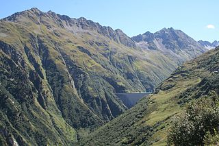
Lai da Nalps is a reservoir in the municipality of Tujetsch, Grisons, Switzerland. It has a capacity of 45 million m³ and a surface area of 0.91 km². The reservoir is connected to Lai da Sontga Maria and Lai da Curnera in neighboring valleys.

Lai da Curnera is a reservoir on the river Rein da Curnera in the municipality of Tujetsch, in the Grisons, Switzerland. The reservoir is linked to Lai da Sontga Maria and Lai da Nalps in the neighboring valley. The lake's volume is 41.1 million cubic metres (33,300 acre⋅ft) and its surface area 81 ha.

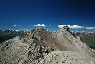
Piz Blas is a mountain in the Lepontine Alps, located on the border between the cantons of Graubünden and Ticino. At 3,019 metres above sea level, Piz Blas is the highest mountain of Val Cadlimo (Ticino), a valley drained by the Reno da Medel, a tributary of the Rhine. On its northern side (Graubünden), it overlooks the valleys of Lake Curnera and Lake Nalps, both drained by tributaries of the Rhine.
Piz Lischana is a mountain in the Sesvenna Range of the Alps, overlooking Scuol in the Swiss canton of Graubünden. With an elevation of 3,105 metres above sea level, Piz Lischana is the highest summit of the Sesvenna Range north of the Fuorcla Sesvenna.
Piz Maler is a mountain of the Swiss Lepontine Alps, located south of Sedrun in the canton of Graubünden. It lies at the northern end of the range between Lai da Curnera and Lai da Nalps.

Lake Toma in the Swiss canton of Grisons is generally regarded as the Source of the River Rhine. The lake's outflow, the Rein da Tuma, subsequently becomes the Anterior Rhine, which later confluences with the Posterior Rhine to form the Rhine. Because the tributary systems of the Rhine differ only slightly in length, discharge and the size of their drainage areas, it is difficult to pinpoint a single source of this major European river.

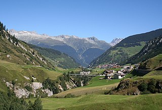
The Rein da Tuma is a river in Switzerland, in the Canton of Graubünden. It rises east of the Rossbodenstock with two or three mountain streams, that flow across the Tuma Alp into the Lake Toma. Before reaching the lake, it flows through a plain and forms small meanders. The Rein da Tuma flows out of Lake Toma on the north east and flows as Anterior Rhine past the village of Tschamut in the municipality of Tujetsch.

The Rein da Medel is the longest headwater of the Rhine. It is located in the Swiss cantons of Ticino and Graubünden and flows through the valleys Val Cadlimo and Val Medel. Rein da Medel is the local Sursilvan, name in Graubünden, which is commonly used to denote the ticinese part as well.

The Rein da Curnera is a right tributary of the Anterior Rhine and one of the main tributaries of the Rhine. It is fed from multiple sources and glaciers at the southern end of the valley. The river is about 8 kilometres (5 mi) long and flows north through the Val Curnera. Approximately in the middle of its route, a dam was constructed by Kraftwerke Vorderrhein AG, which formed Lai da Curnera. At this point, the Rein da Curnera takes up a left tributary, the Rein da Maighels.

The Dischmabach is a river of approximately 15 km long in the river system of Albula. It drains the Dischma valley, its catchment area lies mainly in the area of the Swiss municipality of Davos.
The Val Medel is a righthand side valley of the Surselva valley in Graubünden, Switzerland. It is approximately 15 km (9.3 mi) long and stretches from Disentis to the south, where it ends at Lai da Sontga Maria reservoir on Lukmanier Pass. There is a road through the valley and over Lukmanier Pass into Ticino.

The Valser Rhine is a source of the river Rhine in the Swiss canton of Graubünden. The river originates from the Länta Glacier and the Grauhorn Glacier at the northern foot of the Rheinwaldhorn and initially flows through the valley Länta before it flows into the Zervreilasee reservoir. Before the construction of the reservoir, the brooks Hornbach and Canalbach would flow into Valser Rhine from the right at the village of Zervreila. Today, the brooks flow into the reservoir, as does the Finsterbach, also from the right.
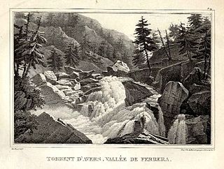
The Avers Rhine is a tributary of the Hinterrhein/Rein Posteriur in the Swiss canton of Graubünden.
Piz Denter is a mountain of the Lepontine Alps, located on the border between the Swiss cantons of Graubünden and Ticino. On its northern side (Graubünden), it overlooks the valleys of Lake Curnera and Lake Nalps, both drained by tributaries of the Rhine.

The Val Roseg is a valley of the Swiss Alps, located on the north side of the Bernina Range in the canton of Graubünden (Engadin). The valley is drained by the Ova da Roseg, a tributary of the Flaz, at Pontresina. Most of the valley is part of an exclave of the municipality of Samedan. Only the bottom of Val Roseg lies in the municipality of Pontresina.
The following is a list of Romansh exonyms, that is to say Romansh-language names for towns and cities that do not speak Romansh.

