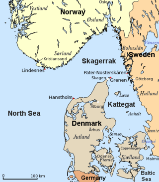
The Kattegat is a 30,000 km2 (12,000 sq mi) sea area bounded by the Jutlandic peninsula in the west, the Danish straits islands of Denmark and the Baltic Sea to the south and the provinces of Bohuslän, Västergötland, Halland and Skåne in Sweden in the east. The Baltic Sea drains into the Kattegat through the Danish straits. The sea area is a continuation of the Skagerrak and may be seen as a bay of the North Sea and North Atlantic Ocean, but in traditional Scandinavian usage, this is not the case.

The Arctic Archipelago, also known as the Canadian Arctic Archipelago, is an archipelago lying to the north of the Canadian continental mainland, excluding Greenland and Iceland.

The Celebes Sea or Sulawesi Sea of the western Pacific Ocean is bordered on the north by the Sulu Archipelago and Sulu Sea and Mindanao Island of the Philippines, on the east by the Sangihe Islands chain, on the south by Sulawesi's Minahasa Peninsula, and the west by northern Kalimantan in Indonesia. It extends 420 miles (675 km) north-south by 520 mi (840 km) east-west and has a total surface area of 110,000 square miles (280,000 km2), to a maximum depth of 20,300 feet (6,200 m). South of the Cape Mangkalihat, the sea opens southwest through the Makassar Strait into the Java Sea.
This is a list of the extreme points of the United Kingdom: the points that are farther north, south, east or west than any other location. Traditionally the extent of the island of Great Britain has stretched "from Land's End to John o' Groats".

This is a list of the extreme points of Ireland – the points that are furthest north, south, east or west in Ireland. It includes the Republic of Ireland and Northern Ireland.

The arrondissement of Cahors is an arrondissement of France in the Lot department in the Occitanie région. It has 98 communes. Its population is 71,943 (2016), and its area is 1,860.9 km2 (718.5 sq mi).
Gorlitz is a hamlet in southeastern Saskatchewan. It is located approximately 27 kilometres (17 mi) north of Yorkton, Saskatchewan and approximately 20 kilometres (12 mi) south of Canora. The hamlet was named after Görlitz in Saxony, Germany by Karl Gebek, a German settler.
Baribour is a district (srok) in the north of Kampong Chhnang province, in central Cambodia. The district capital is Baribour town located around 38 kilometres north west of the provincial capital of Kampong Chhnang by road. The district shares a border with Pursat province to the west and with Kampong Thom province to the north. The district borders on the Tonlé Sap and the Tonlé Sap River forms the northern and eastern borders of the district.

Santa María del Invierno is a municipality and town located in the province of Burgos, Castile and León, Spain. According to the 2004 census (INE), the municipality has a population of 69 inhabitants.

Rábano de Aliste is a municipality located in the province of Zamora, Castile and León, Spain. According to the 2004 census (INE), the municipality has a population of 450 inhabitants.

San Miguel del Arroyo is a municipality located in the province of Valladolid, Castile and León, Spain. According to the 2004 census (INE), the municipality has a population of 785 inhabitants.

Ghardimaou is a town in the north-west of Tunisia about 192 km from Tunis. It belongs to the Jendouba Governorate. The town has about 19,574 inhabitants. The rail line from Tunis passing along the Medjerda river ends at Ghardimou; it was built in 1878, and formerly crossed westwards the border into Algeria. Souk Ahras, the first stop in Algeria, is 16 km away.
Abish-Kyand is a village in the Bilasuvar Rayon of Azerbaijan.

Bluie was the United States military code name for Greenland during World War II. It is remembered by the numbered sequence of base locations identified by the 1941 United States Coast Guard South Greenland Survey Expedition, and subsequently used in radio communications by airmen unfamiliar with pronunciation of the Greenlandic Inuit and Danish names of those locations. These were typically spoken BLUIE (direction) (number), with direction being east or west along the Greenland coast from Cape Farewell.
The Porthos Range is the second range south in the Prince Charles Mountains of Antarctica, extending for about 30 miles in an east-to-west direction between Scylla Glacier and Charybdis Glacier. First visited in December 1956 by the Australian National Antarctic Research Expeditions (ANARE) southern party under W.G. Bewsher (1956-57) and named after Porthos, a character in Alexandre Dumas, père's novel The Three Musketeers, the most popular book read on the southern journey.

Katuntsi is a village in the municipality of Sandanski, in Blagoevgrad Province, Bulgaria.

Bresnica is a village in the municipality of Bosilegrad, Serbia. According to the 2002 census, the town has a population of 77 people.
Parthenina interstincta is a rather widely distributed species of sea snail, a marine gastropod mollusk in the family Pyramidellidae, the pyrams and their allies.