The Fulda District is a Kreis (district) in the north-east of Hesse, Germany. Neighboring districts are Hersfeld-Rotenburg, Wartburgkreis, Schmalkalden-Meiningen, Rhön-Grabfeld, Bad Kissingen, Main-Kinzig, Vogelsbergkreis.
Hildburghausen is a district in Thuringia, Germany. It is bounded by the district of Schmalkalden-Meiningen, the city of Suhl, the districts of Ilm-Kreis, Saalfeld-Rudolstadt and Sonneberg, and the state of Bavaria. Located roughly halfway between the mountain chains of the Rhön and the Thuringian Forest, the district is densely forested and covered by hilly countryside. Its territory is similar to that of the former Ernestine duchy, Saxe-Hildburghausen.
Schmalkalden-Meiningen is a Landkreis in the southwest of Thuringia, Germany. Its neighboring districts are the districts Wartburgkreis, Gotha, Ilm-Kreis, the district-free city Suhl, the district Hildburghausen, the Bavarian district Rhön-Grabfeld, and the district Fulda in Hesse.
Wartburgkreis is a Kreis (district) in the west of Thuringia, Germany. Neighboring districts are the districts Unstrut-Hainich-Kreis, Gotha, Schmalkalden-Meiningen, and the districts Fulda, Hersfeld-Rotenburg and Werra-Meißner-Kreis in Hesse. The district has 30 municipalities, including Eisenach.
Rhön-Grabfeld is a Landkreis (district) in Bavaria, Germany. It is bounded by the districts of Hassberge, Schweinfurt and Bad Kissingen, and the states of Hesse and Thuringia.

Kaltennordheim is a town in the Schmalkalden-Meiningen district, in Thuringia, Germany. It is situated in the Rhön Mountains, 22 km southwest of Bad Salzungen, and 35 km east of Fulda. The former municipalities Aschenhausen, Kaltensundheim, Kaltenwestheim, Melpers, Oberkatz und Unterweid were merged into Kaltennordheim in January 2019. At the same time, Kaltennordheim passed from the Wartburgkreis to Schmalkalden-Meiningen.

Mellrichstadt is a town in the district Rhön-Grabfeld, in Bavaria, Germany. It is situated 17 km southwest of Meiningen, and 13 km northeast of Bad Neustadt. It includes the following villages: Bahra, Eußenhausen, Frickenhausen, Mühlfeld, Sondheim im Grabfeld und Roßrieth.

Wasungen is a town in the Schmalkalden-Meiningen district, in Thuringia, Germany. It is situated on the river Werra, 11 km north of Meiningen. The former municipalities Hümpfershausen, Metzels, Oepfershausen, Unterkatz and Wahns were merged into Wasungen in January 2019.

Burkardroth is a municipality in the district of Bad Kissingen in Bavaria in Germany.
Jüchsen is a former municipality in the district Schmalkalden-Meiningen, in Thuringia, Germany. From 1 December 2007 it is part of Grabfeld.

Bauerbach is a village and a former municipality in the district of Schmalkalden-Meiningen, in Thuringia, Germany. Since 1 January 2012, it is part of the municipality Grabfeld.
Behrungen is a former municipality in the district Schmalkalden-Meiningen, in Thuringia, Germany. From December 1, 2007, it has been part of the Grabfeld district.
Berkach is a former municipality in the district Schmalkalden-Meiningen, in Thuringia, Germany. It has been a part of Grabfeld since December 1, 2007.
Queienfeld is a former municipality in the district Schmalkalden-Meiningen, in Thuringia, Germany. As of December 2007 it became part of Grabfeld.
Rentwertshausen is a former municipality in the district Schmalkalden-Meiningen, in Thuringia, Germany. From December 1, 2007, it is part of Grabfeld.
Schwickershausen is a former municipality in the district Schmalkalden-Meiningen, in Thuringia, Germany. From December 1, 2007, it is part of Grabfeld.
Sülzfeld is a village and a former municipality in the district Schmalkalden-Meiningen, in Thuringia, Germany. On 1 January 2024 it became part of the town Meiningen.
Wölfershausen is a village and a former municipality in the district Schmalkalden-Meiningen, in Thuringia, Germany. Since 1 January 2019, it is part of the municipality Grabfeld.
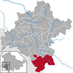
Schmalkalden-Meiningen I is an electoral constituency represented in the Landtag of Thuringia. It elects one member via first-past-the-post voting. Under the current constituency numbering system, it is designated as constituency 12. It covers the southern part of Schmalkalden-Meiningen.
Hildburghausen I – Schmalkalden-Meiningen III is an electoral constituency represented in the Landtag of Thuringia. It elects one member via first-past-the-post voting. Under the current constituency numbering system, it is designated as constituency 18. It covers the western part of Hildburghausen district and part of southern Schmalkalden-Meiningen.