
The Thuringian Forest is a mountain range in the southern parts of the German state of Thuringia, running northwest to southeast. Skirting from its southerly source in foothills to a gorge on its north-west side is the Werra valley. On the other side of the Forest is an upper outcrop of the North German Plain, the Thuringian Basin, which includes the city Erfurt. The south and south-east continuation of the range is the highland often called the Thuringian-Vogtlandian Slate Mountains.
Geisleden is a municipality in the district of Eichsfeld in Thuringia, Germany. It is located about 4 kilometres (2.5 mi) southeast of Heiligenstadt in the valley formed by the river Geislede. Other neighboring towns are Westhausen in the north, Kreuzebra to the east, and Heuthen toward the southeast.

Effelder is a municipality in the district of Eichsfeld in Thuringia, Germany. It is located in the center of the country.
Sonneberg in Thuringia, Germany, is the seat of the Sonneberg district. It is in the Franconian south of Thuringia, neighboring its Upper Franconian twin town Neustadt bei Coburg.
is a town situated in the forest of Thuringia in the district of Wartburgkreis in Germany, immediately next to the Rennsteig. Thal and Kittelsthal are parts of the town.
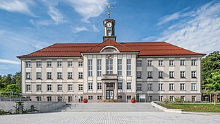
Oberhof is a town in the Schmalkalden-Meiningen district of Thuringia, Germany. Located in the Thuringian Forest mountain range, it is a winter sports center and health resort. With 1,625 inhabitants, it is visited by 144,000 tourists every year (2016). The town obtained its official city status in 1985.

Schmalkalden is a town in the Schmalkalden-Meiningen district, in the southwest of the state of Thuringia, Germany. It is on the southern slope of the Thuringian Forest at the Schmalkalde river, a tributary to the Werra. As of 31 December 2022, the town had a population of 20,065.

Willingen is a municipality in Waldeck-Frankenberg in northern Hesse, Germany, some 80 km west of Kassel.

Bad Salzungen is a town in Thuringia, Germany. It is the capital of the Wartburgkreis district.

Körle is a municipality in the Schwalm-Eder district in Hesse, Germany. It lies about 20 km south of Kassel near the turn-off for Guxhagen on Autobahn A 7.
Zella-Mehlis is a town in the Schmalkalden-Meiningen district, located in Thuringia, Germany. It is situated in the scenic Thuringian Forest, approximately 5 km north of Suhl and 20 km east of Meiningen. The town was notably home to Walther and Anschütz, two of Germany's most notable firearm manufacturers, both of which were originally founded in Zella-Mehlis. They operated there until Soviet occupation of Eastern Germany at the conclusion of World War II caused both companies to move.

Bürgel is a town in the Saale-Holzland district, in Thuringia, Germany. It is situated 12 km east of Jena. It contains the Benedictine monastery of Bürgel Abbey.

Ronneburg is a town in the district of Greiz, in Thuringia, Germany. It is situated 7 km east of Gera.

Tambach-Dietharz is a town in the district of Gotha, in Thuringia, Germany. It is situated in the Thuringian Forest, 19 km south of Gotha.

Kleinschmalkalden is a village on the southern slope of the Thuringian Forest in Landkreis Schmalkalden-Meiningen of Thuringia, Germany. In 2006 it joined the neighbouring municipality Floh-Seligenthal.

Ludwigsau is a municipality in Hersfeld-Rotenburg district in northeastern Hesse, Germany. With an area of 112 km² it is Hesse's biggest community by land area.

Albersdorf is a municipality in the Saale-Holzland district of Thuringia, Germany. As of 2018, the population is 288.
Kleinbockedra is a municipality in the district Saale-Holzland, in Thuringia, Germany. With 34 inhabitants at the end of 2019, it is the least populous municipality in what used to be East Germany, although there are 23 municipalities with lesser or equal population in what used to be West Germany. All of the Western municipalities are in either Rhineland-Palatinate (17), or Schleswig-Holstein (6).

Gerald Ullrich is a German electronics engineer and politician of the Free Democratic Party (FDP) who has been a member of the German Bundestag since 2017.
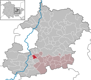
Schmalkalden-Meiningen II is an electoral constituency represented in the Landtag of Thuringia. It elects one member via first-past-the-post voting. Under the current constituency numbering system, it is designated as constituency 13. It covers the northern part of Schmalkalden-Meiningen.


