Related Research Articles

In urban planning, zoning is a method in which a municipality or other tier of government divides land into "zones", each of which has a set of regulations for new development that differs from other zones. Zones may be defined for a single use, they may combine several compatible activities by use, or in the case of form-based zoning, the differing regulations may govern the density, size and shape of allowed buildings whatever their use. The planning rules for each zone determine whether planning permission for a given development may be granted. Zoning may specify a variety of outright and conditional uses of land. It may indicate the size and dimensions of lots that land may be subdivided into, or the form and scale of buildings. These guidelines are set in order to guide urban growth and development.

Johnstone William "John" Thwaites is an Australian former politician, and served as Deputy Premier of the state of Victoria from 1999 to 2007.

Environmental planning is the process of facilitating decision making to carry out land development with the consideration given to the natural environment, social, political, economic and governance factors and provides a holistic framework to achieve sustainable outcomes. A major goal of environmental planning is to create sustainable communities, which aim to conserve and protect undeveloped land.
The Nationwide House Energy Rating Scheme (NatHERS) is an Australian scheme to measure the energy efficiency of a residential dwelling. An accredited software tool assesses the home based on a variety of criteria and produces an energy star rating.

Melbourne 2030 is a Victoria State Government strategic planning policy framework for the metropolitan area of Melbourne, Australia intended to cover the period 2001–2030. During this period the population of the metropolitan area is expected to grow by a million people to over five million. Population projections now predict Melbourne's population could reach seven million by that time and the government has since changed its strategy on the policy, abandoning the urban growth boundary in the north and west of Melbourne and reducing green wedges.
The Victorian Civil and Administrative Tribunal (VCAT) was formed by the Victorian Civil and Administrative Tribunal Act 1998 in the state of Victoria, Australia. As part of the Victorian Justice system the tribunal sits 'below' the Magistrates Court in the court hierarchy. However the tribunal itself is not a court, not possessing any jurisdiction or powers beyond those conferred by statute. VCAT is less formal than a court and helps resolve disputes through mediations, compulsory conferences and formal hearings. The participation of lawyers or other legal representatives is not encouraged in some list areas, substantially reducing the cost of litigation. However some of the list areas will by necessity require parties to have some form of representation.
Neighborhood character refers to the 'look and feel of an area', in particular a residential area. It also includes the activities that occur there. In everyday usage, it can often be synonymous with local character, residential character, urban character and place identity, but those terms can have more specific meanings in connection with urban planning and conservation.
Save Our State (SOS), formerly known as Save Our Suburbs, was a community group concerned about the impact of contemporary development on established low-density residential suburbs in Australian cities.
Activity centre is a term used in urban planning and design for a mixed-use urban area where there is a concentration of commercial and other land uses. For example, the central business districts of cities (CBD) are also known as “Central Activities Districts” (CAD) (also known as Downtown in North America or "Central Activities Zone" in the United Kingdom, in recognition of the fact that commercial functions are not the only things that occur there. The term activity centre can also be used to designate an area for mixed-use development, whatever its current land use happens to be.

Medium-density housing is a term used within urban planning and academic literature to refer to a category of residential development that falls between detached suburban housing and large multi-story buildings. There is no singular definition of medium-density housing as its precise definition tends to vary between jurisdiction. Scholars however, have found that medium density housing ranges from about 25 to 80 dwellings per hectare, although most commonly sits around 30 and 40 dwellings/hectare. Typical examples of medium-density housing include duplexes, triplexes, townhouses, row homes, detached homes with garden suites, and walk-up apartment buildings.

The new towns of Singapore are planned communities located across Singapore that are designed to be self contained. Designed to house up to 300,000 residents, these new towns contain areas zoned for housing, recreation and employment, and are composed of multiple neighbourhoods, each of which is further subdivided into multiple precincts. Amenities in these new towns are provided through a multi-tiered system, and based on Housing and Development Board (HDB) guidelines. As of 2022, the country has 24 new towns.
The Abu Dhabi Urban Planning Council (UPC) is the strategic planning agency for the Emirate of Abu Dhabi, which supports the realisation of Abu Dhabi Vision 2030 through the creation and continuing evolution of an Emirate-wide strategic framework plan. Chaired by His Highness Sheikh Mohammed bin Zayed Al Nahyan, Crown Prince of Abu Dhabi and Chairman of the Abu Dhabi Executive Council, the Abu Dhabi Urban Planning Council is responsible for defining the shape of the Emirate, along with the associated land uses, to ensure the development of a professionally designed, sustainable and well-managed urban environment, which incorporate world-class transport and infrastructure systems and support the implementation of Economic Vision 2030 and Environment Vision 2030. Abu Dhabi Quality and Conformity Council (ADQCC) and Abu Dhabi Agriculture & Food Safety Authority were established later under UPC to establish the regulations that help UAE in achieving its vision.
BREEAM, first published by the Building Research Establishment (BRE) in 1990, is touted as the world's longest established method of identifying the sustainability of buildings. Around 550,000 buildings have been 'BREEAM-certified'. Additionally, two million homes have registered for certification globally. BREEAM also has a tool which focuses on neighbourhood development.
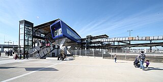
Williams Landing is a suburb in Melbourne, Victoria, Australia, 19 km (12 mi) south-west of Melbourne's Central Business District, located within the City of Wyndham local government area. Williams Landing recorded a population of 9,448 at the 2021 census.
Significant Landscape Overlays or SLOs are one type of Overlay provided by the Victoria Planning Provisions.
Building for Life, Building for Life 12, Adeliladu am Oes 12 Cymru and Building for a Healthy Life are design tools for improving the quality of new homes and neighbourhoods used across England and Wales. The current version in use in England is Building for a Healthy Life .

Water-sensitive urban design (WSUD) is a land planning and engineering design approach which integrates the urban water cycle, including stormwater, groundwater, and wastewater management and water supply, into urban design to minimise environmental degradation and improve aesthetic and recreational appeal. WSUD is a term used in the Middle East and Australia and is similar to low-impact development (LID), a term used in the United States; and Sustainable Drainage System (SuDS), a term used in the United Kingdom.
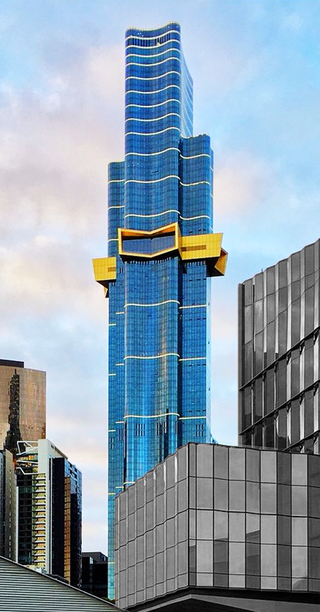
Australia 108 is a residential supertall skyscraper in the Southbank precinct of Melbourne, Victoria, Australia. Having officially topped out in June 2020, it became the tallest building in Australia by roof height, surpassing the Eureka Tower, and the second-tallest building in Australia by full height, surpassed by Q1 Tower.
Garden City is a residential area of Melbourne located in the City of Port Phillip 5 km south-west of the Melbourne CBD and immediately west of Port Melbourne. It was created as a planned residential development along the urban design principles of the early 20th century Garden city movement, initially by the State Bank of Victoria and subsequently developed by the Housing Commission of Victoria between 1926 and 1948.

One Queensbridge was a proposed mixed–used supertall skyscraper to be located in the Southbank precinct of Melbourne, Australia. The skyscraper would have become the tallest building in Melbourne, surpassing the height of Australia 108, and the tallest building in Australia, eclipsing the height of Q1. In addition to being the tallest, the development would have been one of the biggest single–building projects in Australia, encompassing 300,376 square metres of floor area.
References
This article includes a list of references, related reading, or external links, but its sources remain unclear because it lacks inline citations .(April 2008) |