
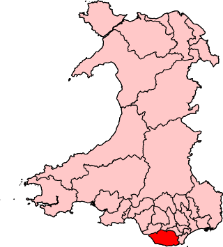
The Vale of Glamorgan, locally referred to as The Vale, is a county borough in the south-east of Wales. It borders Bridgend County Borough to the west, Cardiff to the east, Rhondda Cynon Taf to the north, and the Bristol Channel to the south. With an economy based largely on agriculture and chemicals, it is the southernmost unitary authority in Wales. Attractions include Barry Island Pleasure Park, the Barry Tourist Railway, Medieval wall paintings in St Cadoc's Church, Llancarfan, Porthkerry Park, St Donat's Castle, Cosmeston Lakes Country Park and Cosmeston Medieval Village. The largest town is Barry. Other towns include Penarth, Llantwit Major, and Cowbridge. There are many villages in the county borough.

Glamorgan, or sometimes Glamorganshire, was one of the thirteen historic counties of Wales in the south of Wales. Originally an early medieval petty kingdom of varying boundaries known in Welsh as Morgannwg, which was then invaded and taken over by the Normans as the Lordship of Glamorgan. The area that became known as Glamorgan was both a rural, pastoral area, and a conflict point between the Norman lords and the Welsh princes. It was defined by a large concentration of castles.

Breaksea Point is a promontory at the eastern edge of Gileston's Limpert Bay in the Vale of Glamorgan on the south coast of Wales. Breaksea Point is claimed as the southernmost point of mainland Wales, although that is also claimed of nearby Rhoose Point and the Vale of Glamorgan Council have placed a fixed notice to that effect. Almost 20 km to the east, the Welsh island of Flat Holm is slightly further south in latitude.

Rhoose is a village and community near the sea in the Vale of Glamorgan, Wales, near Barry. The wider community includes villages and settlements such as Font-y-Gary, Penmark, East Aberthaw and Porthkerry. The population of the community in 2011 was 6,160.
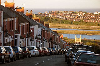
Barry is a town and community in the Vale of Glamorgan, Wales. It is on the north coast of the Bristol Channel approximately 9 miles (14 km) south-southwest of Cardiff. Barry is a seaside resort, with attractions including several beaches and the resurrected Barry Island Pleasure Park. According to Office for National Statistics 2021 estimate data, the population of Barry was 56,605.
The Rhymney Valley is one of the South Wales valleys, with the Rhymney River forming the border between the historic counties of Glamorgan and Monmouthshire. Between 1974 and 1996 a Rhymney Valley local government district also existed. The valley encompasses the villages of Abertysswg, Fochriw, Hengoed, Pontlottyn, Tir-Phil, New Tredegar, Nelson, Rhymney, and Llanbradach, and the towns of Bargoed, Caerphilly, Ystrad Mynach and Aberbargoed.
Vale of Glamorgan is a constituency represented in the House of Commons of the UK Parliament since 2024 by Kanishka Narayan, a Labour MP.

The Vale of Glamorgan Line is a commuter railway line in Wales, running through the Vale of Glamorgan from Barry to Bridgend, via Rhoose and Llantwit Major.

Aberthaw is an area containing the villages of East Aberthaw and West Aberthaw, on the coast of South Wales about 5 miles (8 km) west of Barry. It is home to Aberthaw Cement Works, Aberthaw Lime Works, and Aberthaw Power Station, a decommissioned coal power station that was linked to the South Wales Valleys via the Vale of Glamorgan Railway. The area is historically within the parish of Penmark in the Vale of Glamorgan. The two villages of West and East Aberthaw are separated by the River Thaw. The village of East Aberthaw, near Rhoose, has a 13th-century pub. The village Baptist Chapel and Mission Room no longer exist as such and have been converted for other uses.
Aberthaw Cement Works are cement works in the Vale of Glamorgan near the village of East Aberthaw in Wales.

Aberthaw Lime Works is a derelict structure, located on the South Wales coast, between Fontygary Bay and Aberthaw Power Station. The structure is a Grade II Listed Building. The structure is considered a listed building because it is a well preserved structure from an important regional industry.
Aberthaw High Level railway station was a Vale of Glamorgan Railway station operated by the Barry Railway which served Aberthaw, located near the north shore of the Bristol Channel in the former Welsh county of South Glamorgan, and in the current county of Vale of Glamorgan.
This is a list of the extreme points and extreme elevations in Wales.
Rail transport in Cardiff has developed to provide connections to many other major cities in the United Kingdom, and to provide an urban rail network for the city and its commuter towns in southeast Wales. Today, there are three train operating companies in Cardiff: Great Western Railway, CrossCountry and Transport for Wales.

Bro Radio is a community radio station broadcasting to Barry, Llantwit Major, Penarth and surrounding areas in the Vale of Glamorgan, South Wales.

St Brides Major is a community on the western edge of the Vale of Glamorgan, South Wales. Its largest settlement is the village of St Brides Major, and also includes the villages of Ogmore-by-Sea and Southerndown, and the hamlets of Ogmore Village, Castle-upon-Alun, Heol-y-Mynydd, Norton and Pont-yr-Brown It is notable for coastal geology and scenery, limestone downlands and fossilised primitive mammals, sea cliffs and beaches, two Iron Age hillforts, three medieval castle sites,, two stepping stone river crossings and a clapper bridge. Three long distance paths cross the community. It is the western limit of the Vale of Glamorgan Heritage Coast, and has a visitor centre and tourist facilities.
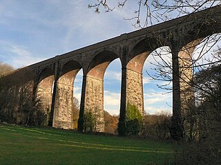
Porthkerry Viaduct is a railway viaduct near Barry in the Vale of Glamorgan, Wales.

The Bulwarks, Porthkerry is a promontory fort in Rhoose, Vale of Glamorgan, on the southern coast of Wales overlooking the Bristol Channel. It probably dates to the Iron Age and continued to be occupied during the Roman period in Britain. The ramparts and ditches along the west side are well preserved, but the fortifications are heavily overgrown.

Rhoose is an electoral ward in the Vale of Glamorgan, Wales, which covers its namesake village, Rhoose, as well as Penmark and the neighbouring community of Llancarfan. The ward elects three county councillors to the Vale of Glamorgan Council.
The Vale of Glamorgan Association Football League is a football league covering the area of the Vale of Glamorgan in Glamorgan, South Wales and the surrounding areas. The leagues are at the seventh and eighth levels of the Welsh football league system.

