
On the morning of 6 December 1917, the French cargo ship SS Mont-Blanc collided with the Norwegian vessel SS Imo in the harbour of Halifax, Nova Scotia, Canada. Mont-Blanc, laden with high explosives, caught fire and exploded, devastating the Richmond district of Halifax. At least 1,782 people were killed, largely in Halifax and Dartmouth, by the blast, debris, fires, or collapsed buildings, and an estimated 9,000 others were injured. The blast was the largest human-made explosion at the time. It released the equivalent energy of roughly 2.9 kilotons of TNT (12 TJ).

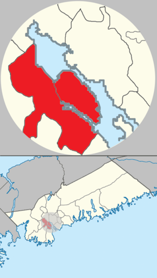
Halifax is the capital and most populous municipality of the Canadian province of Nova Scotia, and the most populous municipality in Atlantic Canada. As of 2023, it is estimated that the population of the Halifax CMA was 518,711, with 348,634 people in its urban area. The regional municipality consists of four former municipalities that were amalgamated in 1996: Halifax, Dartmouth, Bedford, and Halifax County.
Africville was a small community of predominantly African Nova Scotians located in Halifax, Nova Scotia, Canada. It developed on the southern shore of Bedford Basin and existed from the early 1800s to the 1960s. From 1970 to the present, a protest has occupied space on the grounds. The government has recognized it as a commemorative site and established a museum here. The community has become an important symbol of Black Canadian identity, as an example of the "urban renewal" trend of the 1960s that razed similarly racialized neighbourhoods across Canada, and the struggle against racism.

The North End of Halifax is a neighbourhood of Halifax, Nova Scotia occupying the northern part of Halifax Peninsula immediately north of Downtown Halifax.
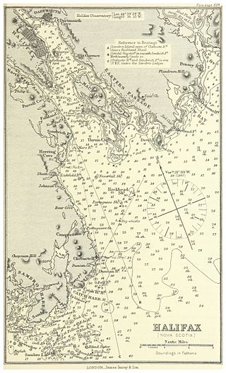
Halifax Harbour is a large natural harbour on the Atlantic coast of Nova Scotia, Canada, located in the Halifax Regional Municipality. Halifax largely owes its existence to the harbour, being one of the largest and deepest ice-free natural harbours in the world. Before Confederation it was one of the most important commercial ports on the Atlantic seaboard. In 1917, it was the site of the world's largest man-made accidental explosion, when the SS Mont-Blanc blew up in the Halifax Explosion on December 6.

Hydrostone is a neighbourhood in the North End of the Halifax Peninsula in the Halifax Regional Municipality, Nova Scotia, Canada. It consists of ten short parallel streets and is bordered by Duffus Street to the north, Young Street to the south, Isleville Street to the west and Novalea Drive to the east. The Hydrostone District has about 9.3 ha of landmass.
The community of Halifax, Nova Scotia was created on 1 April 1996, when the City of Dartmouth, the City of Halifax, the Town of Bedford, and the County of Halifax amalgamated and formed the Halifax Regional Municipality. The former City of Halifax was dissolved, and transformed into the Community of Halifax within the municipality.

The Halifax Armoury is a military structure in central Halifax, Nova Scotia, Canada. The armoury is the home base of The Princess Louise Fusiliers, and several cadet units.

Barrington Street is a major street in Halifax, Nova Scotia, Canada, running from the MacKay Bridge in the North End approximately 7 km south, through Downtown Halifax to Inglis Street in the South End. Its civic numbers range from 950 to 4756 on the Halifax Peninsula street grid numbering system.
Canadian Forces Station Mill Cove is a former Canadian Forces Station and currently a naval radio station located near Hubbards, Nova Scotia. Built in 1967, it is remotely operated by the Canadian Forces from CFB Halifax.

Lawrencetown is a Canadian rural community in the Halifax Regional Municipality in Nova Scotia, Canada. The settlement was established during the eve of Father Le Loutre's War and at the beginning of the French and Indian War.

Veith House is an organization whose mission is to meet the needs of children, individuals and families, with empowerment as an ever-present goal. It is located at 3115 Veith St in the North End of the Halifax Regional Municipality, Nova Scotia, Canada. It is just down the hill from one of Halifax's landmarks, The Hydrostone.
Fairmount, Nova Scotia is a neighbourhood of Halifax, Nova Scotia, Canada.
Forest Hills is a subdivision in the community of Cole Harbour and in the Canadian province of Nova Scotia, located in the Halifax Regional Municipality.
The Nova Scotia Cotton Manufacturing Company was a cotton mill located in Halifax, Nova Scotia which was founded in 1882 and destroyed with great loss of life by the Halifax Explosion in 1917.

The Bedford Magazine explosion was a conflagration resulting in a series of explosions from July 18 to 19, 1945, in Bedford, Nova Scotia, Canada. During World War II, the adjacent cities of Halifax and Dartmouth provided heavy support for Canada's war effort in Europe.
Upper Hammonds Plains is a Canadian suburban community located in Nova Scotia's Halifax Regional Municipality.

The following outline is provided as an overview of and topical guide to Nova Scotia:

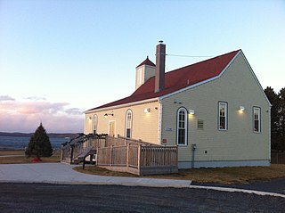
New Horizons Baptist Church is a Baptist church in Halifax, Nova Scotia that was established by Black Refugees in 1832. When the chapel was completed, black citizens of Halifax were reported to be proud because it was evidence that former slaves could establish their own institutions in Nova Scotia. Under the direction of Richard Preston, the church laid the foundation for social action to address the plight of Black Nova Scotians. It is affiliated with the Canadian Baptists of Atlantic Canada.

The North Street Station was the railway terminal for Halifax, Nova Scotia from 1877 to 1920. It was built by the Intercolonial Railway in the North End of Halifax and was the second largest railway station in Canada when it opened in 1878. Damaged, but repaired after the Halifax Explosion, it served until the current Halifax terminal location opened as part of the Ocean Terminals project in the city's South End in 1919.

