This article does not cite any sources .(May 2020) (Learn how and when to remove this template message) |
| Richmond River (St. Vincent) | |
|---|---|
| Location | |
| Country | Saint Vincent and the Grenadines |
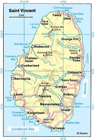
The Richmond River is a river of Saint Vincent and the Grenadines.
This article does not cite any sources .(May 2020) (Learn how and when to remove this template message) |
| Richmond River (St. Vincent) | |
|---|---|
| Location | |
| Country | Saint Vincent and the Grenadines |
The Richmond River is a river of Saint Vincent and the Grenadines.

Grenada is an island country located between the Caribbean Sea and Atlantic Ocean, north of Trinidad and Tobago. It is located at 12°07′N61°40′W. There are no large inland bodies of water on the island, which consists entirely of the state of Grenada. The coastline is 121 km long. The island has 15 constituencies and speaks English and Grenadian Creole. It is volcanic in origin and its topography is mountainous.

Saint Vincent and the Grenadines, also frequently known simply as Saint Vincent, is an Anglo-Caribbean country of several islands in the Lesser Antilles island arc, in the southeast Windward Islands, which lies in the West Indies at the southern end of the eastern border of the Caribbean Sea where the latter meets the Atlantic Ocean.

Saint Vincent and the Grenadines is an island state in the Windward Islands of the Lesser Antilles, an island arc of the Caribbean Sea in North America. The country consists of the main island of Saint Vincent and the northern two-thirds of the Grenadines, a chain of small islands stretching south from Saint Vincent to Grenada. Its total land area is 390 km² of which 342.7 km² is the main island of Saint Vincent. The country's capital is at Kingstown on Saint Vincent.
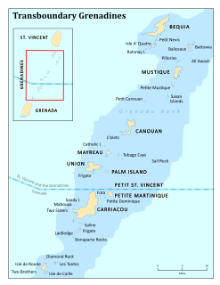
The Grenadines are a chain of small islands that lie on a line between the larger islands of Saint Vincent and Grenada in the Lesser Antilles. Nine are inhabited and open to the public : Bequia, Mustique, Canouan, Union Island, Petit St Vincent, Palm Island and Mayreau, all in Saint Vincent and the Grenadines, plus Petite Martinique and Carriacou in Grenada. Several additional privately-owned islands such as Calivigny are also inhabited. Notable uninhabited islands of the Grenadines include Petit Nevis, used by whalers, and Petit Mustique, which was the centre of a prominent real estate scam in the early 2000s.
Area code 784 is the local telephone area code of Saint Vincent and the Grenadines. The 784 area code, or "SVG" was created during a split from the original 809 area code which began permissive dialing 1 June 1998 and ended 1 June 1999.

Charlotte is the largest parish of Saint Vincent and the Grenadines, situated on the eastern coast of the island of Saint Vincent. With an area of 149 km², its size is comparable to that of the British Virgin Islands.) The parish has the longest coastline of all the parishes and is also larger than the three smallest parishes combined. The parish possesses a very rough and rugged topography with very little flat land occurring towards the coast. as a result of these features, parts of the north of the parish cannot be accessed by a main road. Up until the building of a bridge over the Rabacca Dry River access to the north side of the river was not possible when rain caused the river to swell and make the path impassable.
Saint David is an administrative parish of Saint Vincent and the Grenadines, on the island of Saint Vincent. Its capital is Chateaubelair.
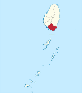
Saint George is an administrative parish of Saint Vincent and the Grenadines, situated in the most southerly portion of the island of Saint Vincent. With an area of 52 km² it is the country's third largest parish by total area. According to the 2000 census it has a population of approximately 52,400 making it the most populous parish in Saint Vincent and the Grenadines and by extent, the most densely populated as well. Its population accounts for 44% of that of the country and its area, only 13%.

Saint Patrick is an administrative parish of Saint Vincent and the Grenadines, on the island of Saint Vincent. The parish consists of the middle portion of the leeward side of the main island. Its capital is Barrouallie.

Grenadines is an administrative parish of Saint Vincent and the Grenadines, comprising the islands of the Grenadines other than those belonging to Grenada. The capital is Port Elizabeth.

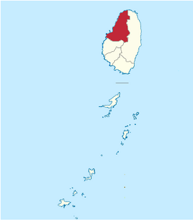
Saint Andrew is an administrative parish of Saint Vincent and the Grenadines, on the island of Saint Vincent. Its capital is Layou.
The Colonarie River is the longest river in Saint Vincent and the Grenadines. Located on the main island of Saint Vincent, it flows from the northeast slopes of Grand Bonhomme peak in a northeastward direction, turning east before flowing into the Atlantic Ocean on the island's central east coast. The town of Colonarie is located on the banks of the river.

The Roman CatholicDiocese of Kingstown is a diocese of the Latin Rite of the Roman Catholic Church in the Caribbean. The diocese comprises the entirety of the nation of Saint Vincent and the Grenadines. The diocese is a suffragan diocese of the Archdiocese of Castries and a member of the Antilles Episcopal Conference.

The St Vincent and the Grenadines Botanic Gardens is located in Kingstown, Saint Vincent and the Grenadines. It is one of the oldest in the Western Hemisphere and perhaps the oldest in the tropical world. Conservation of rare species of plants has been practiced here since 1765. The Nicholas Wildlife Aviary complex located within the Gardens also maintains a captive breeding program to conserve the vulnerable Saint Vincent amazon.

The Wallilabou River is a river in the northwest of Saint Vincent. It rises in the Grand Bonhomme Mountains in the centre of the island and flows Northwest to reach the Caribbean Sea North of Barroulie.The Wallilabou Falls-a tourist attraction-is located on this river, a short walk Northeast along the Leeward Highway. Several of the scenes from the film Pirates of the Caribbean: The Curse of the Black Pearl were filmed close to the mouth of the river.
The Rabacca Dry River is a river of Saint Vincent and the Grenadines. It is a seasonal river and will only flow like a normal when there is heavy rainfall. It is located on the outskirts of Georgetown. It was formed as a result of the eruption of the La Soufriere volcano, there is its source.
The Greathead River is a river of Saint Vincent and the Grenadines.
Edinboro is a town located on the outskirts of the capital, Kingstown, Saint Vincent in the country of St. Vincent and the Grenadines. It is located in Saint Andrew Parish and serviced by Argyle International Airport. The town was named after the Scottish capital Edinburgh, from whence its first settlers came. Fort Charlotte, a tourist attraction for the island, is located in Edinboro.
St. Vincent Girls' High School is a secondary education facility opened in Kingstown on the island of St. Vincent in Saint Vincent and the Grenadines. The school was founded by Mary L. Ince in 1911 at the corner of Linley and Tyrell Street in Kingstown. In 1914, the government took over operation of the school and made Ince the headmistress. The following year, students began participating for the first time in the Cambridge Examinations. By 1918, the school had a staff of 3 teachers and 16 students and functioned as a secondary school for middle-class pupils, who were able to afford the 6£ per year fee, as elites could afford to send their children to Barbados or Britain for higher education. In 1935, the school relocated to its present location on Murray Road in Kingstown to a site known as the Judges Lodge. The school's students consistently rank highly in the Caribbean Secondary Education Certificate examinations, with pass rates over 95%. In every year since 2000, the school has had the highest rate of students passing the examination in the country.
Coordinates: 13°18′N61°15′W / 13.300°N 61.250°W
| This article related to a river in Saint Vincent and the Grenadines is a stub. You can help Wikipedia by expanding it. |