
The Rivière des Mille Îles is a channel of the Ottawa River in southwestern Quebec, Canada and runs into the Rivière des Prairies. It is 42 kilometres (26 mi) long.

The Muskoka River is a river in the Muskoka District of Ontario, Canada. The river is the third largest river draining the southern Ontario land mass by average annual flow.
Argenteuil County is an historic county in southwestern Quebec, Canada. It was located on the Ottawa River between Gatineau and Montreal. The county seat was Lachute. Argenteuil was bounded on the north by Terrebonne County, on the east by Deux-Montagnes County, on the west by Papineau County and on the south by the United Counties of Prescott and Russell in Ontario.
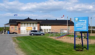
Pointe-Fortune is a municipality in southwestern Quebec, Canada, on the Ottawa River in Vaudreuil-Soulanges Regional County Municipality, northwest of Montreal. The population at the 2021 Census was 582.
Huntingdon County is an historical county in southwestern Quebec, Canada. It is named after the town and county of the same name in east central England. It is situated in the Montreal South Shore region of Montérégie, one of the roughly 12 regions of Quebec. The county was bounded entirely on its south by the Canada–US border, along its northwestern flank by Lake St-Francis of the Saint Lawrence River to its most northern point on the river at 45°13′ N and 74°13′ W, to the east by Saint-Jean County, with its easternmost point at 45°5.5' N and 73°31′ W and to the north from east to west by Napierville County, Châteauguay County, and Beauharnois County. On the other side of the Saint Lawrence River is Soulanges County, Quebec, the Township of Lancaster and the Township of Charlottenburgh in Glengarry County, Ontario, and the Township of Cornwall in Stormont County, Ontario.
Vaudreuil—Soulanges is a federal electoral district in Quebec, Canada, that has been represented in the House of Commons of Canada since 1867.

The Rouge River is a river flowing in the Laurentides, in the municipality of Grenville-sur-la-Rouge, in the Argenteuil Regional County Municipality, in the administrative region of Laurentides, in the west of Quebec, in western Quebec, Canada.
Ormstown is a municipality in Quebec, Canada, which is situated on the Chateauguay River in the heart of the Chateauguay Valley. It is approximately one hour southwest of Montreal and 20 minutes north of New York State in the United States. The population as of the 2021 Canadian census was 3,917.

Route 148 is an east-west highway in Quebec, Canada. It runs from junction of Autoroute 13 and Autoroute 440 in Laval in the Montreal region to the Ontario-Quebec border in L'Isle-aux-Allumettes in western Quebec. For most of its length, Route 148 follows the north shore of the Ottawa River where it acted as the principal route between communities in the Outaouais region until the completion of Autoroute 50 in 2012. At the Ontario-Quebec border in L'Isle-aux-Allumettes Route 148 continues into Ontario as Highway 148.
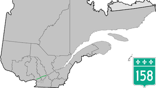
Route 158 is an east-west arterial road running between Lachute and Berthierville, north of the Ottawa and Saint Lawrence rivers, in the Laurentides region.

Route 201 is a north/south provincial highway within the Canadian province of Quebec, running between Route 202 in Franklin and Route 342 in Rigaud. Its total length is approximately 70 kilometres.
The Whitefish River is an 11.9-mile-long (19.2 km) river on the Upper Peninsula of the U.S. state of Michigan. The mouth of the river is in Delta County at 45°54′34″N86°58′01″W on the Little Bay De Noc of Lake Michigan. The main branch of the river is formed by the confluence of the east and west branches at 46°03′25″N86°52′17″W.

Vaudreuil is a provincial electoral district in the Montérégie region of Quebec, Canada that elects members to the National Assembly of Quebec. The biggest municipality in the district is Vaudreuil-Dorion.

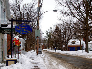
Collège Bourget is a French-language private education institution in Rigaud, Quebec, Canada. Despite its former religious involvements under the Roman Catholic branch, the students are no longer obliged to practice Catholicism or any other religion. The school provides education at the preschool, primary, and secondary lebels and even offers a grade 12. Bourget welcomes about 1100 day-students and offers a boarding service for high-school students, notably from the international program.
The Daaquam River is a river primarily flowing in the administrative region of Chaudière-Appalaches, at South of Quebec in Canada and northern Maine, in United States. The river runs from its source, south of Sainte-Justine, northeast across the Canada–United States border to the Northwest Branch of the Saint John River in Maine.

Ski Mont Rigaud is an alpine ski facility on the slopes of Rigaud Mountain, in the municipality of Rigaud, Quebec. It is in the suburbs of Montreal, near the Ontario border, one of two alpine ski hills that still operate in the suburbs of Montreal, the other being Ski Mont Saint Bruno. The hill is located only 30 minutes off Montreal island, about 25 km (16 mi) to the west. It is the only ski hill in westernmost Quebec south of the Ottawa River. Nearby is the Nordic skiing centre, "The Escapade".

Rivière du Nord has its source at Lac Brûlé, it's located in the Laurentides administrative region, Argenteuil Regional County Municipality, Quebec, in Canada.

The Coaticook River is a north-flowing river rising in Vermont, United States, and located primarily in the Estrie region of Quebec, Canada. The mouth of the river is located north of Waterville and south of Lennoxville, near the southern border of the city of Sherbrooke, at the Massawippi River. Via the Massawippi and the Saint-François River, it is part of the St. Lawrence River watershed.

Saint-Eugène is a rural, Franco-Ontarian locality situated in the Township of East Hawkesbury in the United Counties of Prescott and Russell in Ontario (Canada). It is on the interprovincial border with Quebec, near Highway 417 between Ottawa and Montreal.
