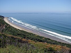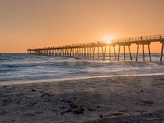
Southern California is a geographic and cultural region that generally comprises the southern portion of the U.S. state of California. It includes the Los Angeles metropolitan area as well as the Inland Empire. The region generally contains ten of California's 58 counties: Imperial, Kern, Los Angeles, Orange, Riverside, San Bernardino, San Diego, Santa Barbara, San Luis Obispo and Ventura counties.

Ventura County is a county located in the southern part of the U.S. state of California. As of the 2020 census, the population was 843,843. The largest city is Oxnard, and the county seat is the city of Ventura.

Channel Islands National Park consists of five of the eight Channel Islands off the Pacific coast of the U.S. state of California. Although the islands are close to the shore of the densely populated state, they have been relatively undeveloped. The park covers 249,561 acres (100,994 ha), of which 79,019 acres (31,978 ha) are federal land. The Nature Conservancy owns and manages 76% of Santa Cruz Island, the largest of the eight.
Rincon(Spanish, "angle" or "corner") is a surf spot located at the Ventura and Santa Barbara County line in Southern California, United States. Also known as the "Queen of the Coast", Rincon is one of the most famous surf spots in California, known around the world for its well-formed waves and long rides. The book 100 Best Surf Spots in the World rates Rincon at 24. It is best at low tide during the winter months when swells are coming mostly from the west and northwest. There is a gated residential community that occupies most of the Rincon beachfront. Public access is provided at parking lots on both sides of the gated community, with restrooms and a picnic area in the upper parking lot, Rincon Beach Park.
La Conchita is a small unincorporated community in western Ventura County, California, on U.S. Route 101 just southeast of the Santa Barbara county line. The ZIP Code is 93001, and the community is inside area code 805.
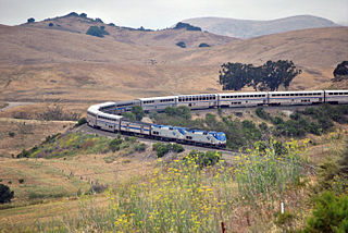
The Coast Line is a railroad line between Burbank, California and the San Francisco Bay Area, roughly along the Pacific Coast. It is the shortest rail route between Los Angeles and the Bay Area.
Rincon or Rincón may refer to:

KSBL is a commercial FM radio station licensed to Carpinteria, California, and serves the Santa Barbara and Oxnard—Ventura, California radio markets. The station is owned by Rincon Broadcasting and broadcasts an adult contemporary radio format, switching to Christmas music for part of November and December. Two syndicated shows are heard weekdays on KSBL: Delilah, an evening call-in and request show, and Intelligence for Your Life with John Tesh heard overnight.

KVYB is a commercial radio station that is licensed to Oak View, California, United States, and serves the Oxnard—Ventura, California area. Owned by Cumulus Media, the station airs a contemporary hit radio (CHR) format.

KSPE is a commercial radio station that is licensed to Ellwood, California, a district of Goleta in Santa Barbara County. It is owned by Rincon Broadcasting and broadcasts a classic regional Mexican music format. The KSPE studios and offices are on East Cota Street in Santa Barbara and the transmitter is located on West Camino Cielo in the Los Padres National Forest. While the station's effective radiated power is only 810 watts, the tower is 2,949 feet (899 m) in height above average terrain, making KSPE a Class B FM station covering the Santa Barbara radio market and parts of Oxnard—Ventura.

Rincon Island is a small 2.3-acre artificial island located off Mussel Shoals in Ventura County, California on public land leased from the California State Lands Commission (CSLC). The island is situated approximately 3,000 feet (910 m) offshore in 55 feet (17 m) of water. The island was constructed in 1958 for the specific purpose of well drilling and oil and gas production. It is near the seaside communities of Mussel Shoals and La Conchita. The island is connected to the mainland by the Richfield Pier.
Dulah is a former station (siding) along the Union Pacific Railroad tracks on the north coast of Ventura County, California. Solimar Beach Colony, a gated community of 70 homes, has been built here and is the first beach community north of the city of Ventura along the Pacific Coast Highway. This north coast portion of the county between Ventura and the Santa Barbara County line is commonly known as the Rincon, sharing the name of the community at Rincon Point, which is located at the county line. It is within the Ventura Unified School District and has a Ventura zip code.

Greka Energy, legally HVI Cat Canyon Inc., is a privately held company engaged in hydrocarbon exploration principally in Santa Barbara County, California. Formed in 1999 after the acquisition and merger of several smaller firms, it is a subsidiary of Greka Integrated, Inc., a holding company headquartered in Santa Maria, California, and is wholly owned by Randeep Grewal.
Rancho El Rincon was a 4,460-acre (18.0 km2) Mexican land grant in present day Santa Barbara County and Ventura County, California given in 1835 by Governor José Figueroa to Teodoro Arellanes. "Rincon" means "corner" in Spanish. The grant extended along the Pacific coast at the Santa Barbara and Ventura County line and encompassed Rincon Point, Rincon State Beach and present day La Conchita.
The Rincon Parkway is a portion of California State Route 1 along the north coast of Ventura County, California. This narrow coastal area north of the city of Ventura and south of the Santa Barbara County line is commonly referred to as The Rincon. The automobile route along this portion of coastline opened up in 1913 as the Rincon Causeway or the Rincon Sea Level Road as the first driveable coastal route for motorists traveling between San Francisco and Los Angeles, California. The access road alongside the railroad bed, that cut through the area in 1886, provided the basis for building the Rincon Sea Level Road.
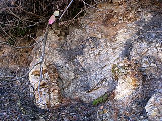
The Rincon Formation is a sedimentary geologic unit of Lower Miocene age, abundant in the coastal portions of southern Santa Barbara County, California eastward into Ventura County. Consisting of massive to poorly bedded shale, mudstone, and siltstone, it weathers readily to a rounded hilly topography with clayey, loamy soils in which landslides and slumps are frequent. It is recognizable on the south slopes of the Santa Ynez Mountains as the band at the base of the mountains which supports grasses rather than chaparral. Outcrops of the unit are infrequent, with the best exposures on the coastal bluffs near Naples, in the San Marcos Foothills, at the Tajiguas Landfill, and in road cuts. The geologic unit is notorious as a source of radon gas related to its high uranium content, released by radioactive decay.

Ventura Fault also Ventura-Pitas Point Fault is an offshore and onshore fault system of Southern California, beginning around Santa Barbara coming onshore in Ventura with an eastward heading, its extension is unknown but presumed to head for San Bernardino. It is among a network of faults in the area, potentially connecting to San Cayetano Fault, Lion Fault, and Red Mountain Fault.
Rincon Creek is a creek that marks the boundary between Santa Barbara and Ventura County, California. The Santa Barbara County - Ventura County Line follows Rincon Creek from near its source in the Santa Ynez Mountains near Divide Peak, at 34°28′36″N119°26′29″W, down to its mouth on the Pacific Ocean, just east of the extremity of Rincon Point.

The Thomas Fire was a massive wildfire that affected Ventura and Santa Barbara Counties, and one of multiple wildfires that ignited in southern California in December 2017. It burned approximately 281,893 acres before being fully contained on January 12, 2018, making it the largest wildfire in modern California history at the time. It was surpassed by the Ranch Fire, part of the Mendocino Complex, in August 2018. The fire is currently the seventh-largest wildfire in modern California history, as of 2021. The fire was officially declared out on June 1, 2018, after more than two months in which no hotspots were detected. The Thomas Fire destroyed at least 1,063 structures, while damaging 280 others; and the fire caused over $2.2 billion in damages, including $230 million in suppression costs, becoming the seventh-most destructive wildfire in state history at the time. As of August 2020, the Thomas Fire is California's tenth-most destructive wildfire. Ventura's agriculture industry suffered at least $171 million in losses due to the Thomas Fire.
Point Broadcasting LLC is an American radio broadcasting company based in Ventura, California. The company is the owner of several radio groups in Southern California, doing business as Gold Coast Broadcasting LLC in the Oxnard—Ventura radio market, Rincon Broadcasting LLC in Santa Barbara, and High Desert Broadcasting LLC in the Antelope Valley. As of February 2019, Point owns and operates 21 full-power radio stations, including seven AM stations and 14 on the FM dial.
