
Tanque Verde is a suburban census-designated place (CDP) in Pima County, Arizona, United States, northeast of Tucson. The population was 16,195 at the 2000 census.
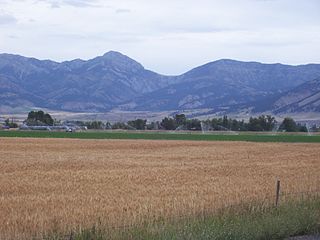
The Bridger Range, also known as the Bridger Mountains, is a subrange of the Rocky Mountains in southwestern Montana in the United States. The range runs mostly in a north–south direction between Bozeman and Maudlow. It is separated from the Gallatin Range to the south by Bozeman Pass; from the Horseshoe Hills to the west by Dry Creek; from the Crazy Mountains to the east by the Shields River valley; and from the Big Belt Mountains to the north by Sixteen Mile Creek. The highest point in the Bridger Range is Sacagawea Peak, which is visible to the northeast from Bozeman.

The Avra Valley is a 50-mile (80 km) long northwest-southeast valley, bordering the west of Tucson, Arizona. The Tucson Mountains are at the valley's center-east, with suburbs ranging east of the Tucson Mountains and trending northwest to the Avra Valley's northeast. This entire northwest stretch from Tucson contains the northwest trending Interstate 10, the route to Casa Grande and Phoenix. The northeast of the valley contains Marana on I-10, the Pinal Airpark, an aircraft storage park, and other communities along I-10. Avra Valley Airport is a general aviation airport in Marana, located about 15 miles northwest of Tucson and being used for storage of classic propeller-era airliners.

The Tortolita Mountains are a modest mountain range northwest of Tucson, Arizona, USA, at the northern boundaries of Oro Valley and Marana, two suburbs of Tucson. Peak elevation is 4,696 feet. Much of the mountain range is protected within the Tortolita Mountain Park, established in 1986 by Pima County and slated for further expansion. Public access to the park, especially from Marana, has become contentious.

Tres Alamos is a ghost town in Cochise County in the U.S. state of Arizona. The town was settled in 1874 in what was then the Arizona Territory.

The Mazatzal Mountains are a mountain range in south central Arizona, about 30–45 miles northeast of Phoenix and the Phoenix metropolitan area. The origin of the name remains obscure but one possibility is that it is from the Aztec language meaning "place of the deer". The crest of the Mazatzals forms the county line between Maricopa County and Gila County. SR 87, the Beeline Highway, traverses the Mazatzals on its way to Payson. The highest peak is Mazatzal Peak at 7,903 feet (2,409 m). They also include the Four Peaks, with elevation 7,659 ft, 2,334 m; a prominent mountain and landmark of the eastern Phoenix area.

Fall River rises on the Madison and Pitchstone plateaus in the southwest corner of Yellowstone National Park, Wyoming and flows approximately 64 miles (103 km) to its confluence with the Henrys Fork of the Snake River near Ashton, Idaho. Historically, the river was referred to as the Middle Fork of the Snake River or as Fall River or the Falls River by trappers and prospectors as early as the 1830s. It was officially named the Falls River by the 1872 Hayden Geological Survey, but was always called Fall River by the locals and so the U.S. Board on Geographic Names changed the official name to Fall River in 1997 at the request of Idaho authorities. The river is home to numerous waterfalls and cascades in its upper reaches.
The West Silver Bell Mountains are a small 10 mile (16 km) long mountain range of south-central Arizona, United States. The range lies in the north-central arid Sonoran Desert; the Madrean Sky Islands region of southeast Arizona, around Tucson is adjacent to the southeast.
The Little Rincon Mountains are a small range of mountains, lying to the east of the Rincon Mountains, at Tucson, of eastern Pima County, Arizona. The range is located in northwest Cochise County and is part of the western border of the San Pedro River and Valley, the major valley and river of western Cochise County. The river is northward flowing to meet the Gila River; its headwaters are south of the US-Mexico border in northern Sonora. A small part of the Little Rincon range's southwest lies in Pima County.
The Black Hills of Greenlee County are a 20 mi (32 km) long mountain range of the extreme northeast Sonoran Desert bordering the south of the White Mountains of eastern Arizona's transition zone.
The Aquarius Mountains are a 45-mi (72 km) long mountain range in southeast Mohave County, Arizona. The range lies in the northwest of the Arizona transition zone, and at the southwest of the Coconino Plateau, a subsection of the Colorado Plateau.
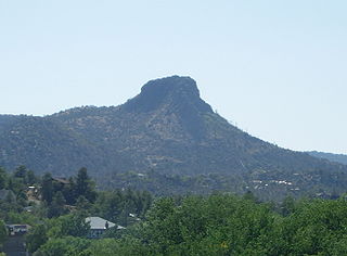
The Sierra Prieta is a 14-mi (23 km), long mountain range in central-northwest Arizona. The range is the mountainous region west of Prescott, with prominent Thumb Butte, 6,514 feet (1,985 m), a volcanic plug, on the city's west perimeter.
Little Dragoon Mountains, are included in the Douglas Ranger District of Coronado National Forest, in Cochise County, Arizona. The summit of the range is the center peak of the three Mae West Peaks,32°06′00″N110°07′20″W, 6 miles northwest of Dragoon, Arizona, at 6588 feet(2008m).

Laguña Creek also formerly also known as Tyende Creek, is a stream in the Navajo and Apache Counties of Arizona. Laguña Creek has its source at 36°41′15″N110°30′36″W, at the conflence of Long Canyon and Dowozhiebito Canyon at an elevation of 6325 feet / 1928 meters at the head of Tsegi Canyon. Its mouth is in the Chinle Valley at its confluence with Chinle Wash which together forms Chinle Creek, at an elevation of 4774 feet / 1455 meters. Chinle Creek is a tributary of San Juan River which is in turn a tributary of the Colorado River.
Carrizo Valley is a valley between the Vallecito Mountains and Carrizo Badlands to the north and the Tierra Blanca Mountains, Jacumba Mountains and Coyote Mountains on the south, in San Diego County, California. Its mouth is at an elevation or 623 feet / 190 meters. Its source is at an elevation of 1,315 feet at 32°58′07″N116°18′37″W at the mouth of the narrow canyon where Vallecito Creek passes between the Tierra Blanca Mountains and Vallecito Mountains.
Rincon Valley is a valley through which the Rio Grande flows in New Mexico. Rincon Valley heads at 33°02′54″N107°16′41″W at an elevation of 4,195 feet in a narrow gap between the Caballo Mountains on the east and bluffs on the west bank of the Rio Grande south of where Red Canyon meets the river, in Sierra County, New Mexico. Its mouth is at an elevation of 3,973 feet / 1,211 meters where it emerges from a narrow canyon between the Selden Hills on the northeast bank of the river and Robledo Mountains on the southwest bank, into the Mesilla Valley at Radium Springs in Doña Ana County, New Mexico.
Quién Sabe Creek is a tributary stream of Los Muertos Creek, in San Benito County, California. Los Muertos Creek is in turn tributary to Tres Pinos Creek and Tres Pinos to the San Benito River, itself tributary to the Pajaro River. Quien Sabe Creek's mouth is at an elevation of 1,470 feet / 448 meters at its confluence with Los Muertos Creek. Its source is at 36°54′40″N121°12′55″W an elevation of 2,800 feet / 853 meters in the Diablo Range.


