The Gatun Dam is an earthen dam across the Chagres River in Panama, near the town of Gatun. The dam, constructed between 1907 and 1913, is a crucial element of the Panama Canal; it impounds the artificial Gatun Lake, which carries ships 33 kilometres (21 mi) of their transit across the Isthmus of Panama. In addition, a hydro-electric generating station at the dam generates electricity which is used to operate the locks and other equipment in the canal.
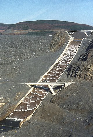
A spillway is a structure used to provide the controlled release of water downstream from a dam or levee, typically into the riverbed of the dammed river itself. In the United Kingdom, they may be known as overflow channels. Spillways ensure that water does not damage parts of the structure not designed to convey water.

Pathfinder Dam is a masonry dam, located on the North Platte River, approximately 47 miles (76 km) southwest of Casper, Wyoming. It was constructed from 1905 to 1909 as part of the North Platte Project and has been modified several times since then. It is included on the National Register of Historic Places. Construction of the dam created Pathfinder Reservoir which provides water storage for 226,000 acres (910 km2) of irrigation in Wyoming and Nebraska. The dam is named for General John Charles Fremont, who had explored the area in 1842 and was nicknamed the "Pathfinder of the West."

The Robert-Bourassa generating station, formerly known as La Grande-2 (LG-2), is a hydroelectric power station on the La Grande River that is part of Hydro-Québec's James Bay Project in Canada. The station can generate 5,616 MW and its 16 units were gradually commissioned between 1979 and 1981. Annual generation is in the vicinity of 26500 GWh.
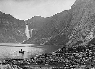
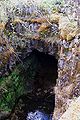
Ringedalsvatnet is a lake in Ullensvang Municipality in Vestland county, Norway. The 7-square-kilometre (2.7 sq mi) lake sits just east of the village of Skjeggedal and about 3.5 kilometres (2.2 mi) east from the village of Tyssedal, which sits on the shore of the Sørfjorden. The lake is the main reservoir for a hydroelectric power station in Tyssedal which provides electricity for the power intensive industries in the nearby town of Odda. The 521-metre (1,709 ft) wide and 33-metre (108 ft) high Ringedals Dam was constructed from 1910–1918.

The Prospect Reservoir is a heritage-listed 50,200-megalitre potable water supply and storage reservoir created by the Prospect Dam, across the Prospect Creek located in the Western Sydney suburb of Prospect, in New South Wales, Australia. The eastern bounds of the reservoir are a recreational area and the western periphery are within the bounds of Western Sydney Parklands. It was added to the New South Wales State Heritage Register on 18 November 1999.
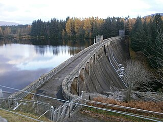
Laggan Dam is a mass concrete gravity dam located on the River Spean south west of Loch Laggan in the Scottish Highlands. It forms the second reservoir for the Lochaber hydroelectric scheme.

The Sudbury Dam Historic District is a historic district on the southeastern end of Sudbury Reservoir off Massachusetts Route 30 in Framingham and Southborough, Massachusetts. The district encompasses the Sudbury Dam, which impounds the reservoir, and an area encompassing several historic structures located below the dam. The area includes water-supply-related structures from three phases of development of the Greater Boston water supply system. It was listed on the National Register of Historic Places in 1990.

The Norwegian Museum of Hydropower and Industry is a cultural history museum at Odda in Vestland county, Norway. The museum is located in the village of Tyssedal. The museum is dedicated to the industrial history of Odda and Tyssedal, and more generally to history related to rivers and water, hydropower production, electricity, power intensive industry and its society.

Cougar Dam is a 519-foot (158 m) tall rockfill hydroelectric dam in the U.S. state of Oregon. It has a gated concrete spillway and a powerhouse with two turbines totaling 25 megawatts of electric power.

Deriner Dam is a concrete double-curved arch dam on the Çoruh River 5 km (3.1 mi) east of Artvin in Artvin Province, Turkey. The main purpose of the dam is hydroelectric power production and additionally flood control. Construction on the dam began in 1998, the reservoir began to fill in February 2012 and the power station was completed by February 2013. It will have a 670 MW power house and is the tallest dam in Turkey. The dam is being implemented by Turkey's State Hydraulic Works and constructed by a consortium of Turkish, Russian and Swiss companies.

Richard B. Russell Dam is a concrete-gravity and embankment dam located on the Savannah River at the border of South Carolina and Georgia, creating Richard B. Russell Lake. The dam was built by the U.S. Army Corps of Engineers between 1974 and 1985 for the purposes of flood control, hydroelectricity, recreation, additional stream flow regulation, water supply, and fish and wildlife management. The concrete structure of the dam spans 1,904 feet (580 m) and rises 210 feet (64 m) above the riverbed, housing a hydro-power plant with an installed 600 megawatts (800,000 hp) capacity. The Richard B. Russell Dam is the final large dam completed by the U.S. Army Corps in the Savannah River Basin and lies 30 miles downstream from the Hartwell Dam (1962) and 37 miles (60 km) upstream from the J. Strom Thurmond Dam (1954).

The Aldeadávila Dam is a Spanish concrete arch-gravity dam, straddling the border between Spain and Portugal on the Duero River. The nearest town is Aldeadávila de la Ribera in the Province of Salamanca, about 11.3 kilometres (7.0 mi) to the east. The nearest Portuguese town is Fornos in Bragança District, about 8 kilometres (5.0 mi) to the southwest. The Portuguese side of the river around the dam site lies within the Arribes del Duero Natural Park.
The Governor Bento Munhoz da Rocha Netto Hydroelectric Plant, formerly known as Foz do Areia, is dam and hydroelectric power plant on the Iguazu River near Foz do Areia in Paraná, Brazil. It is the furthest dam upstream of the Iguazu Falls and was constructed between 1976 and 1980. The power station has a 1,676 megawatts (2,248,000 hp) capacity and is supplied with water by a concrete face rock-fill embankment dam.

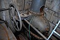
Mågelibanen was a funicular with double track line arranged on a timber trestle work in Skjeggedal in Odda, Hordaland, Norway. From the station close to the Ringedals Dam and the lake Vetlavatn, the funicular ascended 430 meters (1,411 ft) to the top station Mågelitopp, 860 meters (2,822 ft) above sea level. The Mågelibanen was part of an industrial landscape connected to the listed hydroelectric power station in Tyssedal and the industry in the city of Odda.

New Don Pedro Dam, often known simply as Don Pedro Dam, is an earthen embankment dam across the Tuolumne River, about 2 miles (3.2 km) northeast of La Grange, in Tuolumne County, California. The dam was completed in 1971, after four years of construction, to replace the 1924 concrete-arch Don Pedro Dam.

Techi Dam is a concrete thin arch dam on the Dajia River in Heping District, Taichung, Taiwan. Forming the 454 ha (1,120-acre) Techi Reservoir (德基水庫), the dam is built in the Tachien Gorge in Heping District, providing hydroelectric power, irrigation water, and some flood control, and is operated by the Taiwan Power Company. At 180 m (590 ft), it is the highest dam in Taiwan and one of the tallest dams in the world. The dam was completed in 1974 after five years of construction.
Skjeggedal is a small village in the municipality of Ullensvang in Vestland county, Norway. The village lies on the northern shore of the lake Vetlevatnet, about 5 kilometres (3.1 mi) northeast of the village of Tyssedal and about 10 kilometres (6.2 mi) northwest of the town of Odda. The village is mostly made up of holiday cottages and a large hydroelectric power station near the large Ringedals Dam on the lake Ringedalsvatnet.

Wujie Dam is a concrete gravity dam on the Zhuoshui River in Ren'ai Township, Nantou County, Taiwan. The dam was built in two stages, from 1919 to 1922 and 1927–1934, and serves primarily to divert water from the Zhuoshui River to a storage reservoir at Sun Moon Lake and its associated hydroelectric projects. During the Japanese occupation of Taiwan it was known as Bukai Dam.

Pamba Dam is a gravity dam built on the Pamba river in the Ranni forest area of Seethathodu panchayat in Pathanamthitta district of Kerala, India. It was built in 1967 as part of the Sabarigiri Hydroelectric Project. Sabarigiri Hydro Electric Project (IHEP) is the second largest hydro electric project in Kerala. Pamba dam's reservoir is connected to the nearby Kakki dam's reservoir by a 3.21 km (1.99 mi) long underground tunnel. The dam is 281 m (922 ft) long and 57.2 m (188 ft) high and is located at an elevation of 981.45 m (3,220.0 ft) above sea level. The dam is located in a forest area adjacent to the Periyar National Park. The water stored in the Pamba and Kakki dams is conveyed to the Sabarigiri powerhouse through penstock pipes. The dam was commissioned in 1967.