
Kirkcudbrightshire, or the County of Kirkcudbright or the Stewartry of Kirkcudbright, is a historic county, registration county and lieutenancy area in the informal Galloway area of south-western Scotland. For local government purposes, it forms part of the wider Dumfries and Galloway council area of which it forms a committee area under the name of the Stewartry.

The River Dee, in south-west Scotland, flows from its source in Loch Dee amongst the Galloway Hills, firstly to Clatteringshaws Loch, then into Loch Ken, where it joins the Water of Ken. From there, the Dee flows 15 miles (24 km) southwards to Kirkcudbright, and into Kirkcudbright Bay to reach the Solway Firth. The distance is just over 38 miles (61 km) in total. Together with its tributaries, the Dee's total catchment area is over 400 square miles (1,000 km2).
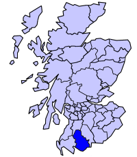
Stewartry is a committee area in Dumfries and Galloway, Scotland.

Tongland is a small village about 2 miles north of Kirkcudbright, in Dumfries and Galloway, Scotland. It lies on the west bank of the Dee near its confluence with the Tarff Water.
Dundrennan Range is a weapons testing range on the Solway Firth, near Kirkcudbright in Dumfries and Galloway, in south west Scotland. It is part of the Kirkcudbright Training Area, 4,700 acres (19 km2) of farming land acquired by the British Army in 1942 to train forces for the invasion of mainland Europe. The area includes a 15 x 19-mile (31 km) sea danger area. The range takes its name from the nearby village of Dundrennan.

MacLellan's Castle in the town of Kirkcudbright, in Galloway, Scotland, was built in the late 16th century. It stands in the centre of Kirkcudbright, on the south side of the River Dee which flows into the Solway Firth. The L-plan castle was the residence of the MacLellan family from whom it derived its name. The family sold the castle in 1752, and from 1782 to 1912 it was held by the Earls of Selkirk. Today, the site is curated by Historic Scotland.

Buittle is an ecclesiastical and civil parish in Dumfries and Galloway, southwest Scotland, in the traditional county of Kirkcudbrightshire. It lies to the west of the Urr Water, between Dalbeattie and Castle Douglas, and extends from Haugh of Urr in the north to Almorness Point on the Solway Firth in the south. The main settlement is the small village of Palnackie.
The Kirkcudbright Railway was a railway branch line linking Kirkcudbright to the Castle Douglas and Dumfries Railway at Castle Douglas. It opened in 1864, and closed in 1965.
Dundrennan is a village in the historical county of Kirkcudbrightshire in Dumfries and Galloway, Scotland, about five miles east of Kirkcudbright. Its population is around 230. It is most notable for the ruins of Dundrennan Abbey, a 12th-century Cistercian monastery. The weapons testing establishment Dundrennan Range is also nearby.

Saint Cuthbert Wanderers Football Club are a football club from the town of Kirkcudbright in the Dumfries and Galloway area of Scotland. They play in the South of Scotland Football League.

Kirkcowan is an area about 15 miles in length, and from nearly two to nearly seven miles in breadth, comprising 30,580 acres, of which 7000 are arable, 300 woodland and plantations, and the remainder meadow, pasture in Machars, in the historical county of Wigtownshire, in Dumfries and Galloway, Scotland, with the village of Kirkcowan, bounded on the east by the river Bladnoch, on the west by the river Tarff, and is 6 miles W. by S.W. from Newton Stewart.

The Tarf Water is a river in the former county of Wigtownshire in south-west Scotland. It rises on the Ayrshire border (55.0048°N 4.7815°W) and flows in a generally southeastward direction to meet the River Bladnoch near the village of Kirkcowan (54.9103°N 4.5792°W). It has no major tributaries but is fed by numerous burns which drain an area characterised by drumlins and much of which has been afforested.

The River Tarff is a river in Inverness-shire in the Scottish Highlands. It rises between the hills of Gairbeinn and Geal Charn and flows northwards then southwestwards and finally north-northwestwards into the Great Glen where it enters Loch Ness at Fort Augustus. The middle and lower reaches of the river are confined within the gorge of Glen Tarff. Its headwaters have been dammed to form the Glendoe Reservoir which forms the upper water storage basin for the Glendoe Hydro Scheme which began operation in 2009.

Bridge of Dee, Galloway is a settlement on the River Dee, Galloway. It lies on the A75 just west of Castle Douglas, and north-east of Kirkcudbright.
Kirkcudbright Castle, was a castle that was located on the banks of the River Dee, in Kirkcudbright, Scotland.

Broughton House is an 18th-century town house standing on the High Street of Kirkcudbright, south-west Scotland. It was the home of Scots impressionist artist E. A. Hornel between 1901 and his death in 1933. During this time Hornel remodelled the house and created the Japanese-influenced gardens. Since 1950 it has been in the care of the National Trust for Scotland, and is maintained as "a living museum of Hornel’s life and work". The house is a category A listed building, and the gardens are included on the Inventory of Gardens and Designed Landscapes in Scotland.
Mistaken Creek is a stream in Grayson County, in the U.S. state of Kentucky.

Kirkgunzeon is a village and civil parish in Dumfries and Galloway, south west Scotland. The village is 10.4 miles south west of Dumfries and 4.1 miles north east of Dalbeattie. The civil parish is in the former county of Kirkcudbrightshire, and is bounded by the parishes Lochrutton to the north, Urr to the west, Colvend and Southwick to the south and New Abbey to the east.
The Stunakill Bank is a shoal approximately .65 mi west of The Point of Ayre, Isle of Man.


