Related Research Articles
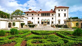
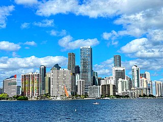
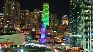
Miami, officially the City of Miami, is a coastal metropolis and the seat of Miami-Dade County in South Florida. With a population of 442,241 as of the 2020 census, it is the second-most populous city in the state of Florida after Jacksonville. It is the core of the much larger Miami metropolitan area, which, with a population of 6.14 million, is the third-largest metro in the Southeast and ninth-largest in the United States. The city has the third-largest skyline in the U.S. with over 300 high-rises, 58 of which exceed 491 ft (150 m).

Broward County is a county in the southeastern part of Florida, located in the Miami metropolitan area. It is Florida's second-most populous county after Miami-Dade County and the 17th-most populous in the United States, with 1,944,375 residents as of the 2020 census. Its county seat and largest city is Fort Lauderdale, which had a population of 182,760 as of 2020.

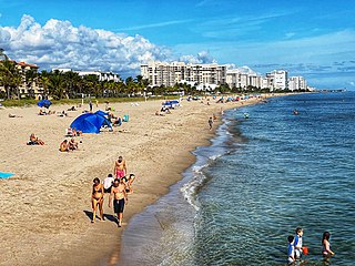
Fort Lauderdale is a coastal city located in the U.S. state of Florida, 30 miles (48 km) north of Miami along the Atlantic Ocean. It is the county seat of and largest city in Broward County with a population of 182,760 at the 2020 census, making it the tenth largest city in Florida. After Miami and Hialeah, Fort Lauderdale is the third largest principal city in the Miami metropolitan area, which had a population of 6,166,488 in 2019.
Lauderdale-by-the-Sea is a town in Broward County, Florida, United States, situated 33 miles north of Miami. The town is part of the South Florida metropolitan area. As of the 2020 census, the population was 6,198.

Plantation is a city in Broward County, Florida, United States. It is a part of the South Florida metropolitan area. The city's name comes from the previous part-owner of the land, the Everglades Plantation Company, and their unsuccessful attempts to establish a rice plantation in the area. As of the 2020 U.S. census, the population was 91,750.
Thousands of years before Europeans arrived, a large portion of south east Florida, including the area where Miami, Florida exists today, was inhabited by Tequestas. The Tequesta Native American tribe, at the time of first European contact, occupied an area along the southeastern Atlantic coast of Florida. They had infrequent contact with Europeans and had largely migrated by the middle of the 18th century. Miami is named after the Mayaimi, a Native American tribe that lived around Lake Okeechobee until the 17th or 18th century.
Brickell is a neighborhood in Miami, Florida located directly east of Interstate 95, south of the historic CBD, and north of Coconut Grove. Brickell is known as the financial district of Miami, as well as South Florida.
Downtown Miami is the urban city center of Miami, Florida. The city's greater downtown region consists of the Central Business District, Brickell, the Historic District, Government Center, the Arts & Entertainment District, and Park West. It is divided by the Miami River and is bordered by Midtown Miami's Edgewater and Wynwood sections to its north, Biscayne Bay to its east, the Health District and Overtown to its west, and Coconut Grove to its south.

Brickell City Centre is a large mixed-use complex consisting of two residential high-rise towers, two office buildings, a high-rise hotel, and an interconnected five-story shopping mall and lifestyle center covering 9 acres (36,000 m2) located in the Brickell district of Downtown Miami, Florida. Situated at the junction of Miami Avenue and Eighth Street, it spans up to five blocks to the west of Brickell Avenue and to the south of the Miami River. Contrary to the name, the development is not in the traditional downtown Miami city centre, but in the more recently redeveloped financial district of Brickell. The retail shopping and lifestyle center is operated by Simon Malls.
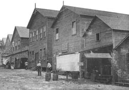
The history of Fort Lauderdale, Florida began more than 4,000 years ago with the arrival of the first aboriginal natives, and later with the Tequesta Indians, who inhabited the area for more than a thousand years. Though control of the area changed among Spain, England, the United States, and the Confederate States of America, it remained largely undeveloped until the 20th century. The first settlement in the area was the site of a massacre at the beginning of the Second Seminole War, an event which precipitated the abandonment of the settlement and set back development in the area by over 50 years. The first United States stockade named Fort Lauderdale was built in 1838, and subsequently was a site of fighting during the Second Seminole War. The fort was abandoned in 1842, after the end of the war, and the area remained virtually unpopulated until the 1890s.
Poinsettia Heights is a neighborhood in the northeast section of Fort Lauderdale, Florida, and its boundaries are west of Federal Highway, north of Sunrise Boulevard and adjacent to the neighborhoods of Lake Ridge and Middle River Terrace. The original development, called "North Ridge," was built by Gill Construction Company right after World War II in the 1940s and early 1950s.
The Seven Isles neighborhood comprises 315 households, with approximately 1,145 residents, and is situated north of Las Olas Boulevard. The Intracoastal Waterway borders the east and north boundaries, while the neighborhoods of Sunrise Key and Sunrise Intracoastal are to the north, the neighborhood of Central Beach is east of it, the neighborhoods of Idlewyld and Riviera Isles are to the south, Las Olas Isles is located southwest of it, and the neighborhood to the west of the Intracoastal Waterway is Nurmi Isles. There are nine streets within the Seven Isles: Aqua Vista Boulevard, Barcelona Drive, Castilla Isle, Del Mar Place, De Sota Drive, De Sota Terrace, Pelican Isle, Sea Island Drive and Seven Isles Drive.
Aladdin City is an unincorporated community in Miami-Dade County, Florida, United States. It is located about 20 miles (32 km) southwest of Miami within the unincorporated community of Redland. It is notable as the site of a planned community—similar to Opa-locka, Coral Gables, and Miami Springs, Florida—whose development was snuffed out by the abrupt end of the Florida land boom of the 1920s.

Buena Vista is a neighborhood in Miami, Florida, United States. It is located south of Little Haiti, north of the Miami Design District.
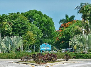
The Roads is a neighborhood of Miami in Miami-Dade County, Florida. It is a triangular area located south of SW 11th Street, between SW 12th Avenue and SW 15th Road, just west of Brickell.

The Greater Miami area, composed of the three counties of Miami-Dade, Broward, and Palm Beach, also known collectively as South Florida, is home to a wide variety of public and private transportation systems. These include heavy rail mass transit (Metrorail), commuter rail (Tri-Rail), automated guideway transit (Metromover), highways, two major airports and seaports, as well as three county-wide bus networks, which cover the entire urbanized area of South Florida. Census and ridership data show that Miami has the highest public transportation usage of any city in Florida, as about 17% of Miamians use public transportation on a regular basis, compared to about 4% of commuters in the South Florida metropolitan area. The majority of public transportation in Miami is operated by Miami-Dade Transit (MDT), which is currently the largest transit system in Florida and was the 14th largest transit system in the United States in 2011.

The Central Business District (CBD) of Miami is the historic central business district and city center of what has become Greater Downtown Miami in Miami, Florida. Over 92,000 people work in Miami's Central Business District.

Downtown Dadeland is an urban residential and retail development in Dadeland, Kendall, Florida, USA. Dadeland is an edge city in Kendall, which is part of unincorporated Miami-Dade County. Downtown Dadeland was completed in 2005, during a South Florida real estate boom. Notably, the 7.5-acre (3.0-hectare) development contains 15 acres of parking on two underground levels, unprecedented in South Florida, which averages under 10 feet (3.0 m) of elevation AMSL. Since then, some other projects have pursued more than one sub-grade level, including Brickell City Centre in the Brickell district of Downtown Miami. Underground development in the Miami area is complicated and expensive, due to the high water table. A project on Fort Lauderdale beach planned three levels of underground parking, but revised plans down to a single level mechanical parking garage. The mixed-use development is adjacent to Dadeland South station, the southern terminus of the Metrorail system, which saw significant ridership increases in the 21st century after many transit-oriented developments such as Dadeland were completed. Underground parking, including -1.5 and greater depths, began to become more common in the 2010s, pressured by building codes, aesthetics, and economics.
References
- ↑ "Neighborhood Associations" (PDF). City of Fort Lauderdale. Archived from the original (PDF) on February 16, 2008. Retrieved February 1, 2008.
- ↑ "The Council of Ft. Lauderdale Civic Associations, Inc.: Member Association Web Pages" (PDF). www.cflca.org. Retrieved February 1, 2008.