Related Research Articles
Esporte Clube Bahia, known familiarly as Bahia, is a Brazilian professional football club, based in Salvador, capital city of the Brazilian state of Bahia. They play in the Campeonato Baiano, Bahia's state league, and the Campeonato Brasileiro Série A, Brazil's first-tier league.

Bahia is one of the 26 states of Brazil, located in the Northeast Region of the country. It is the fourth-largest Brazilian state by population and the 5th-largest by area. Bahia's capital is the city of Salvador, on a spit of land separating the Bay of All Saints from the Atlantic. Once a monarchial stronghold dominated by agricultural, slaving, and ranching interests, Bahia is now a predominantly working-class industrial and agricultural state. The state is home to 7% of the Brazilian population and produces 4.2% of the country's GDP.

Sergipe, officially State of Sergipe, is a state of Brazil. Located in the Northeast Region along the Atlantic coast of the country, Sergipe is the smallest state in Brazil by geographical area at 21,910 square kilometres (8,460 sq mi), larger only than the Federal District. Sergipe borders Bahia to the south and west and Alagoas to the north. Aracaju is the capital and the largest city in the state; the state is divided into 75 municipalities. The state has 1.1% of the Brazilian population and produces only 0.6% of the Brazilian GDP.

Porto Seguro, is a city located in the far south of Bahia, Brazil. The city has an estimated population of 150,658 (2020), covers 2,287 square kilometres (883 sq mi), and has a population density of 52.7 residents per square kilometer. The area that includes Porto Seguro and neighbouring Santa Cruz Cabrália and Eunápolis holds a distinctive place in Brazilian history: in 1500 it was the first landing point of Portuguese navigators, principally Pedro Álvares Cabral. The crime rate is considered high, as is the case in the rest of Bahia.

The São Francisco River is a large river in Brazil. With a length of 2,914 kilometres (1,811 mi), it is the longest river that runs entirely in Brazilian territory, and the fourth longest in South America and overall in Brazil. It used to be known as the Opara by the indigenous people before colonisation, and is today also known as "Velho Chico".
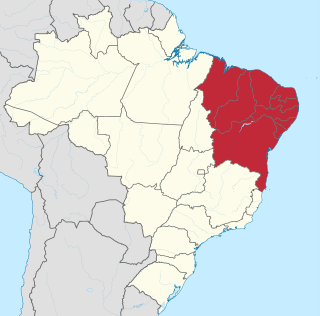
The Northeast Region of Brazil is one of the five official and political regions of the country according to the Brazilian Institute of Geography and Statistics. Of Brazil's twenty-six states, it comprises nine: Maranhão, Piauí, Ceará, Rio Grande do Norte, Paraíba, Pernambuco, Alagoas, Sergipe and Bahia, along with the Fernando de Noronha archipelago.

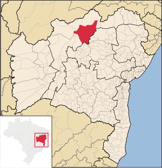
Juazeiro, formerly also known as Joazeiro, is a municipality in the state of Bahia, in the northeastern region of Brazil.

Ipiaú is a city in Bahia, Brazil. It is located at around 14°8′13″S39°44′2″W.
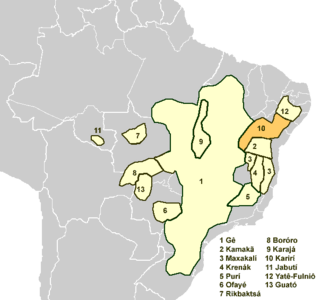
The Karirí languages, generally considered dialects of a single language, were a group of languages formerly spoken by the Kiriri people of Brazil. It was spoken until the middle of the 20th century; the 4,000 ethnic Kiriri are now monolingual Portuguese speakers, though a few know common phrases and names of medicinal plants.

São Francisco do Conde is a municipality in the state of Bahia in the North-East region of Brazil. São Francisco do Conde covers 262.856 km2 (101.489 sq mi), and has a population of 40,245 with a population density of 150 inhabitants per square kilometer. It is located 67 kilometres (42 mi) from the state capital of Salvador. According to the Brazilian Institute of Geography and Statistics São Francisco do Conde has the highest concentration of Brazilians of African descent (90%) in Bahia.

Jaguaripe is a municipality in the state of Bahia in the North-East region of Brazil. It covers 863.424 km2 (333.370 sq mi), and has a population of 18,981 with a population density of 18.32 inhabitants per square kilometer. Jaguaripe is located 130 km (81 mi) from the state capital of Bahia, Salvador. Jaguaripe shares a border with the municipalities of Aratuípe, Nazaré, Maragogipe, Laje, São Miguel das Matas, and Santo Antônio de Jesus. It was the first municipality created outside of Salvador, dating to 1693.

Nazaré, also known as Nazaré das Farinhas, is a municipality in the state of Bahia in the North-East region of Brazil. The municipality has a population of 28,594 with a population density of 107 inhabitants per square kilometer. It is located 110 km (68 mi) from the state capital of Bahia, Salvador. Nazaré is within the Bahian Recôncavo, an interior region of the state of Bahia. It borders the municipalities of Muniz Ferreira, Aratuípe, Jaguaripe, São Felipe, and Maragogipe. The Jaguaripe River crosses through the middle of the town. It is sits on the intersection of two Bahian state highways, BA-001 and BA-046.
São Félix, Bahia is a municipality in Bahia, Brazil. The municipality has a population of 14,762 with a population density of 142 inhabitants per square kilometer. It is located 110 km (68 mi) from the state capital of Bahia, Salvador.
Sento Sé is a municipality in the state of Bahia in the North-East region of Brazil. It covers 12,698.76 km2 (4,903.02 sq mi), and has a population of 40,989 with a population density of 1.28 inhabitants per square kilometer. Sento Sé is located 689 kilometres (428 mi) from the state capital of Salvador.

Glória is a municipality in the state of Bahia in the North-East region of Brazil. Glória covers 1,255.56 km2 (484.77 sq mi), and has a population of 15,234 with a population density of 13 inhabitants per square kilometer. It is located on the border of the states of Bahia, Pernambuco, and Alagoas on the banks of the Moxito River, now a lake as the result of the construction of Moxito Hydroelectric Power Plant.

Gongogi is a municipality in the state of Bahia in the North-East region of Brazil. It covers 195.39 km2 (75.44 sq mi), and has a population of 6,985 with a population density of 41 inhabitants per square kilometer. It was named after the Gongogi River which forms the southern border of the municipality.

Carinhanha is a municipality in the state of Bahia in the North-East region of Brazil. Carinhanha covers 2,529.45 km2 (976.63 sq mi), and has a population of 29,070 with a population density of 12 inhabitants per square kilometer. It is located on the banks of the Rio São Francisco and the Carinhanha River, which also forms the border of the state of Minas Gerais.

Feira da Mata is a municipality in the state of Bahia in the North-East region of Brazil. Feira da Mata covers 1,176.105 km2 (454.097 sq mi), and has a population of 5,661 with a population density of 5 inhabitants per square kilometer. It was originally part of Carinhanha, but became an independent municipality in 1989.

Cristóvão Jaques, also known as Cristóvão Valjaques, was a Portuguese noble of Aragonese descent.